Download GPX here and load in nakarte.me for an interactive map.

Introduction
My name is Laurent Berthod (Canada) and I have been watching a lot of your content recently, finding your will to explore solo very inspiring! I am a Quebecois hiker preparing a solo Himalayan traverse starting in Leh the 1st of October and ending at the border of Nepal, probably in Dharchula. I saw your blog post with Leon Perrin’s itinerary and was thinking of a similar route, but I am worried about the snowfall and the snowline, especially in the Himachal Pradesh region, as you said that options were quite limited in late October.
I am planning on linking waymarked trails in OSM and was wondering if I could get your opinion on a good route to avoid unnecessarily dangerous passes. I plan on going as light as possible, but am pondering bringing my small portable stove and pot since villages may be deserted in early November? As well, I am completely open to financially compensate route planning and communication with you during the trip if need be. I don’t have the biggest budget, but I completely understand that such extensive knowledge of the Himalayas is rare and very valuable.
Summary
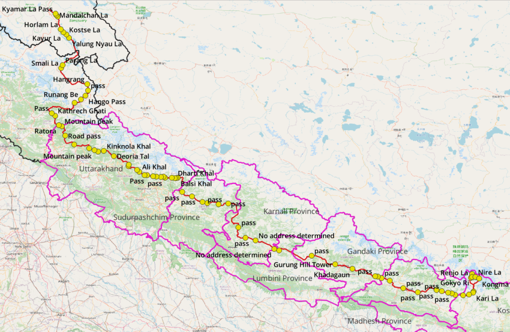
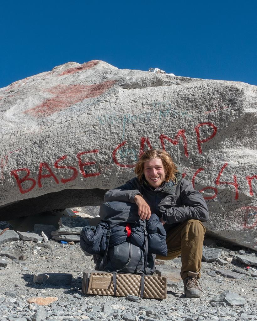
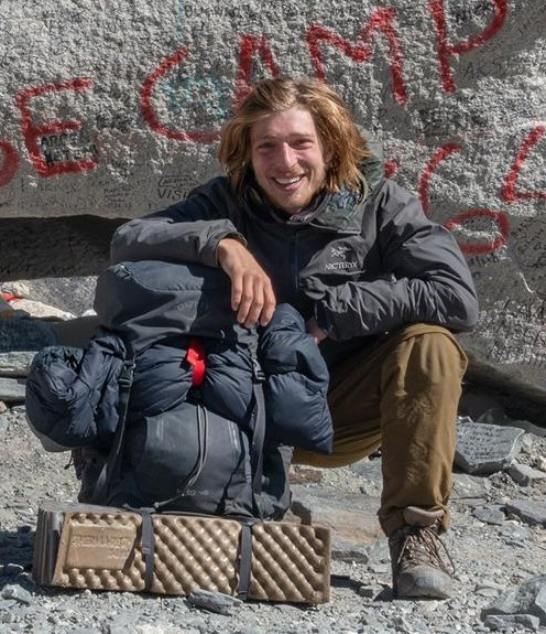
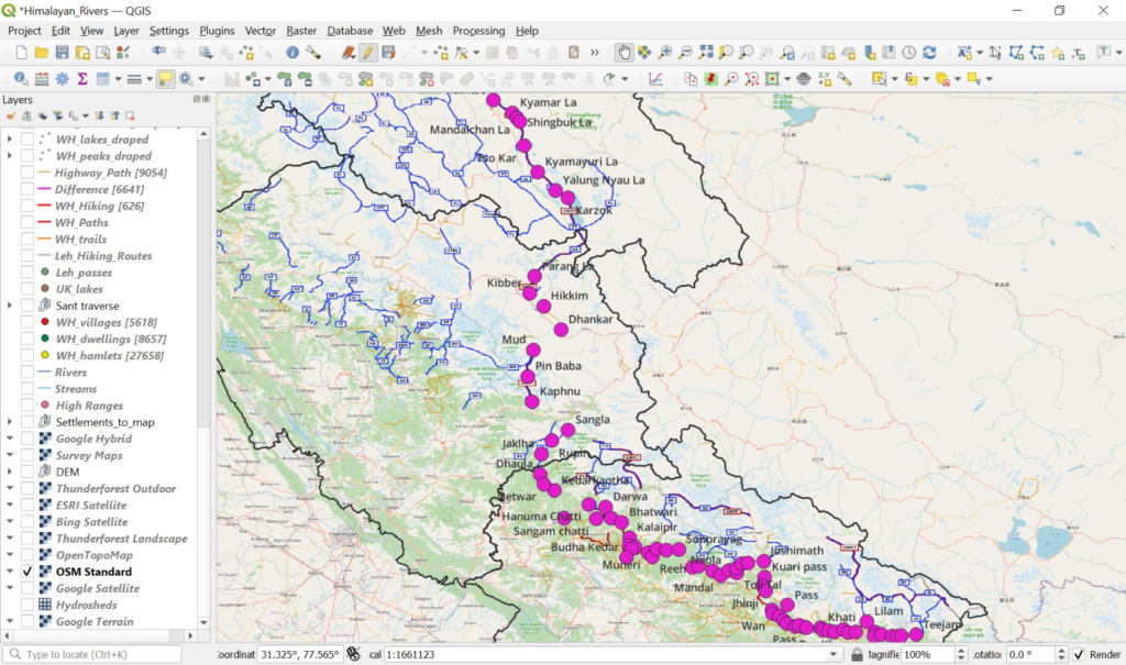
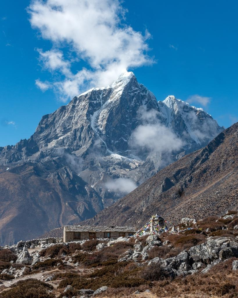
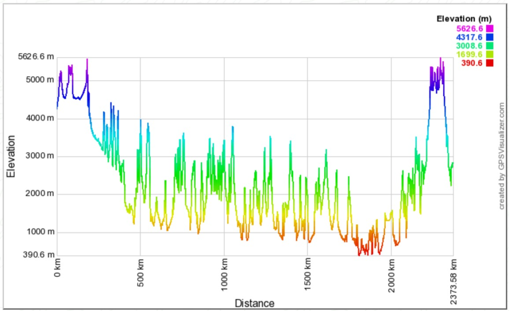
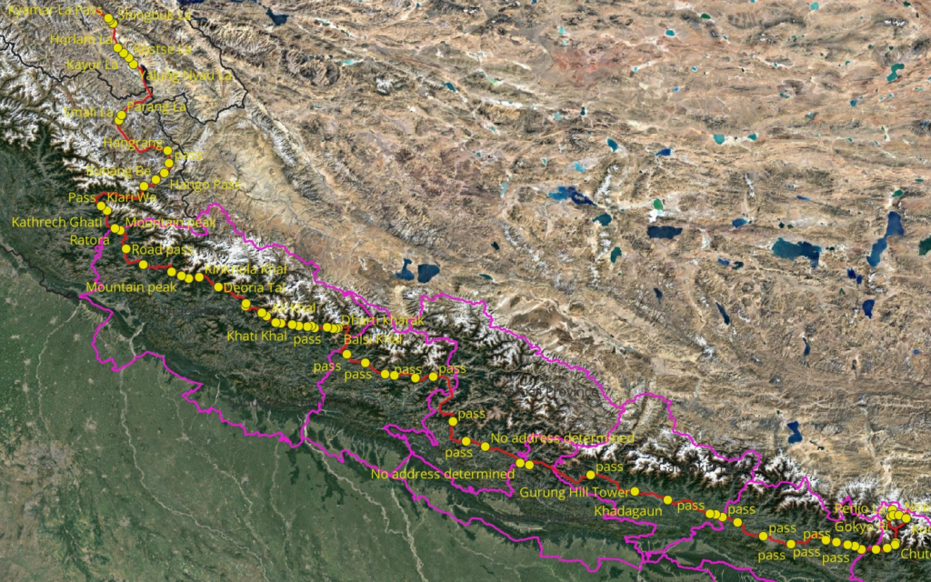
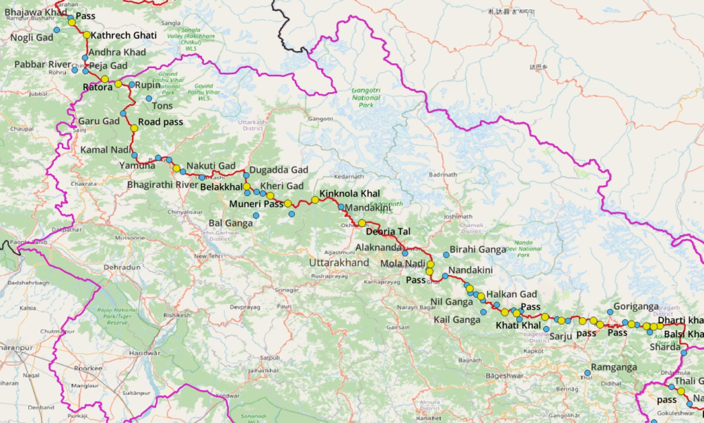
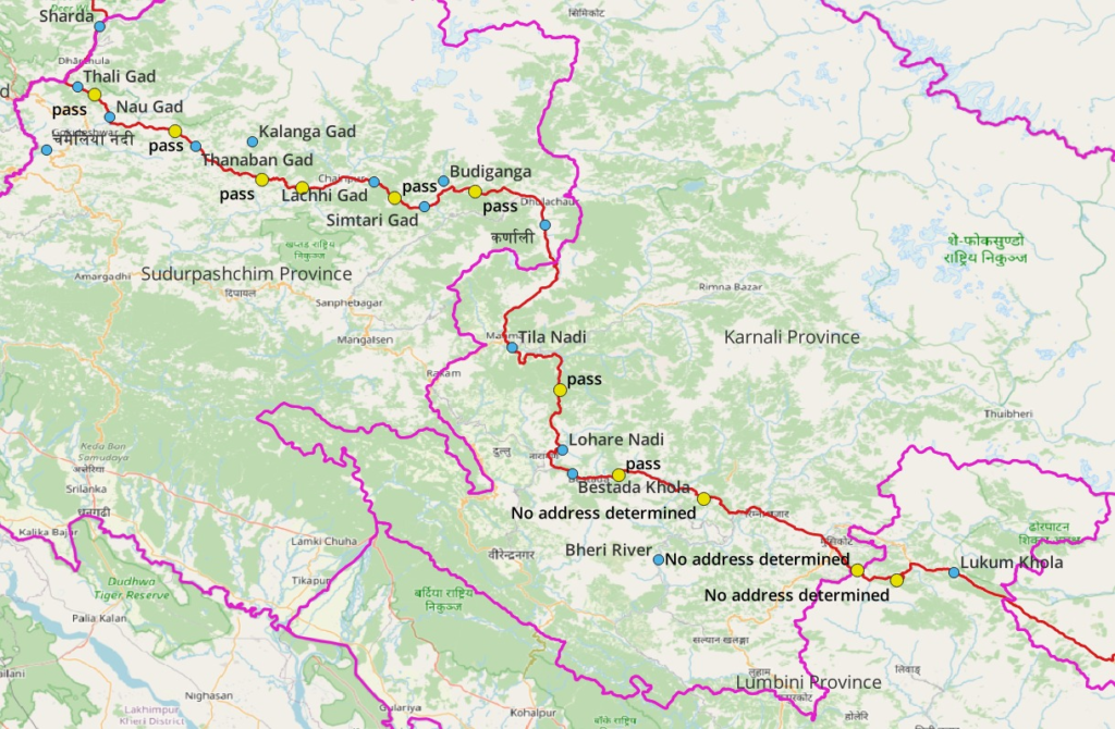
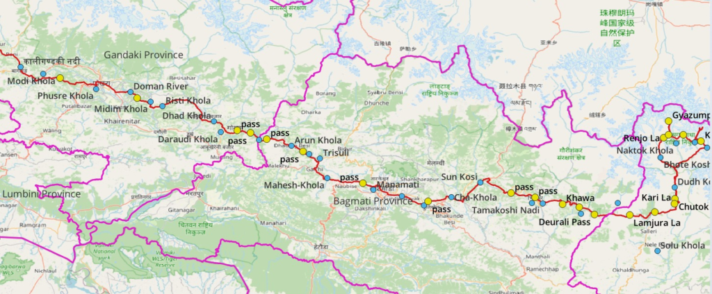
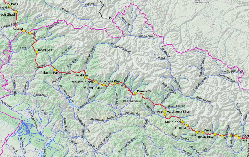
From October 2023 to January 2024 Laurent hiked 95 days covering 2600km across 75 mountain passes from Leh Ladakh to Everest base camp in Nepal. Starting from the alpine desert of Ladakh he crossed the states of Himachal, Uttarakhand (India) and Sudurpachchim, Karnali, Lumbini, Gandaki, Bagmati and Koshi provinces (Nepal) hopping 107 major river valleys. He climbed a total of 115 thousand meters of elevation gain (13 times height of Mt. Everest). He used both existing mapped Open Street Map hiking routes as well as explored new trails via the Survey Maps in India and following advice from locals in Nepal. He opened up a major new route from Spiti to Kinnaur along the Sutlej identifying undocumented trails via hires satellite maps. He went full alpine style, self-guided, minimalist gears, fast hiking (30km / day), food ration in villages in-between and minimal rest days.
Passes
| Pass | Lon | Lat | Ele |
| Kyamar La Pass | 77.895593 | 33.5310165 | 5099 |
| Mandalchan La | 77.9105866 | 33.504938 | 5208 |
| Shingbuk La | 77.943964 | 33.4718266 | 5279 |
| Horlam La | 78.0019641 | 33.2005237 | 4950 |
| Kayur La | 78.0625874 | 33.1365495 | 5410 |
| Kostse La | 78.1216657 | 33.0892944 | 5383 |
| Yalung Nyau La | 78.1789738 | 33.01681 | 5430 |
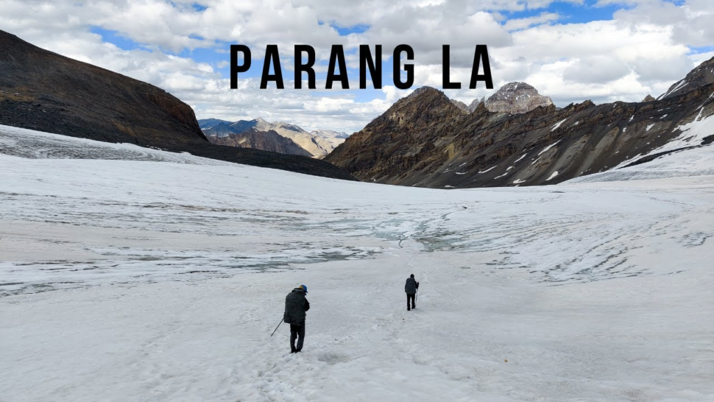
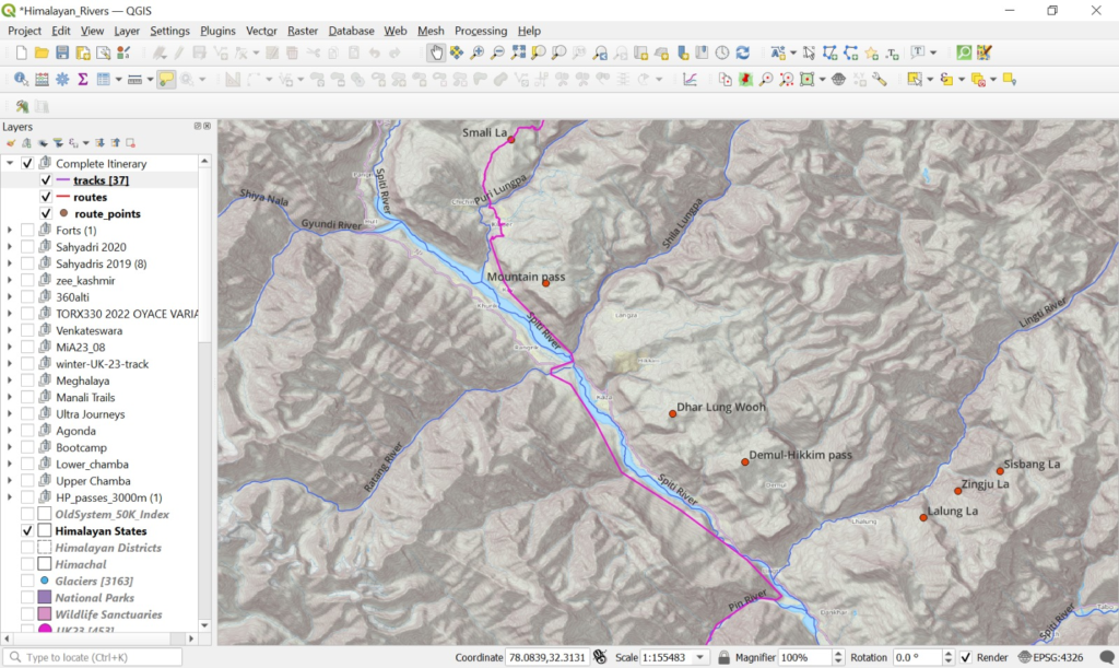
| Parang La | 78.042208 | 32.4469176 | 5568 |
| Smali La | 78.0141038 | 32.3849673 | 4708 |
| Hangrang | 78.5634416 | 32.0440233 | 4197 |
| Pass | 78.5781011 | 31.9093146 | 3801 |
| Hango Pass | 78.5254562 | 31.7946814 | 4413 |
| Runang Be | 78.4292132 | 31.7218795 | 4352 |
| Kiari We | 78.2967013 | 31.6514133 | 4233 |
| Pass | 77.8160602 | 31.4280497 | 3195 |
| Kathrech Ghati | 77.8832763 | 31.3717762 | 3934 |
| Ratora | 77.966981 | 31.1723553 | 3908 |
| Mountain peak | 78.0259269 | 31.150243 | 3661 |
| Road pass | 78.0979711 | 30.949968 | 1942 |
| Palachu Pass | 78.2899046 | 30.7675779 | 2360 |
| Belakkhal | 78.6064643 | 30.6874014 | 2932 |
| Mountain peak | 78.7133127 | 30.6451213 | 3257 |
| Muneri Pass | 78.7925774 | 30.6109764 | 3366 |
| Kinknola Khal | 78.9159805 | 30.6262432 | 3533 |
| Deoria Tal | 79.1271293 | 30.5219364 | 2360 |
| Agichaura Khal | 79.4373268 | 30.3352595 | 2815 |
| Pass | 79.4337004 | 30.3030112 | 2419 |
| Kukin Khal | 79.6148729 | 30.2271322 | 3107 |
| Ali Khal | 79.6646923 | 30.1904111 | 3451 |
| Pass | 79.7720236 | 30.1183663 | 3357 |
| Pass | 79.8266011 | 30.1155033 | 2776 |
| Khati Khal | 79.9536735 | 30.0971399 | 2917 |
| Mandhari Kharak | 80.027622 | 30.0824448 | 3037 |
| Sur Sungri Khal | 80.1233178 | 30.0789355 | 3158 |
| Rur Khan pass | 80.1723701 | 30.0825423 | 3448 |
| Pass | 80.2040103 | 30.0634462 | 3457 |
| Pass | 80.3449327 | 30.0647206 | 2806 |
| Dharti Khal | 80.4117036 | 30.0565306 | 3426 |
| Dharti kharak | 80.4458535 | 30.0544366 | 3800 |
| Balsi Khal | 80.4737163 | 30.0587871 | 3897 |
| Pass | 80.5677952 | 29.7622795 | 2232 |
| Pass | 80.7735748 | 29.6705595 | 2117 |
| Pass | 80.9943857 | 29.54735 | 2583 |
| 68DR008 | 81.0639809 | 29.5247474 | 1904 |
| Pass | 81.0982778 | 29.5265315 | 2101 |
| Pass | 81.3333865 | 29.4999279 | 3237 |
| Pass | 81.5372815 | 29.5164852 | 3523 |
| Pass | 81.7527241 | 29.0104535 | 3399 |
| Pass | 81.9023939 | 28.7949492 | 2536 |
| Pass | 82.119162 | 28.7347213 | 2475 |
| Pass | 82.5092601 | 28.5513547 | 2376 |
| Pass | 82.6099222 | 28.5266791 | 2652 |
| Pass | 83.2972229 | 28.4157077 | 2633 |
| Gurung Hill Tower | 83.7950903 | 28.2300375 | 2490 |
| Khadagaun | 84.1616464 | 28.1366134 | 1113 |
| Pass | 84.6367484 | 27.9819074 | 1064 |
| Pass | 84.699577 | 27.9692727 | 1016 |
| Pass | 84.7761631 | 27.9398795 | 1156 |
| Pass | 84.9468181 | 27.8815999 | 1333 |
| Pass | 85.2320887 | 27.7298959 | 1511 |
| Pass | 85.5416996 | 27.6435274 | 1572 |
| Pass | 85.9347527 | 27.6837076 | 2650 |
| Pass | 86.0482998 | 27.663195 | 1973 |
| Khawa | 86.1786691 | 27.6311211 | 2550 |
| Pass | 86.2598578 | 27.6161861 | 2399 |
| Deurali Pass | 86.3304055 | 27.5822467 | 2717 |
| Lamjura La | 86.4980382 | 27.5785142 | 3531 |
| Taksindu La | 86.6172677 | 27.5921837 | 3065 |
| Kari La | 86.7113167 | 27.6330726 | 2806 |
| Chutok La | 86.7129582 | 27.6561912 | 2784 |
| Kongma La Pass | 86.8364418 | 27.9301567 | 5512 |
| Renjo La | 86.6584933 | 27.9473742 | 5381 |
| Nire La | 86.7516357 | 27.9617271 | 5365 |
| Gyazumpa Tsho | 86.6826332 | 28.0252474 | 5152 |
| Gokyo Ri | 86.6831267 | 27.9615471 | 5341 |
Ladakh, Himachal
Uttarakhand
Sudurpaschchim, Karnali, Lumbini
Gandaki, Karnali
Valleys
| Valley | Lon | Lat |
| Mundar Tokpo | 77.7364147 | 33.6871211 |
| Kyammar Lungpa | 77.801528 | 33.5943171 |
| Tajurma Nala | 77.9038328 | 33.5177881 |
| Lungmarchan N | 78.0133098 | 33.3969851 |
| Spanglung | 78.0261201 | 33.1781939 |
| Gyamatsharma Nala | 78.0755639 | 33.109144 |
| Loma Nala | 78.120448 | 33.0778104 |
| Lam Lungpa | 78.1689101 | 33.0375169 |
| Karjok Phu | 78.2427514 | 32.9698551 |
| Gyama Nala | 78.277384 | 33.0620585 |
| Phirse Phu | 78.178373 | 32.8186572 |
| Pare Chhu | 78.326683 | 32.6432868 |
| Rug Lungpa | 78.0220914 | 32.4292788 |
| Puri Lungpa | 78.0283141 | 32.3634605 |
| Spiti River | 78.0571157 | 32.2339807 |
| Amdan Puh | 78.5431749 | 31.9305302 |
| Libak Dogpo | 78.5399348 | 31.8980453 |
| Kirasang | 78.5534531 | 31.8328725 |
| Ropa Gad | 78.4510034 | 31.7672751 |
| Kirang Khad | 78.4118271 | 31.6505822 |
| Kashang Khad | 78.2326233 | 31.662217 |
| Bhajawa Khad | 77.8099394 | 31.4478313 |
| Nogli Gad | 77.7485007 | 31.3939646 |
| Andhra Khad | 77.8773755 | 31.2674735 |
| Pabbar River | 77.8288811 | 31.2128565 |
| Peja Gad | 77.8788775 | 31.2067544 |
| Rupin | 78.0870599 | 31.1481265 |
| Tons | 78.1642485 | 31.0847673 |
| Garu Gad | 78.0476153 | 31.0167042 |
| Kamal Nadi | 78.0999988 | 30.8272416 |
| Yamuna | 78.2077539 | 30.8163926 |
| Pathar Gad | 78.2558137 | 30.8068233 |
| Nakuti Gad | 78.3197254 | 30.7538272 |
| Bhagirathi River | 78.4044725 | 30.7286761 |
| Dugadda Gad | 78.6038518 | 30.7366809 |
| Pangrana Gad | 78.6097473 | 30.65814 |
| Kheri Gad | 78.6517185 | 30.6628744 |
| Dharm Ganga | 78.6791033 | 30.6566154 |
| Bal Ganga | 78.6493689 | 30.5553088 |
| Bhillangana River | 78.8106501 | 30.5623857 |
| Mandakini | 79.0331876 | 30.5942019 |
| Alaknanda | 79.3221635 | 30.3866106 |
| Birahi Ganga | 79.50899 | 30.3777208 |
| Mola Nadi | 79.4281429 | 30.3143299 |
| Nandakini | 79.5028478 | 30.2831772 |
| Semkor Gadhera | 79.60033 | 30.2405498 |
| Bagri Gad | 79.618054 | 30.2054563 |
| Nil Ganga | 79.6428752 | 30.2003426 |
| Halkan Gad | 79.6732645 | 30.1742516 |
| Kail Ganga | 79.676671 | 30.1193779 |
| Kuman Gad | 79.7374338 | 30.1533516 |
| Baura Gad | 79.8136139 | 30.1277344 |
| Ghatiya Gad | 79.8450708 | 30.1246628 |
| Pindar River | 79.8392075 | 30.0866271 |
| Sarju | 79.960379 | 30.0442303 |
| Khalpata Gad | 80.0090021 | 30.0880381 |
| Lamtara Rauli | 80.0577325 | 30.0807227 |
| Ramganga | 80.1470929 | 29.8455994 |
| Goriganga | 80.2495104 | 30.1209601 |
| Madakani Nadi | 80.3157771 | 30.0740706 |
| Paina Gad | 80.3689438 | 30.0629332 |
| Kulka Gadhera | 80.4237138 | 30.0571133 |
| Jimba Gadhera | 80.4272175 | 30.0306049 |
| Sharda | 80.5811548 | 29.9361881 |
| Thali Gad | 80.5249625 | 29.782658 |
| Nau Gad | 80.6073278 | 29.7064731 |
| चमेलिया नदी | 80.4470712 | 29.6222004 |
| Thanaban Gad | 80.8251822 | 29.6311163 |
| Kalanga Gad | 80.970633 | 29.6438125 |
| Lachhi Gad | 81.2797201 | 29.5397801 |
| Simtari Gad | 81.4074522 | 29.476647 |
| Budiganga | 81.4574862 | 29.5420623 |
| कर्णाली | 81.7145866 | 29.4323561 |
| Tila Nadi | 81.6313952 | 29.1204162 |
| Lohare Nadi | 81.7604953 | 28.858323 |
| Bestada Khola | 81.7841083 | 28.7981704 |
| Bheri River | 82.0030582 | 28.5784873 |
| Lukum Khola | 82.7571774 | 28.5469389 |
| Myagdi Khola | 83.4817815 | 28.3797386 |
| कालीगण्डकी नदी | 83.6076468 | 28.2833657 |
| Modi Khola | 83.715359 | 28.2501131 |
| Phusre Khola | 83.9672559 | 28.1796427 |
| Doman River | 84.1292346 | 28.16495 |
| Midim Khola | 84.2246246 | 28.1170416 |
| Risti Khola | 84.2806292 | 28.0971634 |
| Dhad Khola | 84.5248336 | 28.0260951 |
| Daraudi Khola | 84.5575351 | 27.9740931 |
| Budhi Gandaki | 84.7391689 | 27.9367256 |
| Arun Khola | 84.8939592 | 27.9091489 |
| Ghatte Khola | 84.9765712 | 27.8692362 |
| Trisuli | 85.0287777 | 27.8483968 |
| Mahesh-Khola | 85.0626755 | 27.7541855 |
| Manamati | 85.281738 | 27.6986595 |
| Hanumante River | 85.417521 | 27.668782 |
| Punyamati River | 85.5220199 | 27.625435 |
| Cha-Khola | 85.6516832 | 27.6649622 |
| Sun Kosi | 85.7900637 | 27.7338985 |
| Chandrawati Khola | 86.0345525 | 27.6360191 |
| Tamakoshi Nadi | 86.0848224 | 27.6348405 |
| Khimti Khola | 86.2659895 | 27.5849046 |
| Likhu Khola | 86.4416152 | 27.635349 |
| Solu Khola | 86.6296327 | 27.4084998 |
| Dudh Koshi | 86.7106462 | 27.7117509 |
| Imja Khola | 86.8650502 | 27.8983875 |
| Lobuche | 86.8077636 | 27.9258626 |
| Naktok Khola | 86.7190415 | 27.9205445 |
| Bhote Koshi | 86.6451681 | 27.8518402 |
Planning
[29 Aug 2023 Peter]
Nice to connect with a solo lightweight hiker!
Leon is attending my Alpine Field Bootcamp in Manali on Sep 17-23 so he’ll just be 1 week ahead of you. Feel free to reach out to him in case you both are interested in teaming up.
Snowline
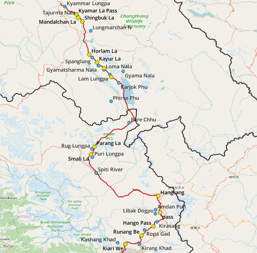
With respect to October / onset of winter – Ladakh & Spiti should be fine as they are behind the Great Himalayan Range, a 5-6000m wall which blocks most of the monsoon / snowfall. Beyond that we enter Kinnaur via Pin Baba (4850m) which gets directly hit by fresh winter snow – this might indeed be too optimistic to cross by the time you reach here in mid October. Next Rupin (4650m) to hop into Shimla could be another showstopper. Thanks for pointing out this error in the first draft plan.
Beyond that while traversing trans Uttarakhand I drop below 4000m which should probably be fine. Additionally I mapped lots of lower altitude passes in UK so here we can easily go higher / lower as per the actual snowline during winter 2023.
Spiti traverse
We have a few options to bypass Pin Bhaba / Rupin to get from Spiti to Kinnaur/Shimla:
1. We could follow the road – Kaza to Reckong Peo (East side of Spiti/Sutlej river) which of course beats the purpose of identifying a continuous hiking traverse
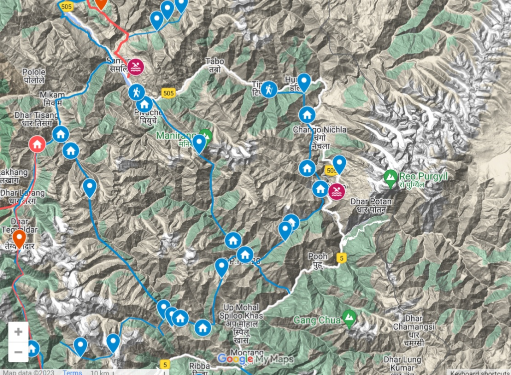
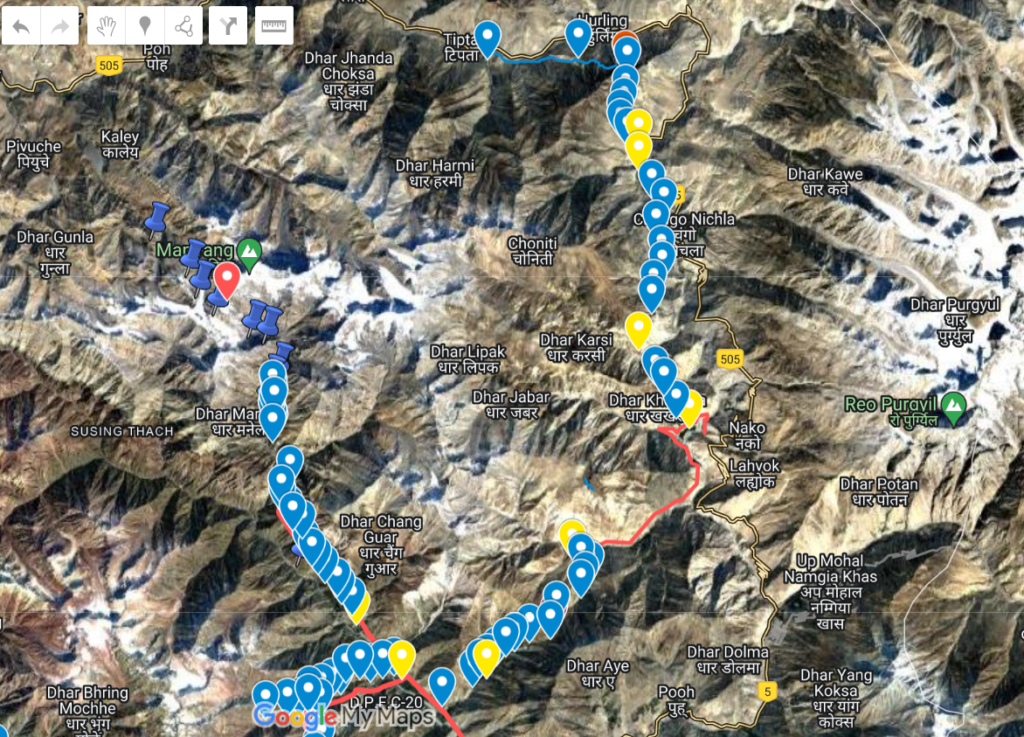
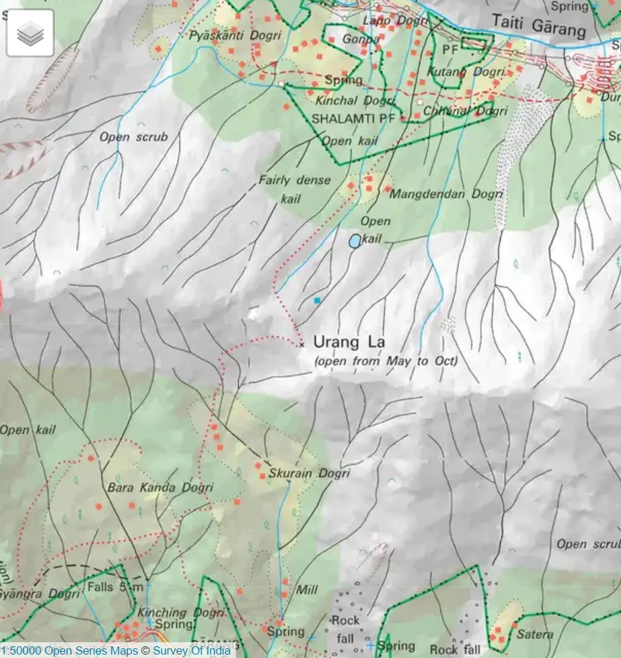
2. Alternatively there is a hiking path on the West side of Spiti/Sutlej river valley (not yet mapped in OSM) via Hangrang / Hango Pass / Rurang Be / Urang La to reach Reckong Peo. I have partly mapped this on via satellite maps and it’s also present on the Survey of India maps. Should be fairly easy to figure out as it connects various villages on the West bank.
3. Another option is to bypass Spiti altogether. Instead of Tso Moriri – Parang La – Kaza one could descend South towards Himachal via Sarchu (accessible through several routes) – Baralacha La – Chandra Tal – Attal tunnel and then follow a lower altitude traverse from Kullu valley towards Uttarakhand as per Sant’s Kullu_2_Nepal travers.
Avoiding dangerous passes – I have done some 350+ passes in the Himalayas so I can review any continuous traverse you connect and give you feedback on most passes.
Portable Stove
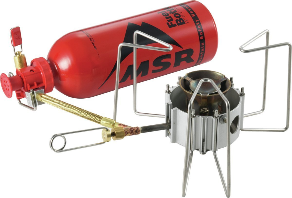
Portable stove – big NO – I ve traversed the India Himalayas in all seasons and especially in winter you are usually traversing lower altitude passes (sub 3-4000m) and therefore closer to the permanent villages (2-2500m) so resupply is easy. Most mid-altitude passes can be done in a single day so you hardly have to carry much food and most night stays are in the valleys / villages. A stove 400gr + fuel 600gr is too much of drag for a lightweight hiker.
Compensation
Compensation – no worries – always glad to share my experience in helping a fellow solo hiker. If you really want to appreciate my efforts then become a Patreon (advanced level) for a meagre monthly subscription. I’ll be most happy to guide you in planning a suitable traverse for the given season and dynamically adjust the route as per the actual weather conditions / snowline. I personally love those beautiful winter traverses and rerouting as per the dynamic snowline.
There are some 2000+ mountain passes, 13 thousand kms OSM routes and 63 thousand kms of Survey trails at our disposal so I always find a way!
[30 Aug 2023 Laurent]
Hi Peter!
First, thank you for responding this fast to my message! I subscribed to your Patreon and am looking forward to creating the best traverse possible! As you mentioned, those two passes (Pin Bhaba and Rupin) were my main concern. I estimated potentially crossing Pin Bhaba the 13th or 14th of October and the weather window may be closing by then, although I read somewhere it was potentially possible. In any case, I am considering roads only as a last resort, since as you said it defeats the purpose of a traverse.
Now, I am open to both options regarding a potential reroute if necessary, although I would prefer staying up north (through Reckong Peo), as I feel it would be a more direct route and the Rumtse – Karzok – Parang La – Kibber section sounds incredible! Also, there are many possibilities in Uttarakhand and I must say I am a bit overwhelmed by the amount of options. I examined Leon’s itinerary and it seemed to flow quite nicely, without many cuts where you have to walk on roads, but I would gladly have your opinion on the most aesthetic (flowy) and interesting route.
I also had a couple of questions regarding logistics :
– Do I need a special pair of sunglasses for the snowline (category 4 lens and side-eye protection for example)?
– I have a -2C sleeping bag, should I get a -12C like the one you used on your winter traverse?
– Is it worth it to bring some micro spikes for potentially technical glacier or moraine traverses considering my itinerary and the winter weather?
– I normally don’t use poles, in your experience, are they essential for the terrain I am going to be crossing, since streams are not going to be very large due to the winter conditions?
-How do you go about checking the weather without a cell signal, and how do you normally communicate with hikers when they don’t have reception? Is it worth trying to sneak in a satellite device?
I know it makes a lot of questions, so I really appreciate you taking the time to answer!
[30 Aug 2023 Peter]
Thanks for supporting me through Patreon. I quit my job in 2017 to pursue my passion of exploring and mapping the India Himalayas. I rented out my house, sold my car and am basically homeless now 😉 but happier than before!
If you prefer to stick to the Eastern Ladakh traverse till Kibber then we’ll find a way forward!
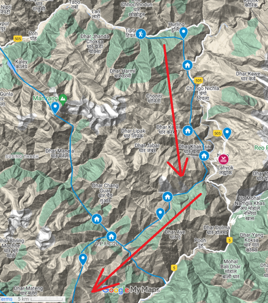
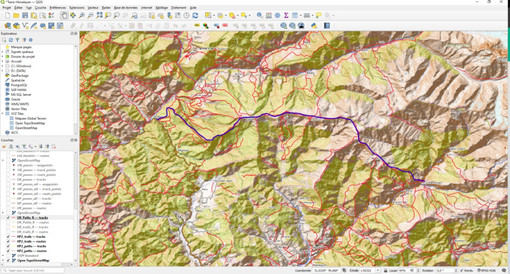
West Sutlej traverse
Sumra – Hangrang pass – Shialkhar – Yulang – Leo – Hango – Hango pass – Giabong – Temso lake – Lapo – Urang La – Pangi – Reckong Peo
Planning map
https://ultrajourneys.org/trans-himalaya-2020-passes/https://ultrajourneys.org/trans-himalaya-2020-passes/
Satellite Map
https://ultrajourneys.org/exploring-himalayas-using-hires-satellite-imagery/
Survey Map
https://storage.googleapis.com/soi_data/index.html
I suggest you review the hires satellite map above and refine it if you require more in between waypoints. Trails are generally quite easy to spot in the open / gradual alpine desert of Spiti
Shimla/Uttarakhand
I’ve explored some 3000km of routes in Uttarakhand – no worries about that side 😉 No matter how the snowline moves up or down we can easily get you through to Nepal. There’s so much mapped here that we can make a nice continuous traverse. One of my favorite places – raw and wild… and overwhelming hospitality as a solo hiker in these less touristic regions.
I suggest you take a look at Sant’s traverse (Kullu 2 Nepal) as a first start – he did this after my bootcamp in April when the snowline was around 3500m. (similar to October) You can join this traverse after Rampur. Sant was able to complete it 50% (he had to go back to work). Many of these passes are documented on my blog or Sant’s blog. Leon will follow more or less the same from Shimla/Uttarakhand.
Sunglasses
I never used sunglasses on my winter traverses but then again I recently noticed my lenses have some UV protection. Still…. Snow blindness is more likely in frozen morning snow with heavy sun reflection at higher altitude. Haven’t had any issues during my long winter traverses in the mid ranges. A normal sunglasses should do Laurent. We usually go through snow within a few hundreds of meters below the passes and then quickly descend into the forest below the snowline.
Sleeping bag
-2C should be fine. -12C is too bulky – it was only useful while camping on some exposed snow covered peaks just to capture the sunset/rise views. Usually we ll plan to camp in the valleys / villages at lower / warmer altitude. 50%+ of your night halts you’ll get hospitality in UK and you’ll sleep beneath cosy blankets in someone’s home.
Micro Spikes
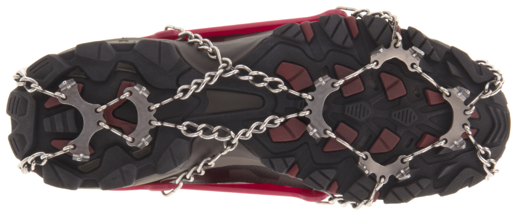
Don’t carry spikes please. We cannot justify carrying 350gr extra weight over such long traverses. We can easily avoid steep / hard snow / ice so you ll not require them especially in mid range during winter (mostly fresh snow / not hard during day at lower altitudes)
Hiking Poles
I also do not use poles to walk. I use them to 1. pitch up my ultra light tent or 2. some tricky stream crossings (not in winter obviously) or 3. cross steep landslide areas or 4. hike up steep / deep snow. My poles are carbon so just 250 grams. If you feel you don’t need them then drop them. As per my experience on long winter traverses they were useful though in case of (4).
Network Coverage
Mobile reception used to be a challenge in the Himalayas. Although in recent years it’s gotten much better now. Especially in Himachal/uttarakhand during winter at mid range altitude you might get a network 60% of the time which is frequent enough to get recent weather updates. Additionally, the weather is much more stable during winter compared to summer or monsoon. Get a JIO SIM which has wide coverage. You can try to sneak in a Garmin inReach – some are successful like Pete who just completed a long traverse through Ladakh/Zanskar – over here. Others say any they are stopped while entering and taken to the police station. So there’s risk.
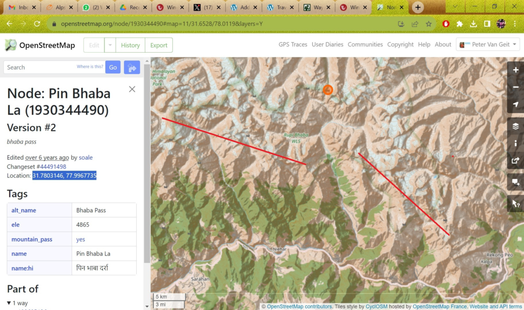
Pin Bhaba
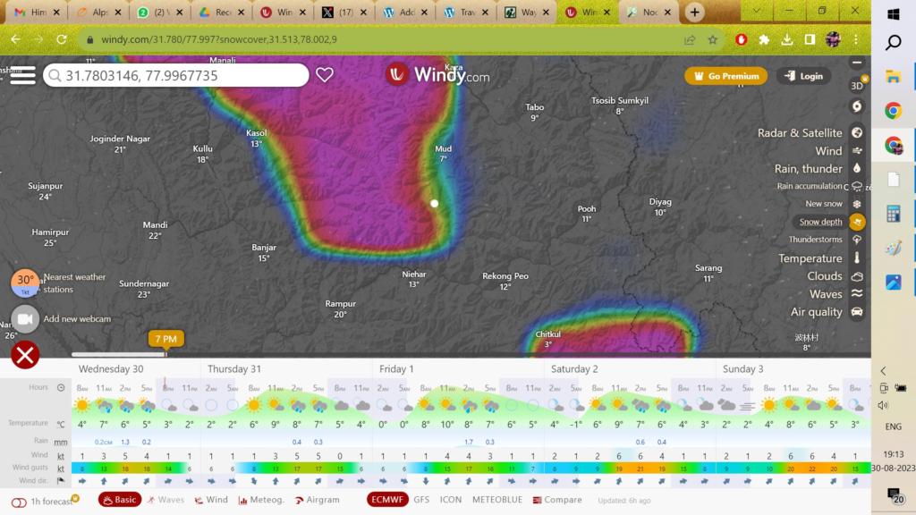
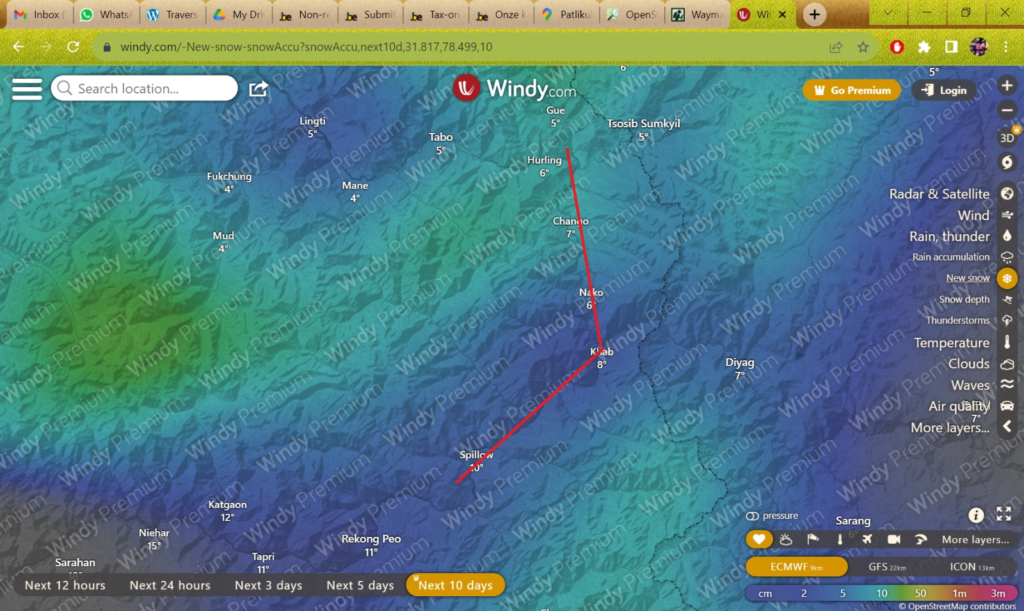
Digging a little deeper into crossing over from Spiti to Kinnaur via Pin Bhaba – refer attached.
Topography – PB seems shielded by a few high ranges (red lines, 5000m) from the South which could prevent it from getting more rain / snowfall early winter
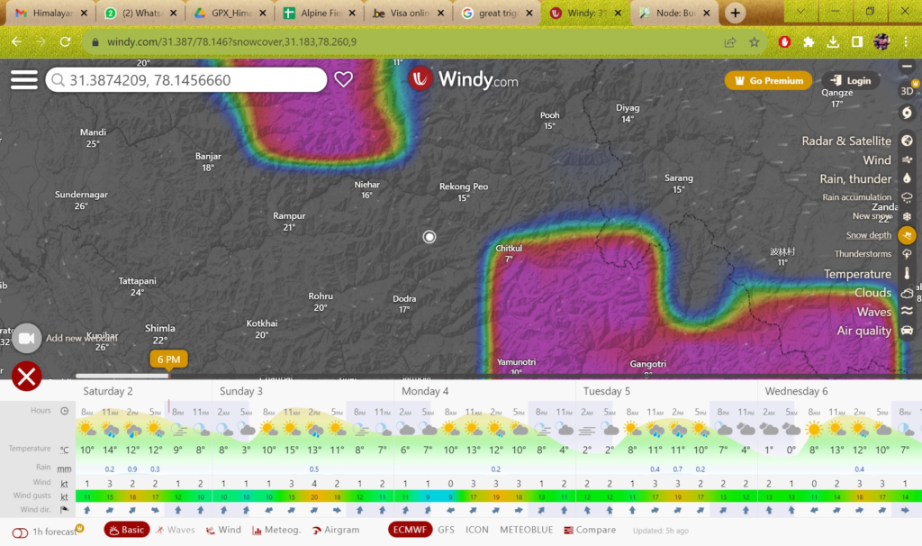
Precipitation (10 days from today, windy.com) – PB receives less rainfall (snow if sub-zero) compared to South/West so it appears to be shielded from current monsoon rains in foothills
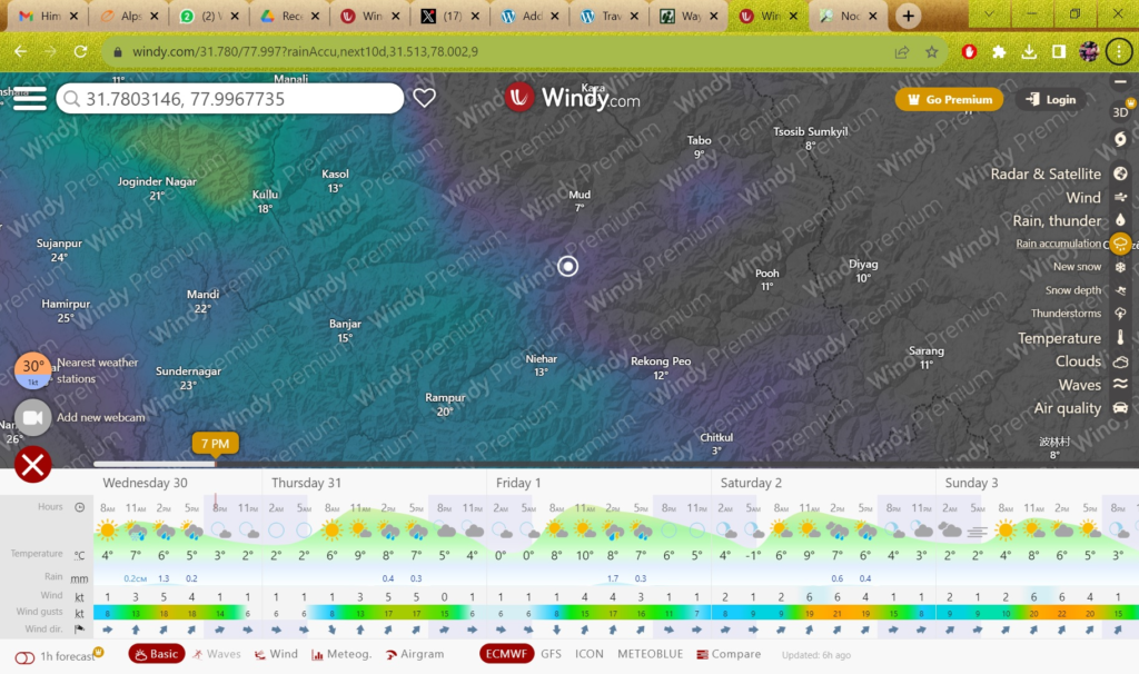
Snow depth – PB is on the edge here which is a positive sign.
We could take a call once you reach Kaza but my feeling says that you might still be able to cross it mid October. I’ve done PB and it’s a fairly straightforward approach (especially from Mud/Spiti). Bit steeper from Kinnaur. If the snow is too deep then simply take a bus from Mud back to Dhankar and follow the backup traverse on the West side of the Sutlej river to reach Reckong Peo.
[31 Aug 2023 Laurent]
Hi Peter!
Thank you for the extensive information about the West Sutlej Traverse as well as the weather info of PB pass. I agree that taking a call in mid October would be the best option, as I have heard that the PB pass is an incredible change of scenery and would love to traverse it if I can. Now, if I am able to take the PB pass, I imagine that the Rupin Pass would at this period be out of the question? In that case what would be the best alternative since I believe from that point on I think I absolutely have to head south to be comfortably below 4500m? I saw that the Buran Gatti named trail on OSM was a possible option to reach Chirgoan, but I probably have to look at the SOI maps since there are no OSM trails from that point.
As for the potential reroute through the West Sutlej Traverse, I am going to take some time to review the course and get back to you soon with probably a few questions!
Cheers!
[1 Sep 2023 Peter]
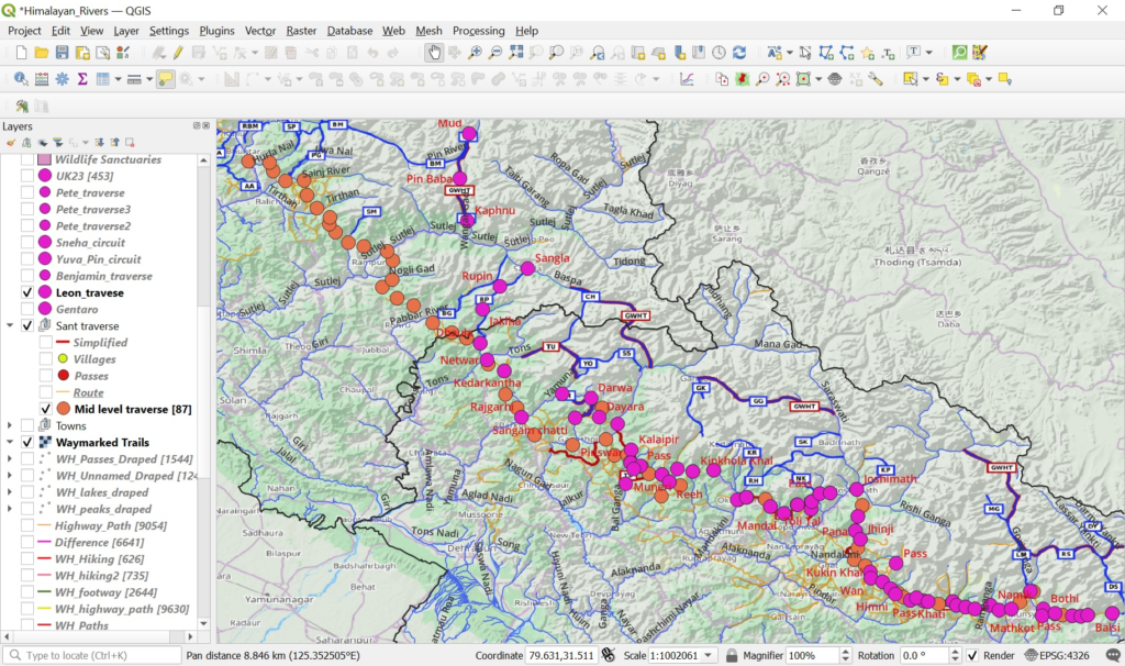
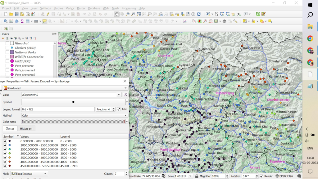
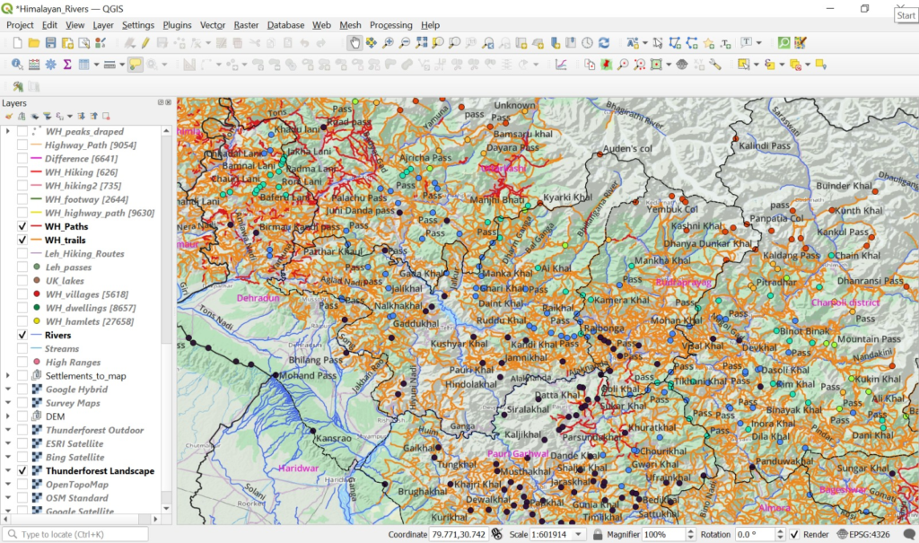
Which application are you using to plan your traverse? If nothing yet, I suggest you either use QGIS on laptop or OSMAnd on mobile. You can use any basecamp in these and overlay hiking routes to plan your continuous traverse. You can mark your passes, food stops and night halts.
Do you want to stay on pre-recorded (GPS) OpenStreetMap hiking routes or are you open to explore Survey of India map trails? If yes, you can download thousands kms of trails / paths from here.
Survey Map trails will give you a much more extensive trail network to choose from compared to OSM. Although legacy maps, these are usually 90% accurate. I have used them on various previous month long ultra journeys to explore, record and map 3000km+ new hiking routes in OSM.
Survey Maps are the most detailed available maps of the Indian HImalayas. They were created during the Great Trigonometrical Survey on India by the British in the 18th century and updated periodically after that. In OSM/QGIS you can overlay Survey Maps (bitmaps) using this overlay URL:
https://server.nikhilvj.co.in/soiredirect/{z}/{x}/{y}.webp
[1 Sep 2023 Peter]
In case you are interested to learn more on planning individual sections / pass crossings yourself:
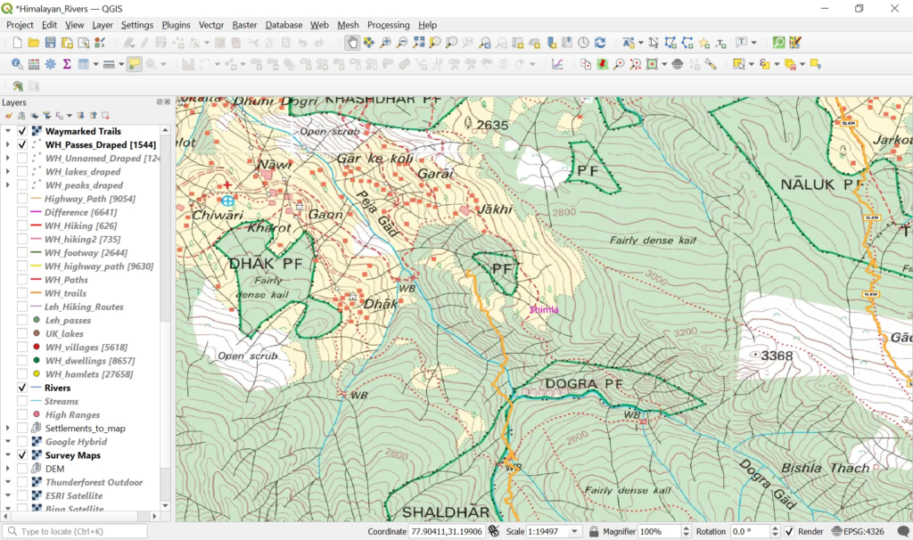
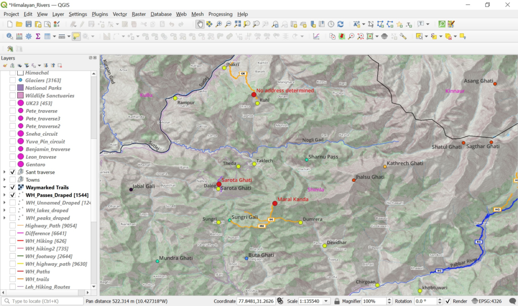
For example: say we wish to cross over from the Sutlej river valley (Rampur) to the Pabbar river valley (Chirgaon):
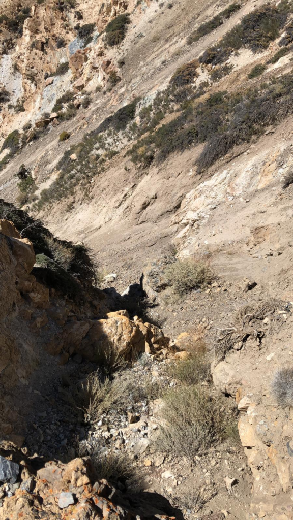
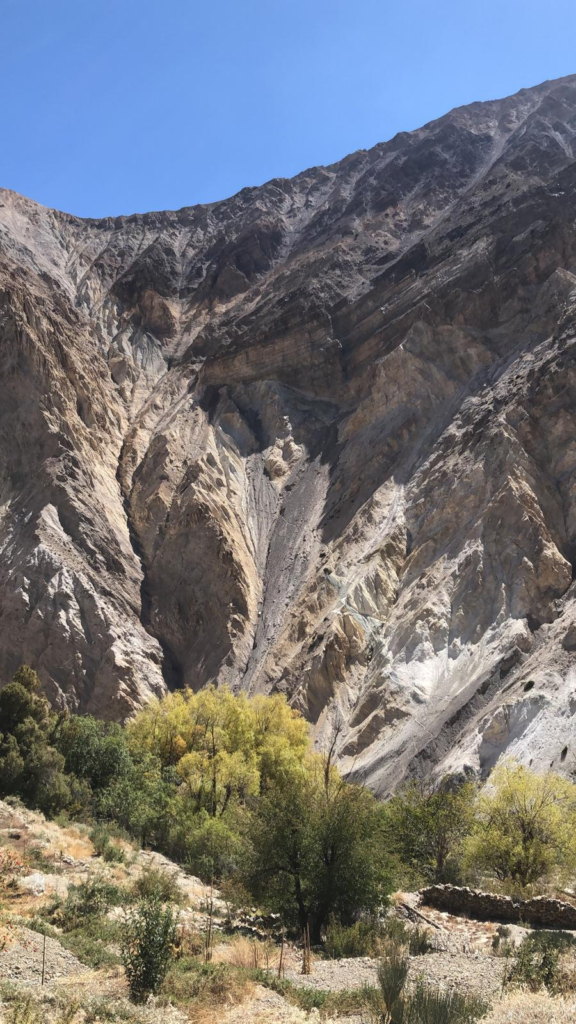
Option 1: In case you wanna give it a shot: Baspa valley – Barua – Buran Ghati (4560m) – Chirgaon. I did 4800m last year in the first week of Oct but each year the weather is different. Buran has direct exposure to new snowfall + steepness on the South side. Image below: current snow depth in Kinnaur – you can see that Buran is currently located in a snow – less corridor (which makes it more favorable). We can check snow depth mid Oct and make a call,
Option 2: Sant traverse, lower altitude, mapped in OSM: Jhakri – unnamed pass (2900m) – Kuhl – road section – Nogli Gad valley – Theda – Sarota Ghati (2700m) – Dalog – road section – Sungri – Maral Kanda (3720m) – Dumrera – road section – Chirgaon. These were Survey trails which Sant explored and mapped in OSM. He had to stay at a lower altitude last April as the snowline was around 3300m. These are smaller disconnected sections (road in between) as this lower altitude region is more inhabited. From Chirgaon onward it’s a more continuous traverse through green / forest regions.
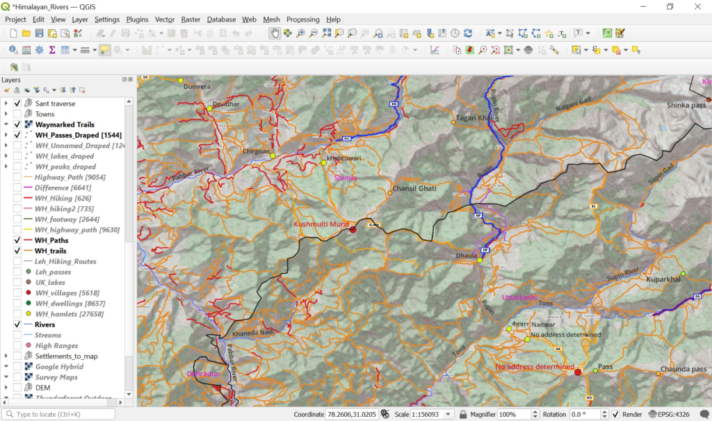
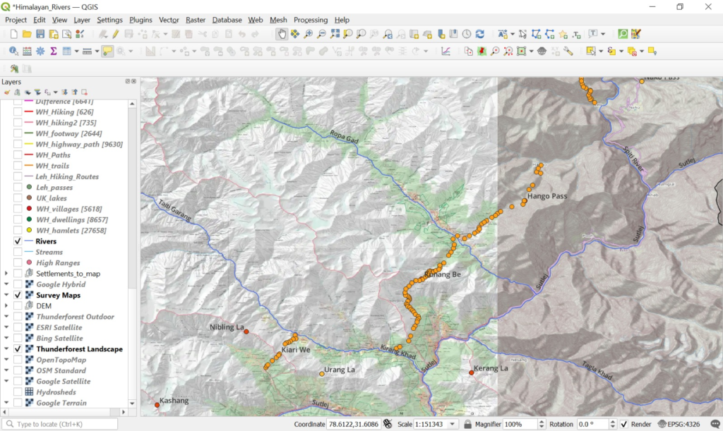
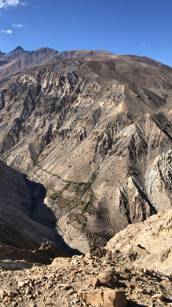
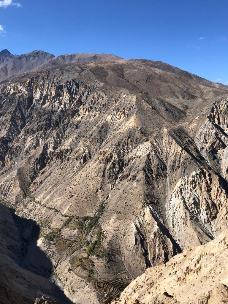
Option 3: If you wanna try something new you simply check the Survey maps – overlay the Survey GPXs (or map) I shared in the previous email and you’ll see multiple options to traverse from North to South. Additionally you can move between West (lower altitude, less snow) or East (higher altitude). Refer screenshot 3 attached:
- North
- Sutlej river valley
- Ridgeline 1 (purple) – three unnamed passes (blue circles): 2900, 3200, 3350m
- Nogli gad valley
- Ridgeline 2 (purple) – three passes: Maraln Kanda (3700m), Jhalsu Ghati (4150m), Kathrech Ghati (3900m)
- Pabbar river valley (Chirgaon)
- South
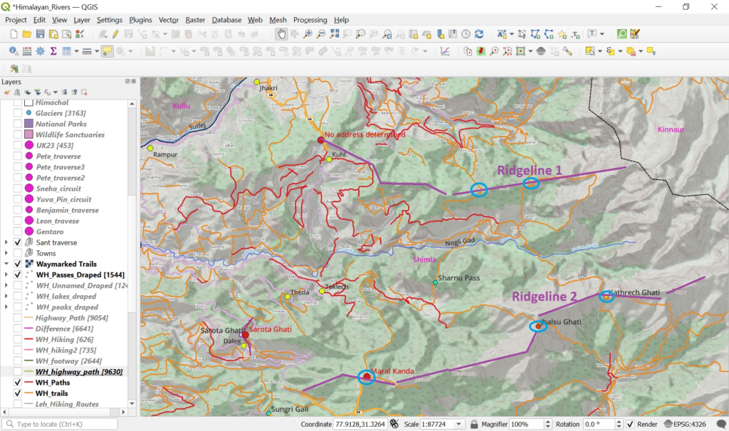
I usually keep my route dynamic based on the current weather / snow conditions and take the highest possible pass where the snow level is manageable (read: below knee level). As new snowfall occurs in between I simply move dynamically to lower altitude Survey trails.
[Laurent Sep 2nd]
Hi Peter!
I will definitely check all of those out and come up with a more detailed route which we can adjust afterwards. I will use OSMAnd on my phone and will also try QGIS on my computer. I am definitely open to exploring SOI trails during my traverse to make it more unique, so I will also try fusing the survey and OSM to find appealing routes!
[Peter Sep 3rd]
One thing I learned from my past winter journeys is to be flexible. You can have a fixed / planned route but based on actual weather / snow conditions always be ready to adjust the route to slightly higher / lower passes
With 2000+ mountain passes mapped across the Western Himalayas there’s is always the perfect crossing for any snowline 😉
And with 65 thousand Survey map trails you never run out of a backup routes
Leh to Kaza section you can consider fixed / straightforward as these are frequented by many hikers / accurately GPS recorded
We can just focus on studying / finetuning the Rampur 2 Nepal section. Once you enter Uttarakhand you ll have 3000km of OSM mapped routes also but it ll definitely be interesting to try to explore some Survey trails which have not been mapped yet. This will benefit the outdoor community
Traversing West to East you basically cross several ridgelines (passes) in between valleys (food, night stay). Each ridgeline has multiple passes to cross over – you just chose the highest one without pushing the snowline too much
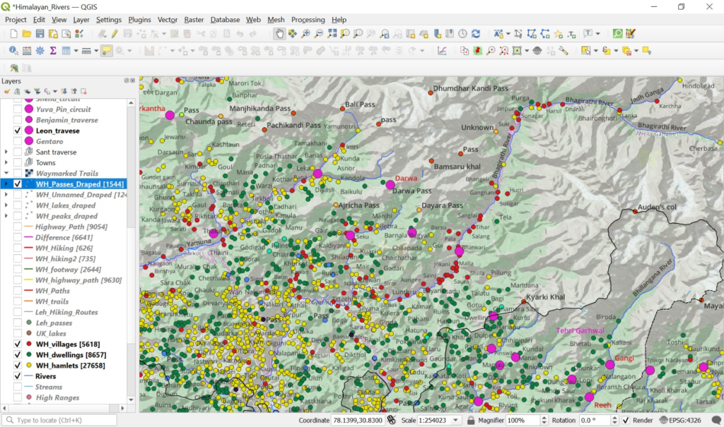
The beauty of the Indian Himalayas is that you ll find thousands of human settlements (villages/red, hamlets/yellow, dwellings/green) which are perfect spots for food supply and night halt. I usually connect the last inhabited settlements in each valley
[Laurent Sep 11th]
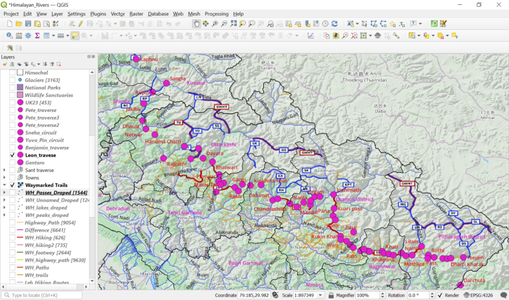
Hi Peter, after looking extensively at the potential options, I traced an 80% complete traverse using OSMand and QGis, I need to further mark the settlements and potential campsites, but it looks quite straightforward.
Kibber-To-Rampur and Chrigoan to Hanuman Chatti are the 2 sections where I am a bit less sure where to traverse. I checked the passes that you sent me but they seemed maybe a bit too high for the season? And the Survey Maps seemed to make big detours. I wonder if I should just follow the road south to connect to Human Chatti. Curious to see if you have any insights about this and if you have recommendations of things to add to my offline map as well!
I have identified 5 major road sections that I wondered if I could avoid :
- – Kafnu to Rampur
- – Rampur to (close to Dumrera)
- – Sonprayag to Okimath
- – Urgam to Joshimath (I saw there were SOI trails nearby, but they are incomplete and the elevation seems crazy)
- – Teejam to Dharchula
[Peter Sep 14th]
Kafnu to Rampur can be connected via Survey map trails along the North slope of the Sutlej river valley. It s not a straight line but it avoids the highway and goes through lower altitude trails connecting smaller hamlets
With respect to Rampur to Dumrera you could try below traverse instead:
- Start from Sarahan (instead of Rampur)
- Take bus to Mashhu
- 3200m pass
- Pat
- Sharnu pass 2900m
- Darkali
- Jhalsu Gati 4150m
- Ravasi
- Chirhaon
The Sonprayag to Okhimat section is indeed highway although mid way onwards you could follow some paths north of the Mandakini valley to reach Okhimat
Urgam to Joshimath – did you check out the trails on the west side of the Alaknanda?
Teejam to Darchula – the government has not released the border Survey maps so we have no further info on the region. Bus will be the only way forward here
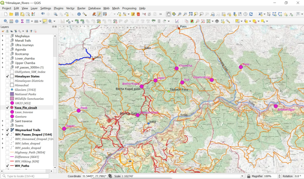
Instead of coming down to the road in Spiti valley you can do an upper traverse through Kibber – Tashigang – Langza – Hikkim – Demul – Dhankar
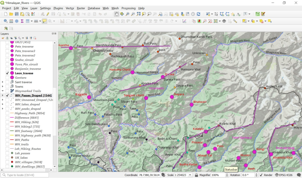
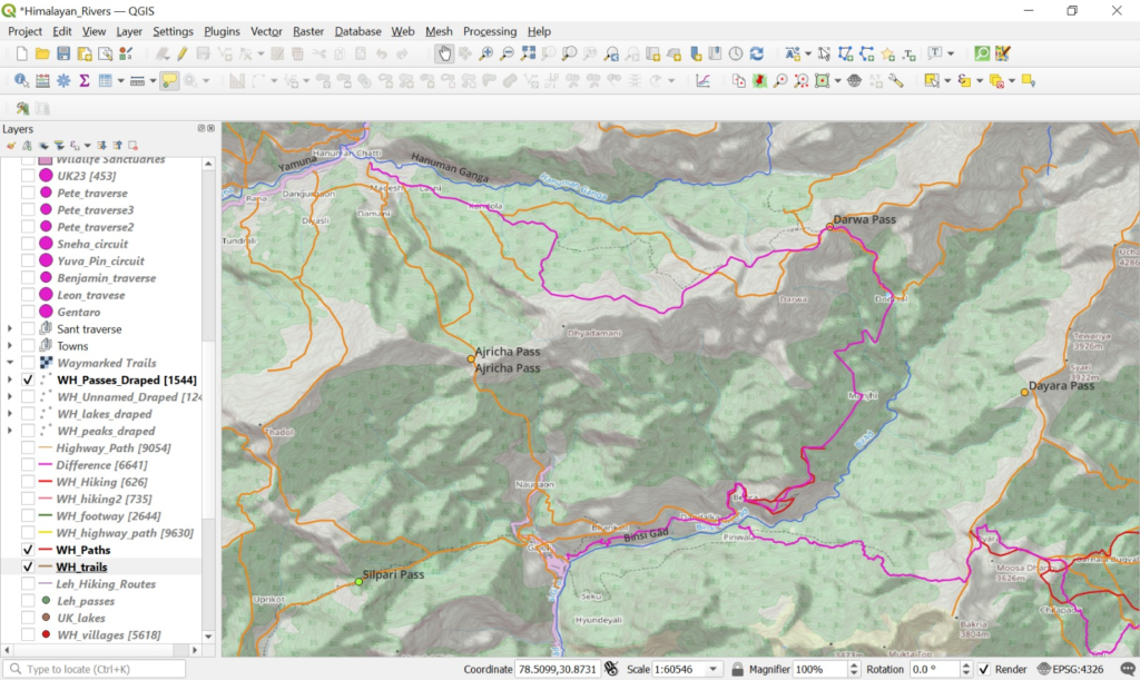
If possible try to explore / GPS record / map some survey routes instead of following already mapped OSM routes for some crossings: e.g. Ajricha pass instead of Darwa pass
The more Survey trails we explore and map into OSM the more extensive hiking network we create for the outdoor community
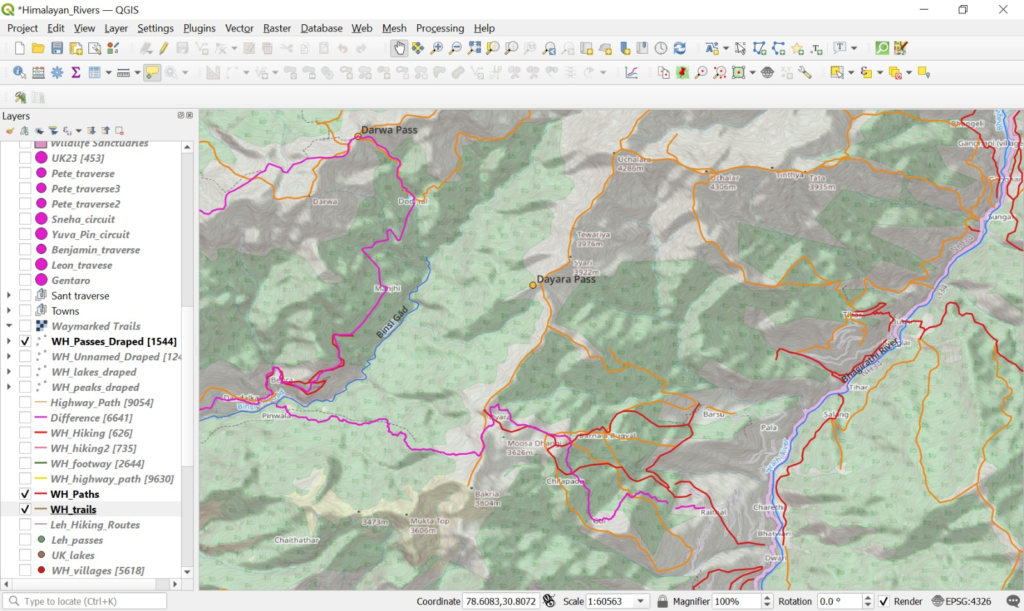
Depending on the snowline you can divert to higher altitude routes for some crossings: e.g. Pinwala – Dayara – Dayara pass – Uchalar – Sungar.
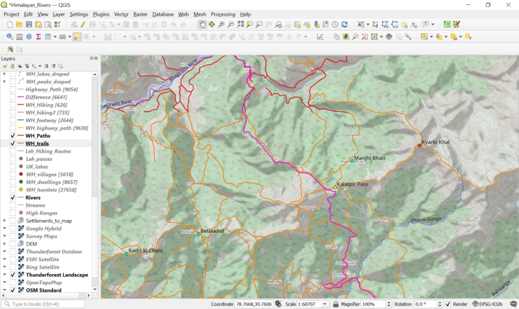
Based on my own experience during past Autumn/Winter traverses I usually keep my route dynamic as the snow line keeps changing – you usually have multiple options / passes to cross over: e.g. Kyarki Khal, Kalaipir, Belakhal, Badri ki Chani between Bhagirathi to Dharm Ganga valleys
[Peter Sep 16th]
Chirgoan to Hanuman Chatti: a few options below:
- Pabbar – Rupin valley:
Banwari – Tangan Khal 3600m – Dharagaon (Survey trail)
Chansal Ghati 3750m (road pass)
Jarkot – Ratora peak 3900m – Dhaula (OSM route)
Jakhi – ridge 3700m – Dhaula (OSM route incomplete)
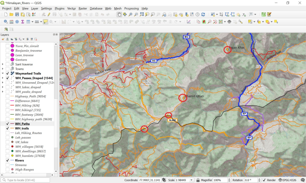
- Rupin – Yamuna valley:
Masri – ridge 3650m – Rekcha – Supin river – Kuparkhal 3500m – Tons river – Chaunda pass 3700m – Sar (Survey trail)
Tons river – Suchangaon – Kedarkantha 3800m – ridgeline South – Rajgarhi (OSM route, partly Survey trail)
Just load the Survey map trails to see various options between Chirgaon and Hanuman Chatti
I had a closer look at the Western slope of the Sutlej river valley and marked some trails on hires Google / Bing sat maps. This should be a good backup in case Pin Bhaba is closed by snow
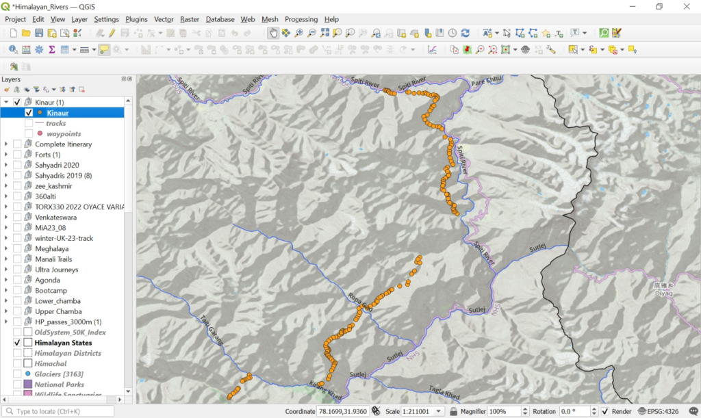
- Spiti river
- Sumra
- Hamrang 4200m
- Shalkar
- Spiti river
- Takal Tach 3850m
- Yulang Dogri
- Amdan Puh valley
- Pass 3800m
- Leo
- Spiti river
- Road section
- Hango
- Kirasang valley
- Hango pass 4400m
- Sunnam
- Ropa Gad valley
- Runang Be 4350m
- Kirang Khad valley
- Bhogtodogri
- Kiari We 4220m
- Kashang Khad valley
- Pangi
- Rampur
After the Hango Pass you have coverage by the Survey maps
You can clearly spot the trails on hires sat maps at 1:1000m scale
[Laurent 17th Sep]
Ok so I checked all of your propositions and ajusted my route accordingly. I have chosen to do the Spiti/Kinnaur western traverse instead of the PB pass, as I find it more interesting. My only concern was snow and the visibility of the trail, but if there is less snow in this area in late october then I think I will be fine. I downloaded the offline Survey map on my phone to make adjustements with the snowline if needed. I would need if possible the precise gpx file to get all the passes with their names attached, as the one I downloaded only shows the dots without the names on QGIS and the OSMand app on my phone.
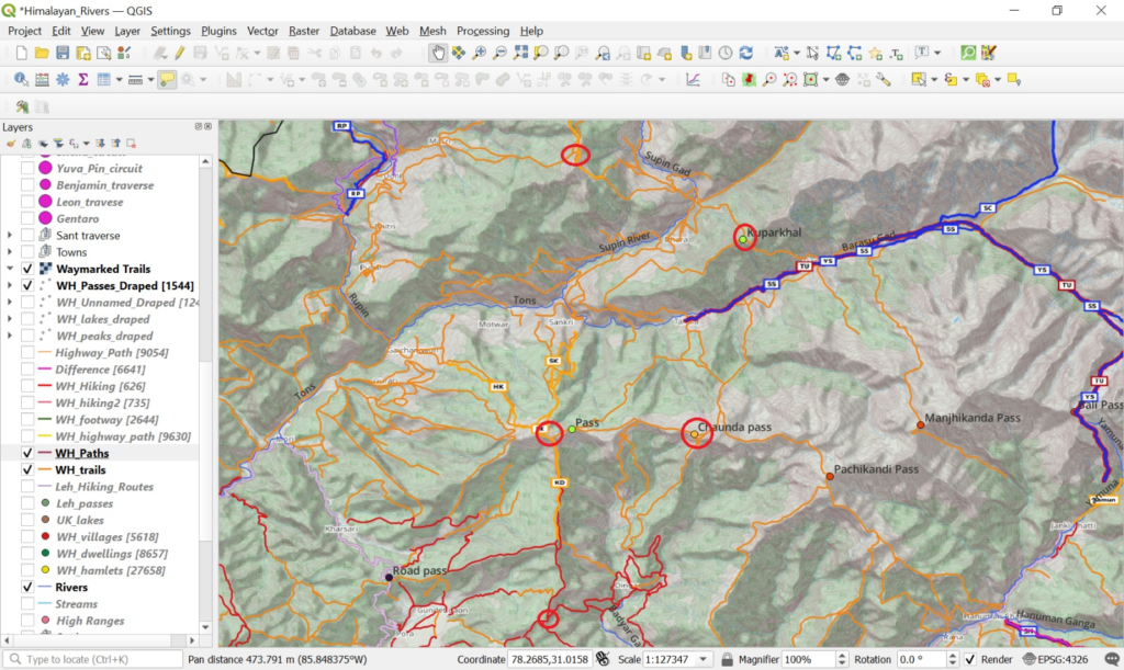
As for getting to Hanuman Chatti, I wondered if it was possible to follow the ridgeline the entire way to Kedar Khanta and then Chaunda and Mogarkanda as per highlighted in blue, as I find it is the simplest and purest way to get there?
Also do I need any permits along the way? I know I am crossing several national parks so I wondered if they had regulations about that? As well thank you for taking the time to analyse this extensively my traverse, it is a tremendous help!
[Peter 17th Sep]
The Spiti/Kinnaur Western Traverse will be an amazing addition to OSM. Please do GPS record this section. It ll open up a new connection between Spiti and Kinnaur !
I checked new snow for next 10 days along the Spiti / Sutlej valley and it looks minimal so I think you should be fine. We ll check again once you reach Kaza
Names of passes are on OSM and Survey maps. Some passes are unnamed. Let me know which ones are missing
The ridgeline from Kedarkanta to Hanuman Chatti would definitely be a beautiful option if the Survey trail is clear / still in use and not much above the snowline
Regarding permits – Yes PAP for foreigners and ILP for Indians. There were no check points entering Korzok (via Tso Kar). There is a police check point at the other end of the village but I think they’re more interested in tourists coming in by car.
I think technically you need 2 permits. The above mentioned PAP for the Ladakh side and another for the Spiti (HP) side. But info is rather lacking. I didn’t bother with the second permit. I did run into an army patrol (great guys!) when I reached the Pare Chu but they were only interested in my passport.
Langza to Dhankar is a nice high altitude traverse North of the Spiti valley instead of following the road from Kibber-Kaza-Dhankar in main valley. Find attached waypoints for the traverse Langzha to Demul and Demul to Dhankar
[Laurent 17th Sep]
I will be taking the northern route Langza-Dhankar! As for the PAP permits, I checked and all the tibetan settlements requiring a permit are not going to be on my itinerary, so I should be fine without them!
Also, after Dharchula, I am continuing my traverse to nepal where I plan to finish at Everest Base Camp. I know it is not related to the Indian Himalayas, but if you happen to know some good survey maps of Nepal (like the SOI for India) I would be grateful!
[Peter 18th Sep]
Good amount of snowfall at Pin Baba pass yesterday while Spiti / Sutlej valley backup route has much less
Topomaps for Nepal – https://nationalgeoportal.gov.np/topo/
OSM also appears to show lots of trails in Nepal although few are mapped as hiking routes in waymarked trails.
Not sure how accurate is windy but it shows snow depth as 35cm at Pin Bhaba. The Sutlej river valley seems like a “window of opportunity” as the snowline will descend in coming month
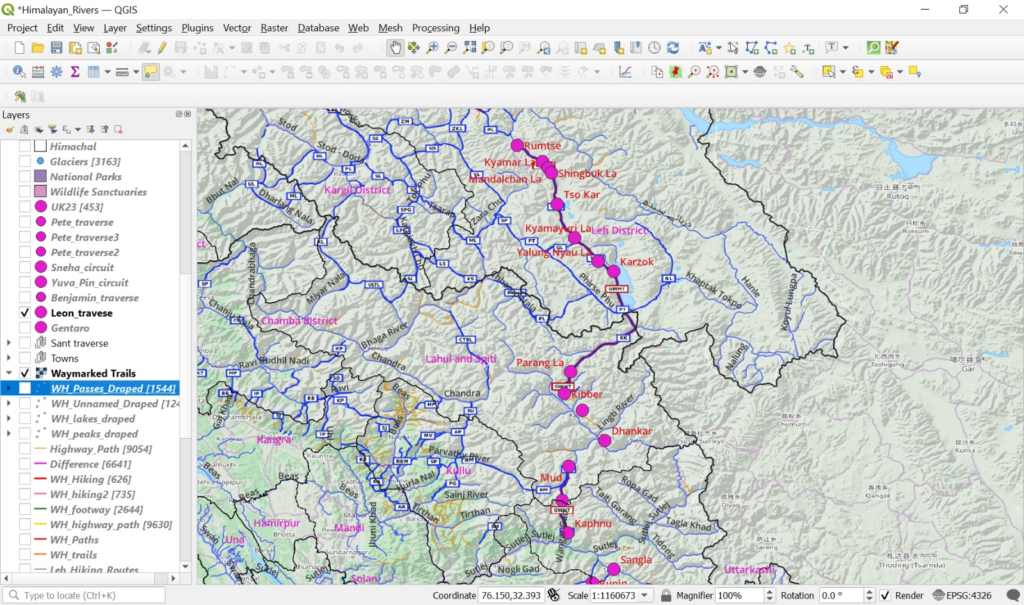
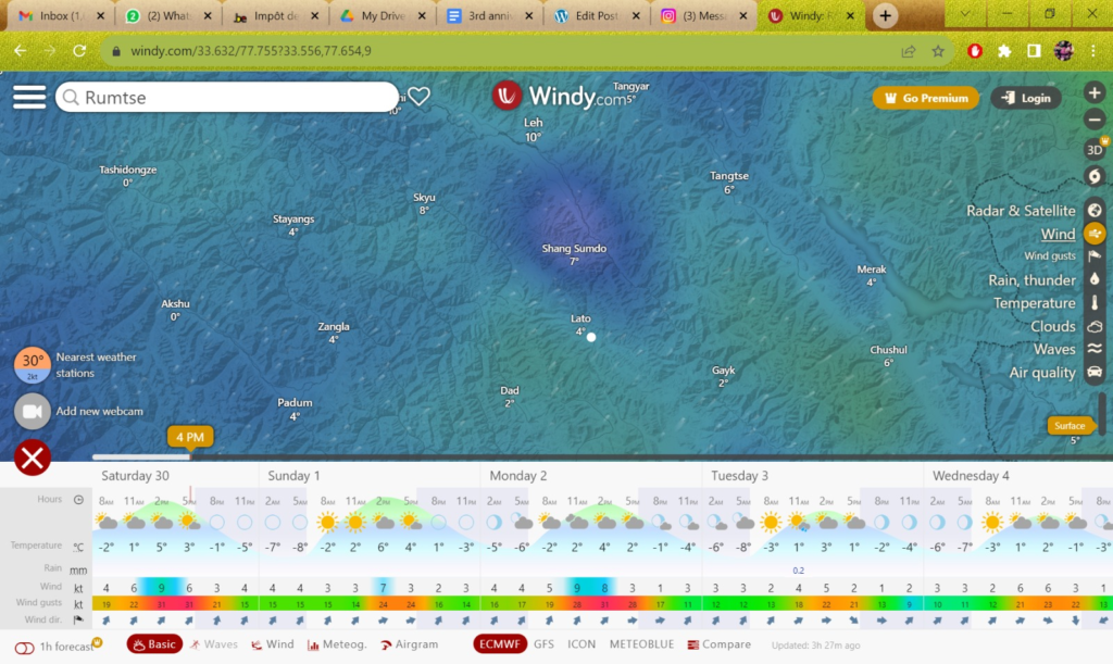
Find here the nine campsites for the initial high altitude section from Ladakah to Spiti via Rumtse to Tso Kar to Karzok to Kibber
[Laurent 21 Sep 2023]
For now, that is the full traverse, there are very tiny links that are not connected, but these are small road sections where I will try to find some SOI paths
Also, I wondered if you did your traverses with a GPS watch like a Garmin? And if so how you uploaded your route on it?
Are there identified caves or spots for camping on OSM? Since I have to be strategic with the altitude in the first days, I can’t climb straight up to 5500m and sleep and at 5000m coming from Leh (3500m)
As well, approximately how much money in cash will I need until Dharchula (+- 2 months)? How does it work when you ask for hospitality, do they expect money and if so how much?
[Peter 22 Sep 2023]
I used my Suuto watch to GPS record my traverses to save phone battery and as a backup to backtrack if phone fails. However for proper planning and navigation you really need a phone (screen size, memory, CPU) to view OSM / Survey maps
Get a Jio postpaid SIM in Leh which will allow you to stay connected during your traverse. This is the only SIM that will work in Ladakh
You ll have to properly acclimatize yes – Leh 3400m 1-2 days / Rumtse 4200m 1-2 days before you hit your first three passes at 5100-5200-5300m
Popular campsites are marked on OSM but you can chose any flat space along the way with close proximity to a running water stream
First possible campsite at 21 km / 4950m at the Tajurma Nala which is quite high. Ideally you should not camp at 500m increments above 3000m which means 3000-3500-4000-4500-5000m
Average expense for me is 200Rs per day or 6000Rs per month. Ladakh is commercial. Himachal / Uttarakhand you will experience non expecting hospitality – do not pay money to your host or he might get offended
Night temperatures are getting really cold in Ladakh at 4000m+
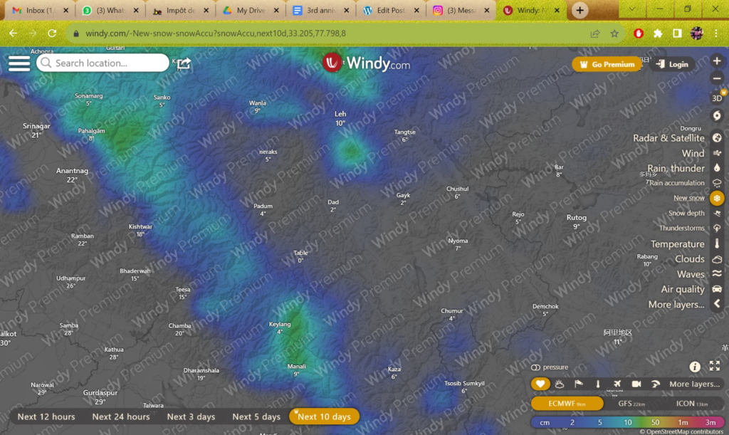
New snowfall in next 10 days – Rumtse-Karzok-Kaza traverse looks clear 👍🏻
Few cms of snow in the upper Spiti traverse but nothing heavy in next 10 days
[Laurent 1 Oct 2023]
I decided to carry a cooking stove because of my allergies to nuts/peanuts, I always want to have the option to cook if I am insure about a meal proposed to me. As such, my pack is a bit heavier, right now it is 10kgs, but I will try to remove some items along the way to get to 9kgs. Also carrying just a single bottle of water and minimal food won’t bring the weight up too much.
And just as a point of reference, how much distance do you usually cover in a day? Depending on elevation of course.
What sort of water treatment do you use? I have a small and light manual pump with chlorine tabs, but I am curious if I even need to treat water on streams above 4000m? And one water bottle is enough?
I have just heard from a guy that went many times in spiti that you need an inner line permit obtainable in Kaza to do the spiti kinnaur traverse. Apparently, on the main road to Tabo and Sumra, they check quite thoroughly. This would mean I would need to descend from Hikkim to Kaza and then go back up? In any case I will inquire if I can get the inner line permit in Kiber!
[Peter Oct 1 2023]
Once you reach the foothills in Kinnaur you can possible reduce your weight / baggage a lot as the temperatures will be much warmer and you ll reach a settlement each night
When properly acclimatized with going lightweight (5kg) I usually cover around 20-30km / 1000-2000m+ per day. Ladakh is usually gradual terrain with good trails so you could even push it to 40km if you make use of the entire day
In the foothills of the Himalayas I usually target 1 pass (3-4000m altitude) per day and night halt in the valleys / hamlets (2000m). This is usually around 15-20km / 1000m+ per day
I drink directly from streams. Running water from upper streams is clear. I carry an empty 500ml bottle. You ll find water everywhere except close to the passes
[Laurent 10 Oct 2023]
Hi! In Kibber right now, I think I will go straight to Kaza on foot get the permit and sleep there, I don’t want to lose a day since I have 4 months to get to Everest Base Camp. So far it’s been great! Good weather and Parang La was a bit of a challenge, but the scenery is incredible!
Main dhallenges? I would say the cold immediately after sundown, I was lucky and found either shelters or had very little wind when camping out completely exposed in the valley at 5200m, but it was still a bit hard to get good sleep. The altitude in itself was ok, no AMS at all, just tough at 5200m the first day. The other thing I underestimated was the amount of long sections on loose rocks, steep descents on screes, making it very unstable and tiring so
[Peter Oct 10 2023]
Light snow in upper spiti valley in next 5 days. Try to make it to Leo village (opposite Nako) soon where there s less snowfall
Lower spiti valley is also much warmer
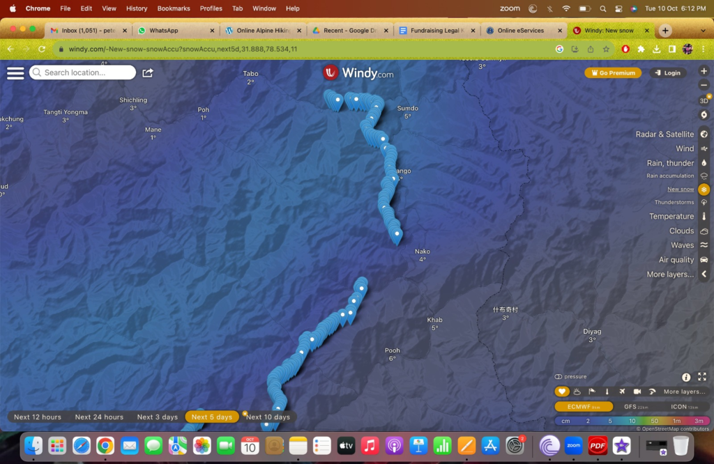
Overlaying your route on the new snow map (next 5 days) – light snow in Norther section, all clear in South section
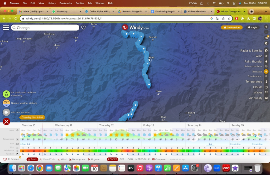
Good weather forecast next 3 days, light rain / snow on Sunday
Maybe check with locals in Leo whether there is any shortcut pass between Leo and Hango to avoid the road section. This section is not covered by the Survey maps
Above Pangi, Kalpa, Reckong Peo I see a lot of meadows and distributed homes on the map. You might find a trail here above the upper road
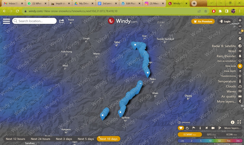
South of Reckong Peo I could trace a nice Survey route towards Saraha – download here. It proceeds on the South slopes of the Sutlej river valley passing through many small settlements and nice forest sections
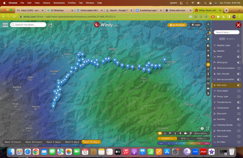
This route goes around the Baspa high ranges separating Kinnaur and Shimla which will receive more snowfall in the coming weeks. Once you circumvent this last high altitude range then you are a free man in the lower slopes of Shimla, Uttarakhand and no winter snow can stop you anymore
I just checked the Rupin pass – shortcut from Sangla into Shimla but I think you ll hit too much of snow in next 10 days and it’s a really steep descend South of the pass. Better to go around as per the “Reckong Peo South” traverse I feel
[Laurent 11 Oct]
In Tabo right now, starting the traverse tomorrow, do you know if there are any national post office along my traverse to ship my stove and pot to lighten my weight? I would ship them to Kathmandu, so not that far. Maybe in Reckong Peo?
[Laurent 13 Oct]
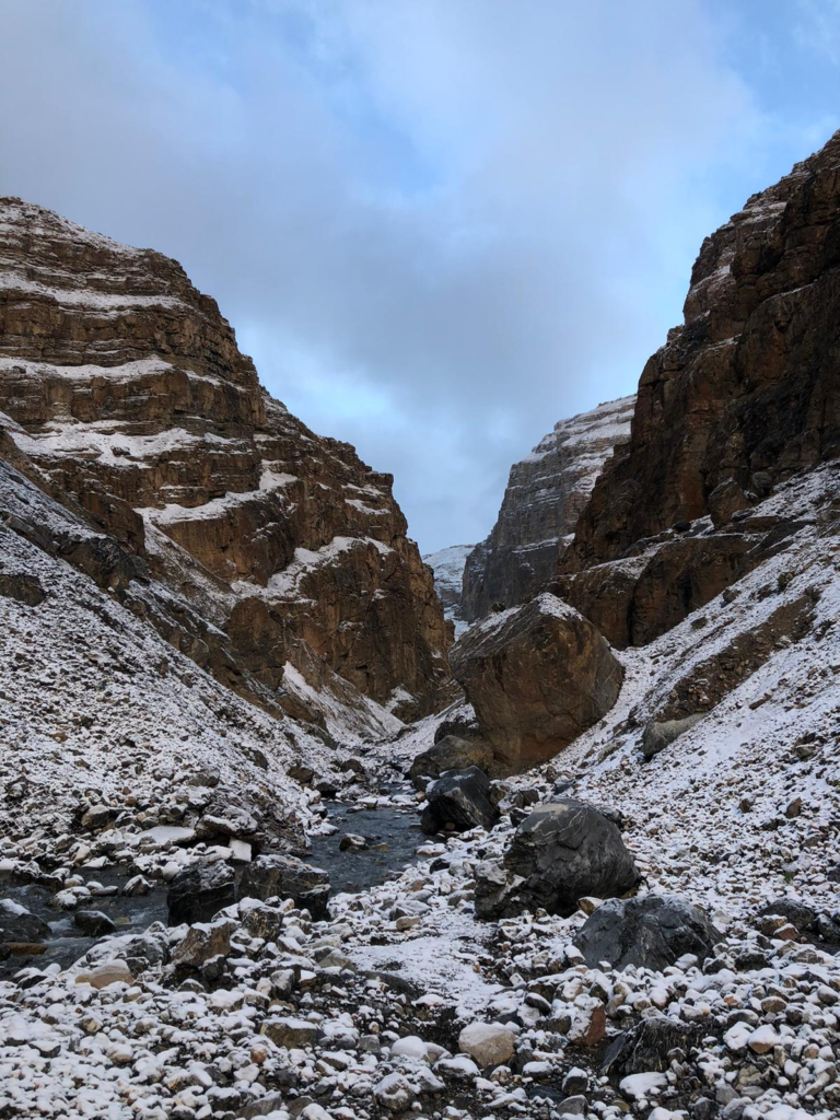
extremely steep river bed to Yulang Dogri, very sketchy, wouldn’t recommend the trail for others
well Im down so thats good, but the next section is extremely steep up
made it! will give you a more detailed recap of those 2 days, whats redoable by others and whats not
[Peter Oct 13]
Please be safe Laurent. Always stick to used trails. Scree slopes can be steep / slippery. Be safe when going solo. Good to see you have network in Spiti
You made significant progress 👍
[Laurent Oct 13]
Im in Leo now! Wanted to go to Hango, but that descent was really rough, I aim for Sunnam through Hango pass tomorrow. I really checked hard for the correct way down, but it is just way too steep, maybe if you were to do a big detour to circle around but I doubt there is real connectivity between those 2 segments. I really checked hard for the correct way down, but it is just way too steep, maybe if you were to do a big detour to circle around but I doubt there is real connectivity between those 2 segments
But the first part (Sumra to Salkhara) is unbelievably beautiful, great trail, just hard visually on the final descent because of 50+ footpaths all going down. But the first part (Sumra to Salkhara) is unbelievably beautiful, great trail, just hard visually on the final descent because of 50+ footpaths all going down
This is the dangerous descent. I didn’t see any trail, just so steep everywhere. In the upper portion to get to the top was the trail you spotted, its just that when the descent starts, there isn’t a trail anywhere, you just scramble on steep scree and hope your legs hold haha
[Laurent 17 Oct]
In Roghi right now, great trail to get to Hango Pass, but steep steep descent with a lot of exposure, would recommend only for really experienced hikers. The river part after,to get to Sunnam, is great. The next pass to get to Lippa village, Runang Be has a clear trail up, but some scrambling on tight edges to get down, again quite technical, not for beginners. The trail right after is beautiful, you have good view over the mountains, but getting down to Lippa was quite a challenge, no clear trails going down so I had to cut through a forest, which took me a long time. From Lippa, the last pass right after Asrang (Kiari We) has a clear trail going up in the village, afterwards its a nice slow climb to the top, physically the easiest in my opinion. The way down though is something else. Joining a lot of small unclear sections of sheperds trail down, and then you have to cut through farms to get to the other side of the river, where the road to Pangi is. Very tiring, but manageable, you have to be creative to find a way.
Now the Spiti Kinnaur traverse is complete, it was a beautiful challenge, especially finding your way down the passes. I believe it could be hiked by others, but they need to be warned of the difficulty as to not get exposed to risk they are not prepared for.
Good! I shipped my stove and pot in Reckong Peo so 1,5 kg lighter now!
[Laurent Oct 20]
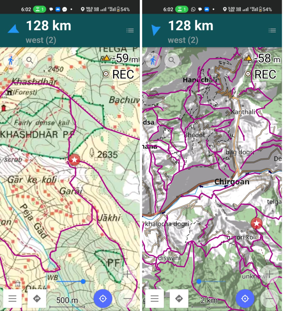
Started from Majhevali today, goingto try and sleep in Kasha tonight. The survey trails are quite hit or miss, the beginning was fine, but the climb became really challenging with the trail being completely overgrown and sometimes disappearing totally. I am on my way down now and couldn’t find the trail, so I have to cut through the forest.
[Laurent Oct 21]
Going to Kathrecht Ghati pass now, a bit of snow on the top of the mountain, but should be able to manage. Locals said it was a hard pass, so I will text you as soon as I am done, should be this afternoon!
[Peter Oct 21]
Just noticed you are trying higher passes than the original traverse (red stars) I suggested. Good to see you are exploring more interior / higher passes. Just be careful in case these are no longer in use by locals and possibly more risky. Glad also you are exploring new Survey trails rather than following already mapped OSM routes
[Laurent Oct 22]
Ok so this was the hardest 15km in my life, started okay with the trail, but it quickly disappeared in the forest, so I had to navigate through dense jungle and thorns to get to the river, crossing was ok, but again no trail from there. I scrambled up a steep steep 200m river bed and stumbled with luck upon the trail at the top, which was not at all at the place SOI indicated. Followed the trail to the top, and then it disappears again, I had to go through dense forest on steep mountain side, taking a lot of risk on cliff sides. After 10h, I decided to camp before the pass, it was too late to push. This morning I followed a tiny section of trail, quickly disappears again and I have to make my way through really steep forest, often climbing my way up, again taking huge risk with big drops battling 7 hours before getting to the beginning of the pass, where it was actually quite easy, even with no trail. Made my way down and now near Rawasi
Considering all of this, and I don’t say this lightly, I honestly could have died yesterday and today, it was survival mode most of the time and I am not ready to take this amount of risk again. That being said, I think we should reroute to lower passes for the rest of the traverse, to make it safer and quicker as well. My next high pass is Pachikanda (4200m), maybe a bit too high? We should chose a lower alternative that is more direct as well. Also, regarding the SOI trails, I found them to be pretty inaccurate and difficult to find in dense forest. I often lose a lot of time finding my way, cutting through dense forest and putting myself at a big injury risk. For all of these reasons, I think it’s better I stick to OSM trail, know trails or SOI trails that are near villages so that i can ask beforehand if the trail is actually still there and safe to take. I also don’t mind having more road sections in the traverse if it means less really isolated SOI trails like the Kathrecht Ghati pass of today. For this pass, I had no real other option to get across, and time is a big factor for me (would like to be in Dharchula in 2 months or less). I love exploring, but safety and quickness are my priorities
[Peter Oct 23]
Understood Laurent. Glad you are safe. I have explored around 3000km of Survey trails and found them to be 90% accurate. Rule #1 is to of course stick to actively used trails – if a trail is no longer in use it ll quickly dissappear in the forest and it’s better to not proceed further given the very steep nature of the Himalayas. The Kathrecht gati trail might no longer be in use by the locals. You ll find many survey trails which are still actively used and which are therefore easy to track and follow without getting into steep / exposed sections
The Kullu 2 Nepal traverse I shared earlier is mostly mapped in OSM by one of my alpine bootcamp students.You can take this as a baseline and try a few Survey trails nearby if they are still in use
[Laurent Oct 25]
I am in Naitwar, near Kedar Kantha, but my right foot swells a bit and hurts on the descent, so I will do a bit less distance and probably take a rest day in Uttarakhand.
Today is actually my first rest day, I pushed through to get to Uttarakashi. It hurts a bit so I am planning to take tomorrow and the day after off and go after that. But the Kullu2Nepal traverse as been going really well, I hesitate way less to find the trail and am able to cover a lot of distance in a day
[Laurent Oct 31]
Took 3 full days off, still feel some discomfort but way less than before. Today was my first day since the break, took it light and did only 20km to reach Sauri. Tomorrow I aim to be in or close to Pinswar
[Peter Nov 1]
After Reeh instead of proceeding to Ghutu you could explore a short new section. From Reeh hike to last village of Gangi and then follow survey trail East up to next ridgeline to Tali where you join the Kinknola pass to Sonprayag. Would be nice to map this section in OSM.
[Laurent Nov 4th]
Ok so in Trijugi Narayan tonight, will be in Okimath tomorrow and then I am thinking of skipping Joshimath and cutting through with Gopeshwar-Garigaon-Agichaura Khal pass-Chanpagna-Mahadev Tal-Kurur-Sitel
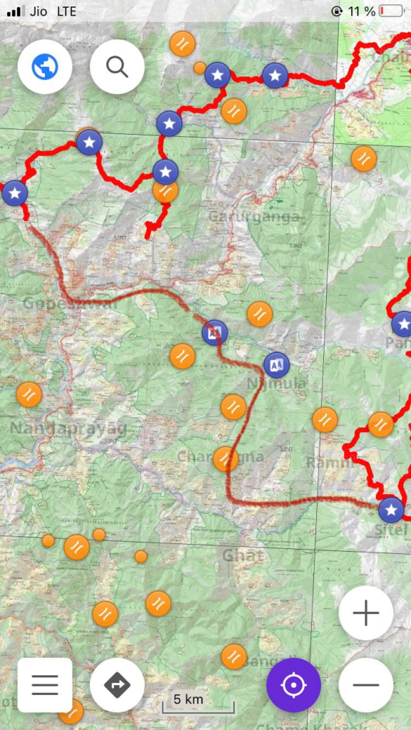
Exploration from Nalaugaon to cut trough to Sonprayag was successful! Beautiful sheperd trail and clear access to the wooden bridge to get there. Overall would recommend, just a big day (24km from Nalaugaon with 1750m up and 2000m down)
[Laurent 5 Nov]
Hmm interesting but I think I want to cut trough the big detour to get to Joshimath through Gargaon SOI trails trough the 2 unexplored mountain passes there and then connect to Sitel
[Laurent Nov 8]
Ok so due to my foot still feeling a bit tender, I decided to cut through Garigaon (flatter section, easier on the foot), Anthruket and then Sitel. I have just a question regarding the last mountain pass before Dharchula, Bhalchidhura Pass, it says on the SOI map that it is open until October. Do you think I will still be able to go through? I estimate being there in 12-13 days
[Laurent Nov 14]
Yes, had no network but I am going to camp after Namik, should be near Mathkot tomorrow! Yes! Some tough days with 2000m+ elevation but trails are beautiful!
[Laurent Nov 21]
Hi Peter! I am in Dharchula (Nepal side) after 2 days needed to cross the border. I had challenging but very rewarding experiences in India and wanted to thank you for the extensive help you provided for me to complete the Indian section of my Himalayan traverse! It now gives me more confidence for the Nepal section, altough no SOI map exists for Nepal, so I have to count on various sources for accurate trail information. The recent earthquake will probably force me to reroute a little south, but I should be able to manage. Once again, thank you very much!
Its true, but the problem in Nepal is the recent law that bans solo trekking in conservation areas and national parks (basically 50% of Nepal and all of the upper sections of the country), so I have to go further south to (1500-3500m) and go around national parks to avoid getting fined or expelled from the country 😅
A cold night in themountains before Balchidhura pass and there was a landslide that makes the normal path to Bona inacessible now, had to do a detour through the road. Apart from that, I wasn’t expecting such a clear and simple to follow stone trail to finish, so I was happily surprised!
[Laurent 20 Dec]
Great actually! I am 2 days away from Kathmandu and will finish my traverse with the 3 passes trek (all 5200m and above) to get to Everest base camp, a nice way to end my journey ! Also sorry for the very late response, the nepali coverage is quite terrible haha. Right now I am at 2100km and I just hit 100 000m of total elevation today!
Yes, the lower altitude mountains of Nepal proved quite the physical challenge, with 2000m+ of elevation almost every day! Also quite hard to navigate the local mountain passes without a detailed map like the SOI, but a lot of fun!
None at all, the locals are very friendly and helpful, but I chose my route not to have any problems. Also won’t need a guide or special permit for the Everest part!
My foot took some time to completely heal, but now I am at 100%. Cardio is also very good and legs/knees feel very solid! I don’t really notice the elevation anymore, even on 2000m+ days, but I will need to re-acclimatize when starting the Everest trek
And of the different cultures and people too! To do such an extensive exploration of the Himalayas was one of the main reasons I decided to do such a project! I will have seen basically all of the biomes of the Himalayas when finished, from the deserts of Ladakh, the tibetan terrain of the border of the Spiti valley, jungles of Uttarakhand and Nepal, and the glaciers and 8000m mountains of Sagarmatha !!
Surprisingly none of the basically unmapped middle districts. The upper provinces (illegal now for me to enter solo due to being national parks / restricted area) are very well mapped though, because they contain the classic touristic trails. I often had to ask locals the way to the passes and moved blindly a few times, but that adds to the adventure!
[Laurent 9 Jan]
I just came back from Everest, had no cell reception there. I finished my traverse a couple of days ago! I had superb weather all the time and am very grateful!