
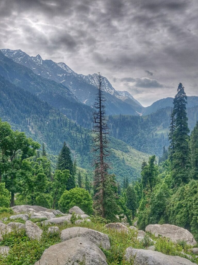
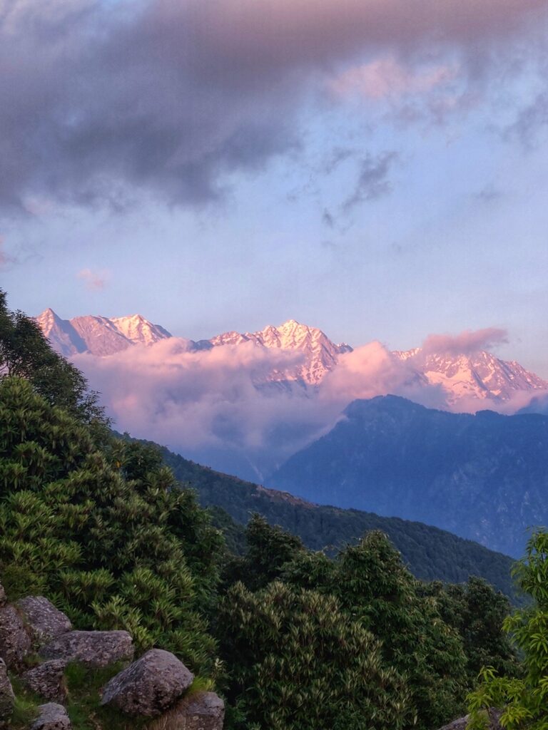
Dharamshala, located at the base of the Dhauladhar is a popular tourist and hiking destination in Kangra district of Himachal. Located at an altitude of 1500m in the foothills the Himalayas rise up steeply to 4000+m separating the Chamba valley in the North from the Kangra plains in the South. Beautiful hiking routes connect crystal clear streams (Khad-s) flowing down through several side-valleys draining snow melt and rain from the upper reaches into the plains.
McLeod Ganj and Dharamkot are popular destinations for foreigners who have extensively explored and mapped the surrounding hills in Open Street Maps. OSM are base maps for the international outdoor community used by independent hikers through many web based and mobile mapping apps. Dharamshala is easily accessible from the plains through overnight bus journey from Delhi. Detailed info on most routes below can be found in separate posts on my blog ultrajourneys.org.
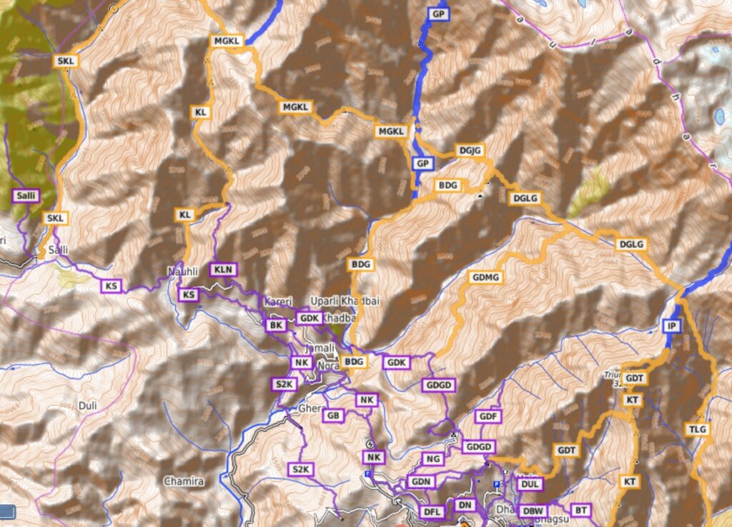
Geography
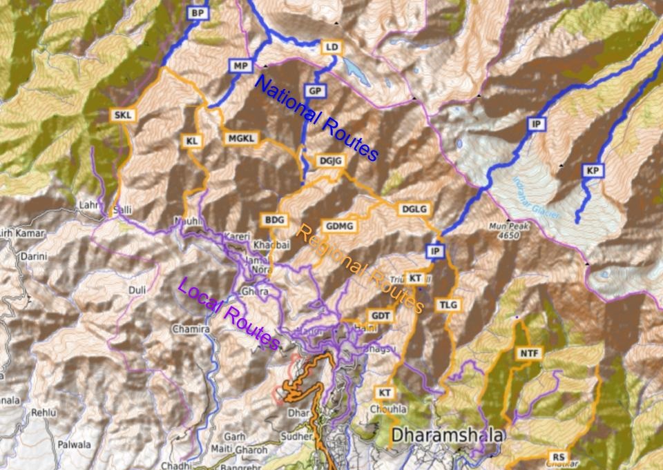
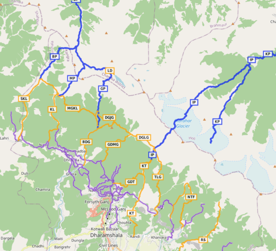
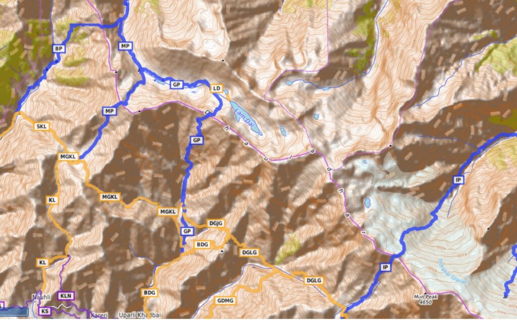
Hiking routes are classified in 3 different networks. Local hikes (purple) in the foothills are perfect for beginners covering smaller distance and less elevation gain (climb) between neighboring villages without the need to carry much food or camping gears. Regional hikes (orange) are day or multi-day routes in the mid-ranges of the Dhauladhar suitable for intermediate hikers touching up to 3000m. National hikes (blue) are high altitude multi-day long distance routes across the Dhauladhar (4000+m) to neighboring Chamba valley requiring good fitness and navigational skills.
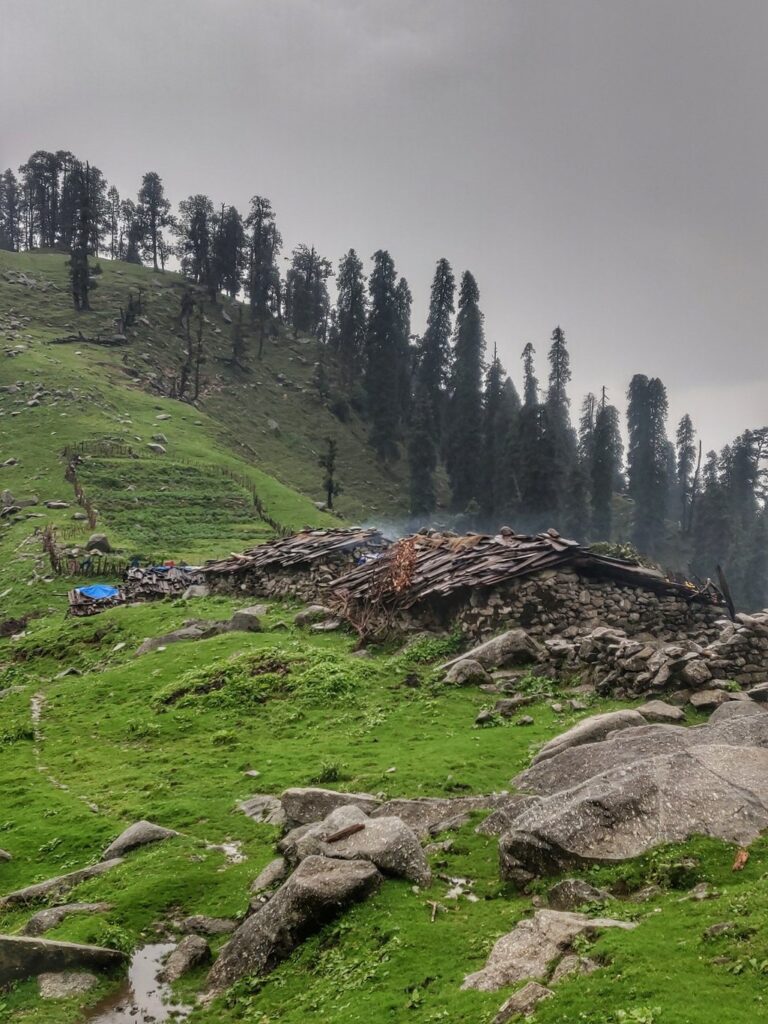
Always plan your hikes per the seasons. Winter snow renders higher altitudes off limits. Local hikes up to 2000-2500m are usually accessible throughout the year. Regional hikes up to 3000m are off limits during winter (Dec-Feb). National hikes touch 4000+m and are open only in summer (June-Sep). Individual routes can be combined into continuous longer traverses / circular loops depending on available time. The foothills are dotted with hamlets and isolated summer dwellings. The mid altitude meadows are grazed by shepherds. So hospitality is never far away.
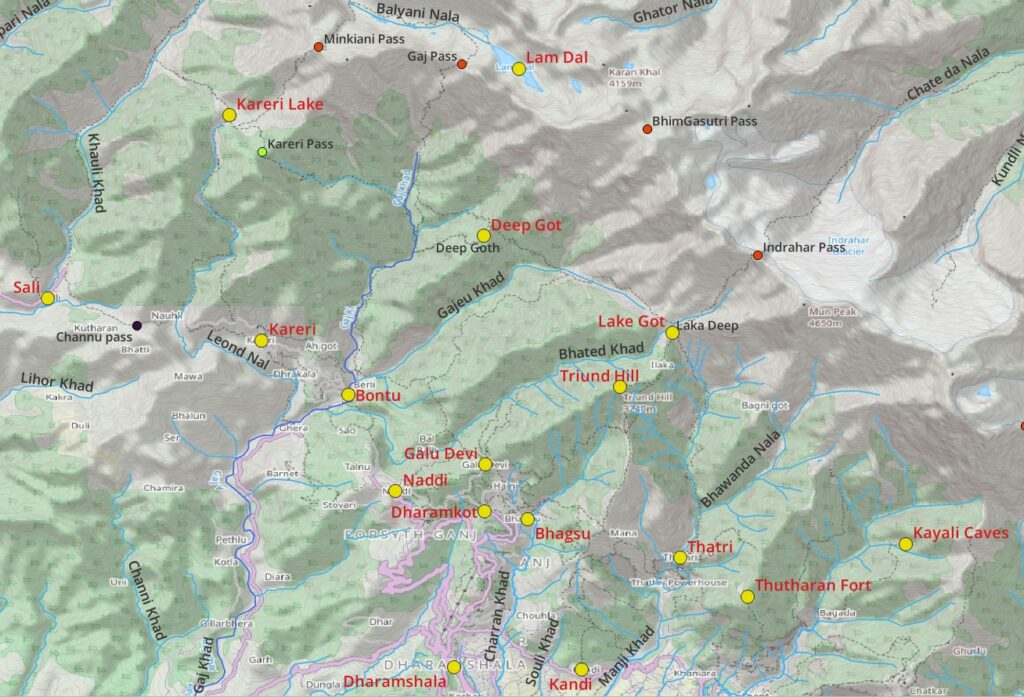
- Local day hikes connect several scenic villages located at the base of the foothills (West to East): Sali, Kareri, Bontu, Naddi, Dharamkot, Bhagsu, Kandi, Thatri.
- Regional hikes take you inside various pristine side-valleys draining the upper reaches (West to East): Khauli Ghad, Leond Nal, Gaj Khad, Gajeu Khad, Bhated Khad, Churan Khad, Manji Khad, Manuni Khad.
- Side-valleys are separated by ridgelines with scenic hiking destinations (West to East): Kareri lake, Deep Got, Lake Got, Thutharan Fort, Kayali Caves, Rising star hill and Himani Chamunda.
- National hikes take you to the upper reaches of the Dhauladhar across several mountain passes into Chamba (West to East): Baleni pass, Minkiani pass, Gaj pass, Indrahar pass and many more further East.
My favorite app to hike the Himalayas is OSMAnd which supports offline OSM base maps, contours, Survey maps and Waymarked Hiking Routes:
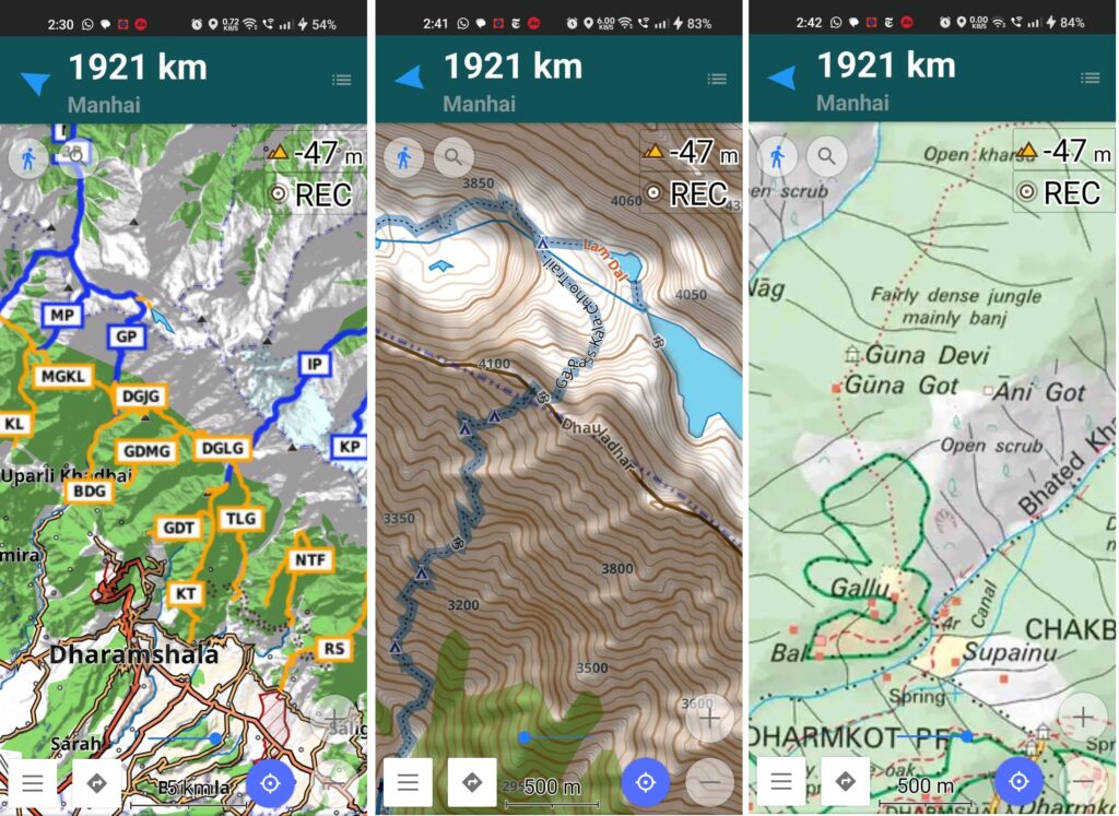
26 Local Hikes around Dharamshala
Short, easy day hikes with limited elevation connecting surrounding hamlets in the foothills of the Dhauladhar perfect for beginners
Central Dharamshala
- Dharamshala to McLeod Ganj (DMLG) – 2.6km / 260m+ a steep foot path above the Churan Khad valley (East of McLeod Ganj) takes you up from Dharamshala (1500m) to McLeod Ganj (1700m) bypassing the hair pin road
- Dharamshala to Dharamkot (DD) – 2.4km / 360m+ an alternative foot path above the Banoi Khad valley (West of McLeod Ganj) from Dharamsala to Dharamkot (1900m) a scenic hill station with lots of homestays & cafes and perfect base for many local and regional hikes
- Dharamkot to Bhagsu (DB) – 2km/ 60m+ a scenic walk from serene Dharamkot (1900m) to more touristic / crowded Bhagsu (1700m)
- Dharamkot to Bhagsu Waterfall (DBW) – 1.4km / 150m+ a short walk along a foot path from Dharamkot to the popular Bhagsu waterfall along the Churan Khad stream flowing down from Triund Hill above
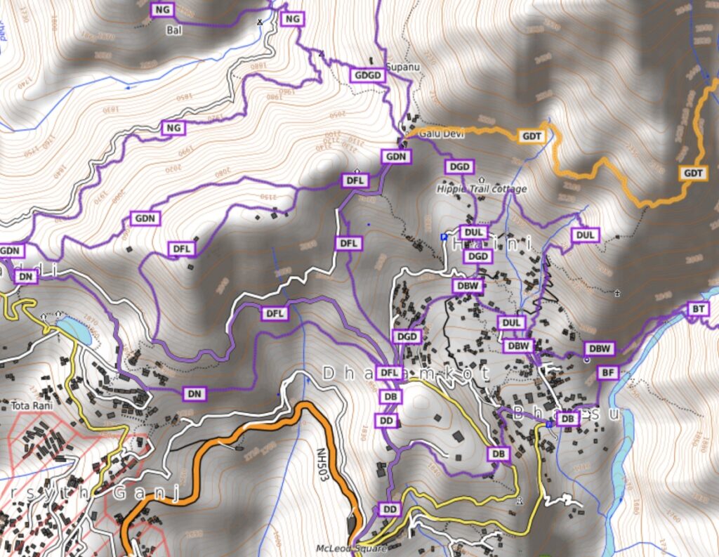
- Dharamkot to Galu Devi (DGD) – 1.5km / 170m+ a short steep hike above Dharamkot to the Galu Devi mandir located on a saddle offering mesmerizing views on both Churan Khad and Bhated Khad valleys
- Dharamkot Forest Loop (DFL) – 4.9km / 380m+ trail circuit which takes you through pristine pine forests to the Nortwest of Dharamkot. Experience peacefulness amid serene nature
- Dharamkot to Naddi (DN) – 2.4km / 160m+ a near flat hike through pine forest from Dharamkot to neighboring hamlet of Naddi from where you get treated on mesmerizing views on the higher snow covered Dhauladhar ranges
- Dharamkot Upper Loop (DUL) – 2.5km / 315m+ a steep hike from Upper Bhagsu to the steep slopes above Dharamkot. Scenic views on the Churan Khad valley
West of Dharamshala
- Galu Devi to Naddi (GDN) – 2.2km / 130m+ a remote forest trail high above the Bhated Khad valley connecting Naddi with Galu Devi. Combined with DGD & DN makes a beautiful circuit around the hillock West of Dharamkot
- Galu Devi to Waterfall (GDF) – 1.8km / 280m+ a short, popular hike from the Galu Devi saddle above Dharamkot through pine forest to a waterfall along the Bhated Khad river
- Galu Devi to Guna Devi (GDGD) – 2.9km / 410m+ scenic footpath from Galu Devi down the Bhated Khad valley, climbing up to Galu village and a foot path to Guna Devi temple with birds eye views on the Gaj Khad valley below. Blog post Blog post 2
- Naddi to Galu (NG) – 3.8km / 310m+ descending from Naddi village into the Bhated Khad valley and climbing up to Galu hamlet
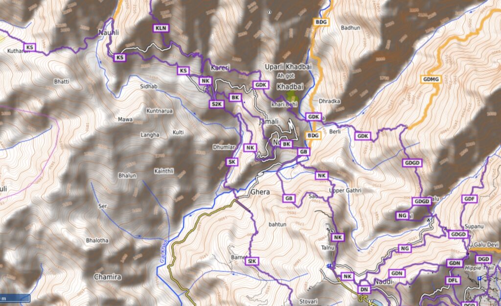
- Naddi to Kareri (NK) – 6.7km / 500m+ a scenic trail from Nadi into the Gaj Khad valley climbing up to Kareri village on the opposite side
- Stovari to Kareri (SK) – 5.4km / 600m+ parallel trail from Stovari hamlet (below Naddi) into the Gaj Khad valley climbing up to Kareri on the opposite slope
- Galu Devi to Kareri (GDK) – 5.2km / 390m+ a beautiful continuation of the GDGD trail into the Gajeu Khad and Gaj Khad river valleys climbing up to Kareri on the opposite side
- Gathri to Bontu (GB) – 2.1km / 100m+ starting mid way the NK trail at Gathri village a trail split takes you to Bontu hamlet in the Gaj Khad river valley
- Bontu to Kareri (BK) – 3.2km / 360m+ climbing up from Bontu in the Gaj Khad valley up to Kareri village along a 4th parallel trail (NK, SK, GDK, BK)
- Kareri to Salli (KS) – 6.6km / 400m+ proceeding further West in the foothills of the Dhauladhar from touristic Kareri to small village of Salli in the Khauli Khad river valley
- Salli to Mandir (Salli) – 3.1km / 910m+ a steep 900m ascent along a ridgeline above Salli village to a small mandir (2600m) offering birds eye views on the Khauli Khad valley below
- Kareri to Leond Nal (KLN) – 3.3km / 770m+ short steep hike from Kareri village into the beautiful Leond Nal river valley flowing down from Kareri lake above
East of Dharamshala
- Bhagsu to Waterfall (BF) – 1km / 210m+ touristic foot path from Bhagsu town to the nearby waterfall along the Churan Khad
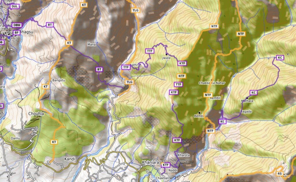
- Bhagsu to Thatri (BT) – 3.9km / 450m+ steep climb out of the Churan Khad across the Triund ridgeline into the Manji Khad valley to the village of Thatri
- Thatri to Thutharan Fort (TTF) – 4.6km / 930m+ steep hike from the Manji Khad valley to the ridgeline above to the ruins of the Thutharan Fort (2600m) offering birds eye view on Dharamshala in the foothills below. Blog post
- Khaniara to Thutharan Fort (KTF) – 4.4km / 1200m+ a steep hike from Khaniara (1500m) in the foothills along the ridgeline between Manji and Manuni Khad river valleys to Thutharan Fort (2600m). Stunning valley views along the entire trail
- Kayali Caves (KC) – 3.8km / 1070m+ climbing up in the Manuni Khad river valley to the Kavalli Caves (2500m)
- Himani Chamunda (HC) – 5.5km / 1335m+ famous pilgrimage. Steep hike from Kand village in the foothills to the Himani Chamunda temple (2900m)
11 Regional Hikes around Dharamshala
Beautiful multi-day medium distance hikes (orange) with more elevation gain for intermediate hikers into the more remote mid-level regions of the Dhauladhar reaching up to 3000m
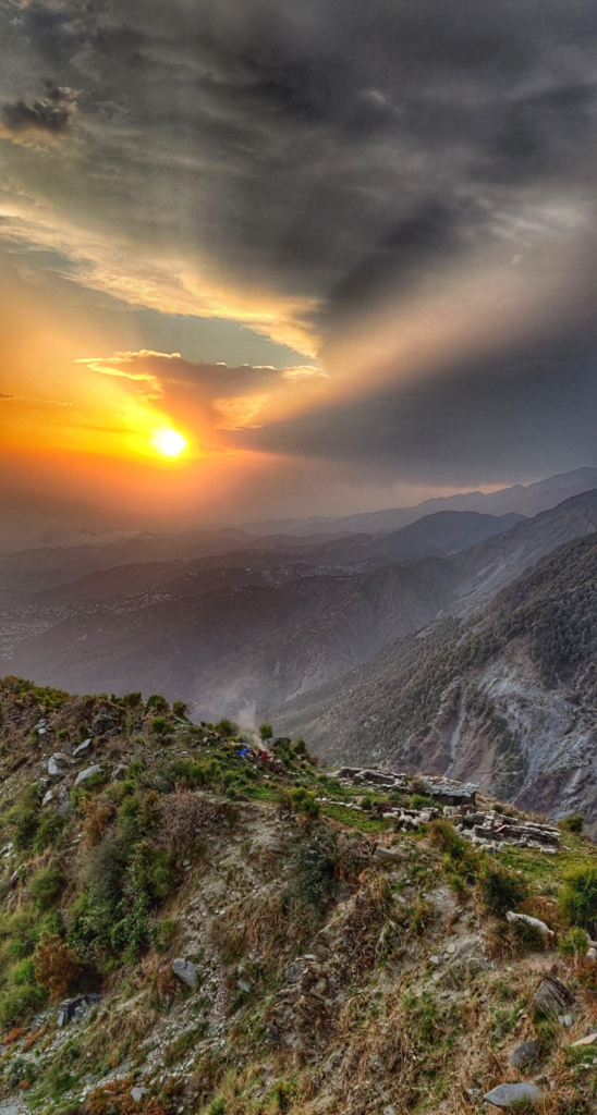
- Triund Hill via Galu Devi (GDT) – 8km / 1300m+ one of the more popular / touristic hikes along a beautiful rock path above Dharamkot high above the Churan Khad valley up to Triund Hill (3240m) offering mesmerizing views on both foothills below and the upper reaches of the Dhauladhar above. Blog post
- Triund Hill via Kandi (KT) – 10km / 2000m+ a 2nd route from Kandi village (1300m) to Triund Hill (3240m) involving a 2000m+ climb along a ridgeline between the Churan and Manji Khad river valleys. Bird eye views all along the trail. Blog post Blog post 2
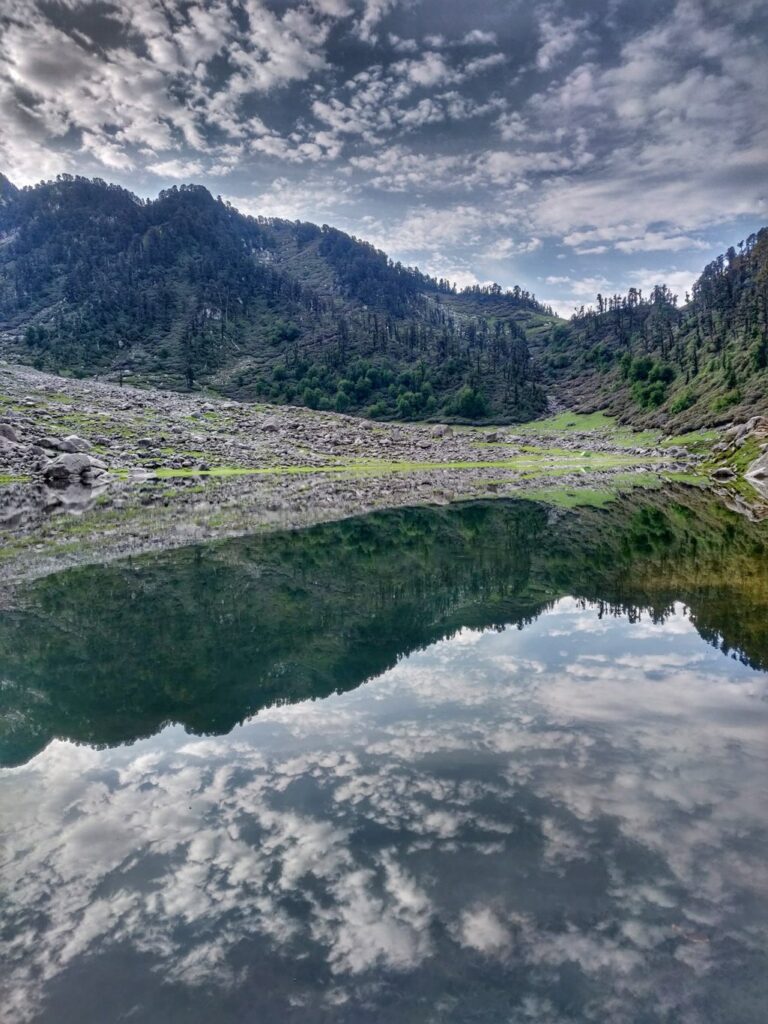
- Kareri Lake via Kareri (KL) – 6km / 1000m+ popular / touristic hike from Kareri village (1800m) through the Leond Nal river valley to Kareri lake (3000m, base of Minkiani pass) offering beautiful views on the upper reaches of the Dhauladhar. Blog post Blog post
- Kareri Lake via Salli (SKL) – 9.4km / 1340m+ 2nd (lesser known, Western approach) route from Salli village through the Khauli Khad river valley to Minkiani summer dwelling (base of Baleni pass) across a saddle to Kareri lake . Blog Post Blog post 2
- Kareri Lake via Matwaru Got (MGKL) – 7.5km / 1030m+ a 3rd (much less known, Eastern approach) route from Matwaru Got a summer dwelling at the base of the Gaj pass in the Gaj Khad along a lesser used trail across a saddle (3100m) to Kareri lake. Blog post Blog post 2 Blog post 3
- Bontu to Deep Got (BDG) – 7km / 1280m+ a very scenic hike through the Gaj Khad river valley from Bontu village to the summer dwelling of Deep Got (3000m) located on a saddle offering mesmerizing views on the surrounding Gaj Khad and Gajeu Khad river valleys as well as upper reaches of Dhauladhar. Blog post Blog post 2 Blog post 3 Blog post 4
- Deep Got to Lake Got (DGLG) – 6.2km / 900m+ a lesser used trail connecting the intermediate saddles of Deep Got (base of Bhimgasutri pass) and Lake Got (base of Indrahar pass). Blog post Blog post 2 Blog post 3
- Guna Devi to Mandrer Got (GDMG) – 5km / 660m+ this remote forest trail high up in the Gajeu Khad valley takes you to the inner regions of the Dhauladhar between Deep Got and Lake Got. Warning – one section is steep / trail less clear. Blog post
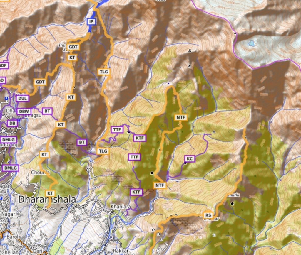
- Tathri to Lake Got (TLG) – 8.6km / 1600m+ a lesser known hiking trail through the pristine Manji Khad river valley through Manhudd steep up to Lake Got at the base of the Indrahar pass. Trail is less clear in some places / good navigation skills required. Blog post Blog post 2
- Naguni to Thutharan Fort (NTF) – 9.7km / 1150m+ from Naguni village gradually climbing up in the Manuni Khad valley to the base of the Kundli pass follow the ridgeline to Thutharan Fort. Mesmerizing views on both Manuni and Manji Khad valleys. Blog post
- Rising Star Hill (RS) – 9.7km / 1900m a steep hike from the foothills to the rising star temple on Chatar peak (2800m). Birds eye views on the foothills below. Blog post Blog post 2
4 Advanced Hikes around Dharamsala
Long multi-day hikes from the mid-regions steep uphill across the upper Dhauladhar into the Chamba valley suitable for more experienced hikers. Requires good navigation skills.
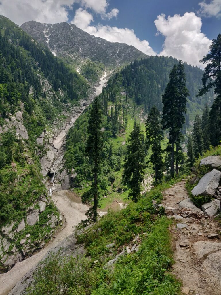
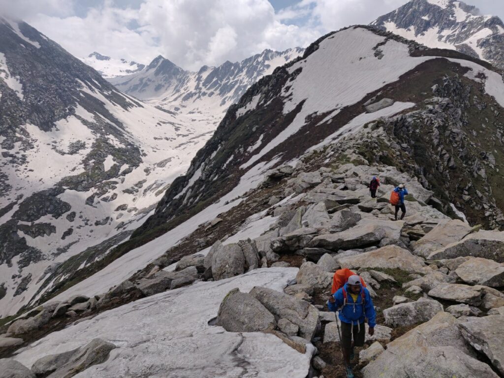
- Indrahar Pass via Triund (IP) – 25km / 1450m+ the most popular pass from Dharamkot to Galu Devi to Triund peak to the top of the Dhauladhar range (4100m) offering mesmerizing views both on Kangra plains (South) and Indrahar glacier, Chamba valley, Pir Panjal range (North). Steep uphill from Dharamkot, gradual downhill to Kuvrasi village in Chamba valley. Blog post Blog post 2
- Baleni Pass via Minkiani (BP) – 21km / 2130m+ lowest pass (3600m) across the Dhauladhar starting from Salli village through the Khauli Khad river valley to Darkund in the Balyani Nala valley in Chamba. Lesser known route but one of the more easy entries into Chamba. Blog post
- Minkiani pass via Kareri Lake (MP) – 19km / 1320m+ a steep 1000m uphill from Kareri lake to the Minkiani pass (4000m) into the Balyani Nala valley in Chamba. Blog post
- Gaj pass via Matwaru Got (via Lam Dal lake) (GP) – 11km / 2000m+ lesser known pass, steep uphill from Matwaru Got / Deep Got along a rock path across the Dhauladhar (4100m) to Lam Dal lake (pilgrimage) in Chamba. Blog post
Read also: