
Recently a friend of mine asked me to suggest a nice 3 day / 2 night Himalayan traverse for him to try his first alpine style hike. To suggest a valid route I asked him which season he was planning. He said he wanted to hike in the month of March. Depending on the winter snow fall, the snowline in March is usually around 3000m so I opened up Waymarked Hiking Trails and looked for available hiking routes in OSM (Open Street Maps) which could be stitched together in a continuous 3 day traverse.
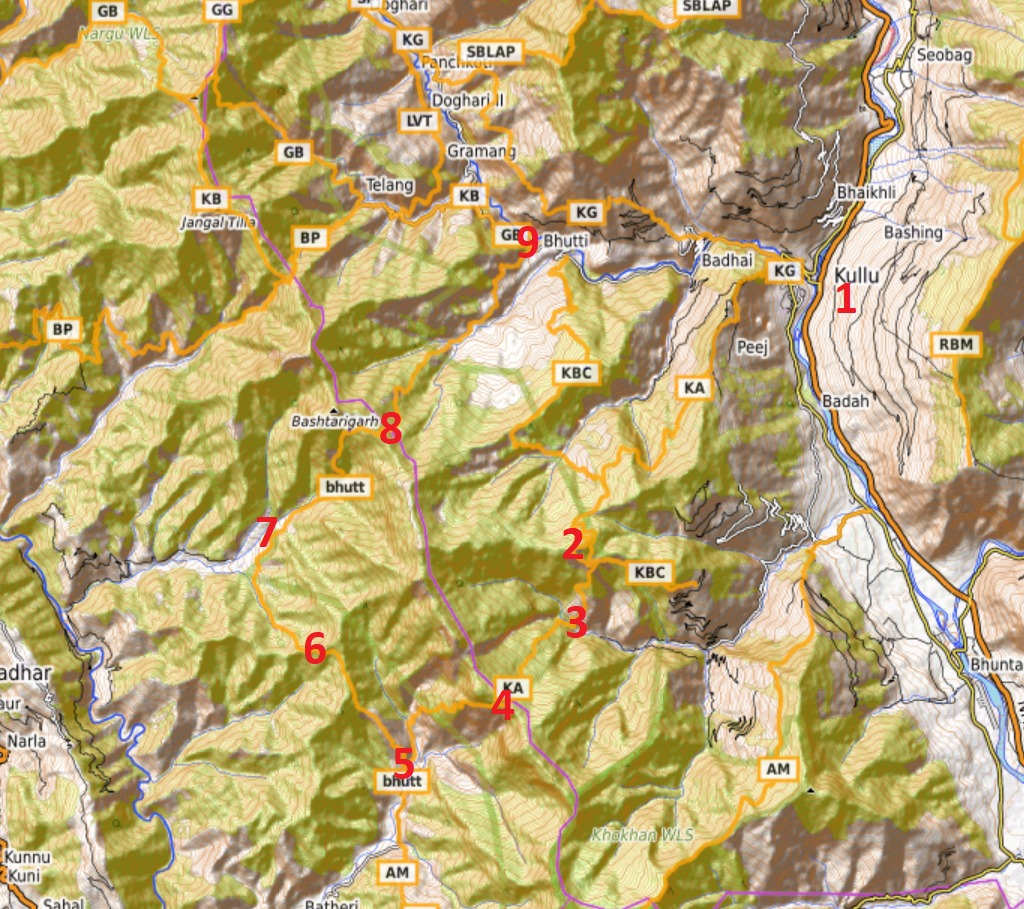
I picked Kullu as a starting point, easily accessible through public transport. I identified 4 passes / 5 valleys which can be combined in a nice 40km circular traverse in the foothills bordering Lug and Barot valleys.
Start at Kullu (Beas valley) – 1
Follow OSM route KA (till Garehar)
Cross over pass 2470m – 2
Descend into side valley of Beas – 3
Bansu village
Climb up to pass 2700m – 4
Descend into Barot valley – 5
Garehar village
Climb over pass 2250m – 6
Follow OSM route bhutt
Descend into Barot valley – 7
Chhuchhal village
Climb over pass 2960m – 8
Descend into Lug Valley
Bhutti village – 9
The same traverse can also be planned through any mobile app which supports OSM basemaps like OSMAnd. Download / import this GPX file in your app to view the above traverse:
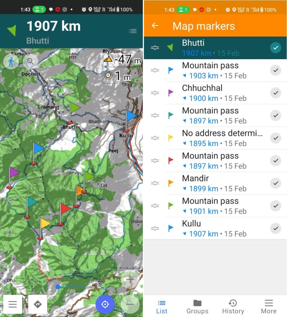
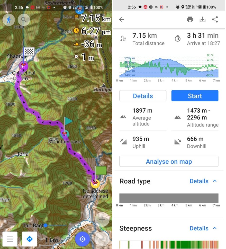
Distance / elevation gain for each individual section (pass crossing) can easily be calculated through OSM routing (hiking mode). Select destination on the basemap in OSMAnd, click Navigation, select a source on the map, click Navigation, make this point of departure. OSMAnd will now route automatically and display the metrics for each section:
Kullu to Bansu – 15km / 1200m+
Bansu to Garehar – 6.5km / 700m+
Garehar to Chhuchal – 7km / 935m+
Chhuchal to Bhutti – 11km / 1400m+
Total – 40km / 4250m+
Slow hikers can target 10K / 1000m+ per day vs. fast hikers can try 20K / 2000m+ per day. In between valleys / villages can be used for food resupply (optimizing your backpack weight, carry sufficient food only till next village). Night halts can be planned anywhere along the route (flat place + drinkable water / stream) before night fall / 6pm. One possible 3 day / 2 night plan could be:
Day 1 – Kullu to Bansu – 15km / 1200m+
Pack 1.5 day food ration at Kullu
Kullu to Bansu, camp at Bansu
Day 2 – Bansu to Chhuchal – 13.5km / 1600m+
Pack 1.5 day food ration at Garehar
Camp at Chhuchal
Day 3 – Chhuchal to Bhutti – 11km / 1400m+
Hitch ride back to Kullu
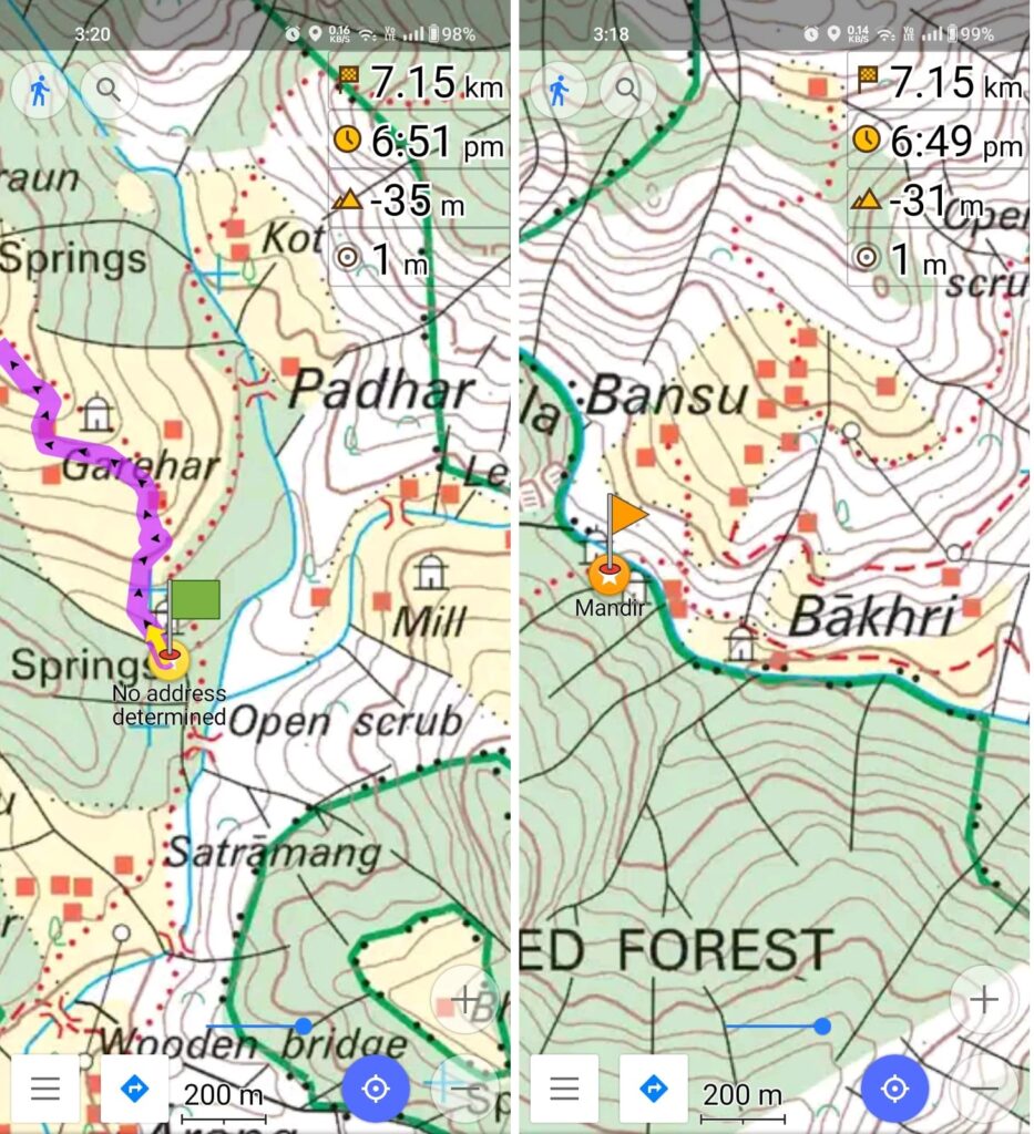
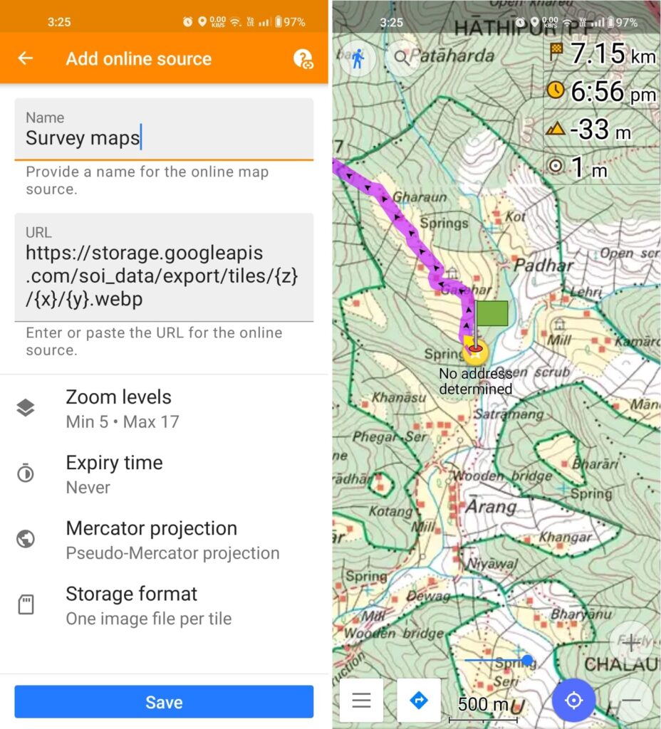
Survey of India maps can be used to reveal additional terrain details – settlements, streams, gullies, shelters, trail splits, bridges, temples, etc allowing for more detailed planning of your journey. To view these simply add a new map source in OSMAnd:
https://storage.googleapis.com/soi_data/export/tiles/{z}/{x}/{y}.webp
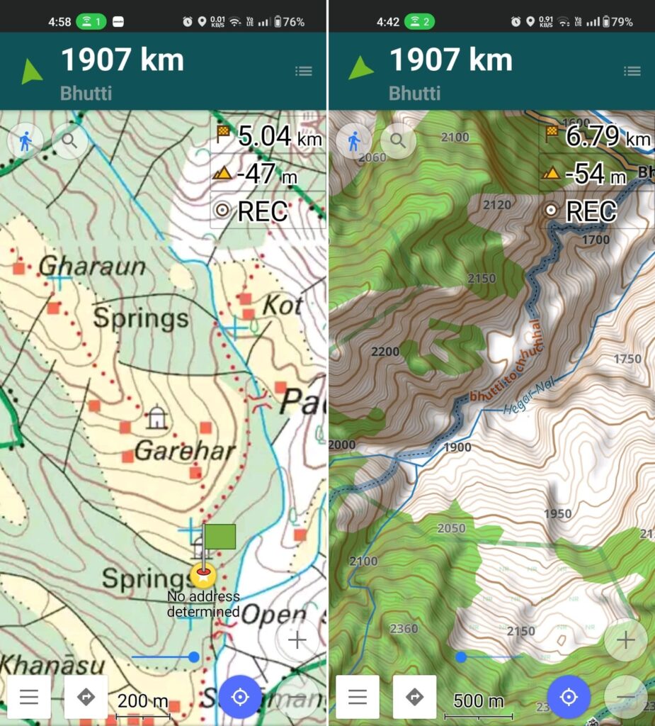
Keep your base map source as “Offline vector maps” and set your overlay map as “Survey Maps” and drag the transparency slider at the bottom of the map window to reveal the most detailed maps of the Himalayas.
Identifying water sources (drinking water) along your route allows you to optimize / minimize your backpack weight (carry just sufficient water till next source). Water is usually found in streams (blue lines on the maps). More water flows lower in the valleys, less water flows higher up near to the ridges / passes. More water flows during spring / summer (winter snow melt, monsoon), less water flows during winter (frozen). More water flows in the afternoon (more snow / glacial melt). You can also find water near settlements and springs (marked on maps).
Suitable campsites are identified as 1. flat spaces along the route where you can pitch up your tent and 2. near to a water source. You can also camp in the valleys near settlements which has several benefits: you can charge your electronics, have dinner / breakfast (no need to carry), warmer nights at lower altitude, safer away from the wild. Or you can decide to camp near the ridges / mountain passes which will treat you on mesmerizing sunsets / sunrises but will be colder nights, less / no water presence and need to carry your dinner.
Dear Peter,
You have always been an inspiration to many. I always hailed you as a Hero.
I appreciate you sharing this detailed Himalayan adventure with me.