
It was raining through the night. Even tough Kirsal was at just 1500m altitude it was really cold. I huddled under the cosy warm blankets in the guest room of my host Bophinder Singh, retired army officer. Sleeping inside a room you don t know when daylight breaks. My host woke me up at 7am with a hot cup of tea.
I went outside to check the weather. Rain had stopped but the sky was still overcast. At least I was glad to get rid of the cold wetness. Bophinder s wife cooked a yummy breakfast – rottis, dhal and spinach sabji. I filled my tummy and thanked my host for his generous hospitality. From Kirsal a path descends in the valley to the road below.
I was hoping to catch a ride to skip the road section but no luck. Not a single vehicle passing by. I skipped a long side loop in the road by climbing down s side valley through a small scenic hamlet. This got me directly to the start of the ridgeline from where I was planning my ascent to climb over from the Ata Gad valley to the Nayar West River valley across a 2900m high ridge.
It had rained a lot the previous night and I could see s good amount of fresh snow deposited at higher altitudes. So I was a bit concerned whether the snow would blank out my trail higher up. There was a small settlement at the start of the ridge from where I followed a path which faded out in the meadows above. A couple of young boys followed me to show me the correct start of the trail.
The trail took me to the village of Majyari at 1800m just below the ridgeline I was following. Locals where building a new road. I followed the trail as per the Survey map which got me to a few isolated homes on top. A friendly elder gentleman showed me the start of the trail. As per OSM there was an isolated dwelling one kilometer further. Beyond that the Survey map trail ended.
To my surprise the dwelling was inhabited. One lady called me and warned me that there was snow higher up which would make my journey more tricky. She insisted I have tea and lunch before heading up.. she gave me a big plate of chaval and yummy gravy. It was around 1pm at 2100m and I had another 800m climb ahead through a snow covered mountain which would impact my pace. It was high time to move ahead.
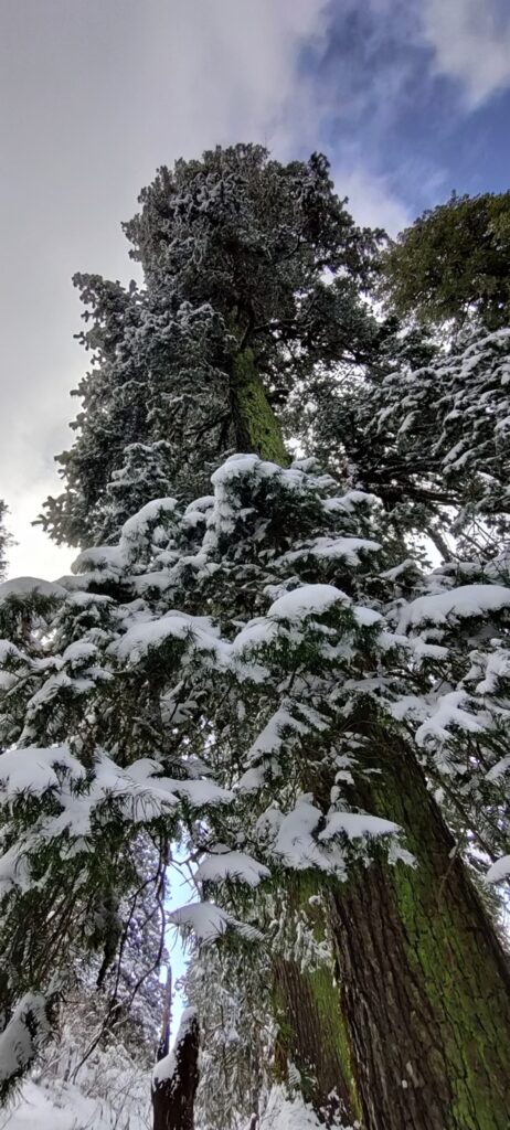
A less frequented but clear trail followed the top of the ridgeline. Very soon snow appeared and I had to be alert not to lose track of my trail below the white blanket. Somehow I could figure out the direction by the clearing in the forest and the flatness of the trail. The amount of snow increased as I was making my way up. The mid day sun was melting the snow from the trees above.
To my surprise it was pretty straightforward to stay on track. A piece of my mind as I was really worried about losing track and getting stuck in vegetation and a fairly steep slope. A bad combination without a proper trail to walk on. Near the top the trail contoured around the peak at 2900m. Shoes were sinking half a feet inside the snow.
Near the other side of the top ridgeline there was an isolated dwelling covered in snow. From here the trail drops down into the opposite valley as per the Survey map. I lost the actual trail beneath the thick snow blanket and made my way down using my offline contour map. Further down there was another deserted dwelling with s small mandir at the confluence of two small streams.
The isolated settlement covered in a white snow blanket made a beautiful sight to behold. From here the path got upto a small ridgeline and was partly appearing from beneath the snow. I was back on the right track. I spotted another dwelling further down on OSM and discovered a third settlement now with lesser snow.
From here I could see s clear path down a neighbouring ridge to get me down to a deserted road in the valley below. A couple of local ladies were climbing up and surprised to see me coming down. I hit the road and with no vehicle to be seen followed it as it contoured into the valley below to the village of Tarpalisain. It s s main road site travel hub with many shops and dhabas.

It s located on the main road connecting the West and East Nayar river valleys separated by small pass. Plan was to settle down here for the night and take an early morning taxi to the East Nayar valley from where I would cross over to Gairsain. I had two plates of super tasty fried veg mommo’s. A true delicasy after a 30km hike with 1800m elevation gain.
With no power in the village I could not charge my phone. After dinner I pitched up my tent on the empty grounds of the closed school of Tarpalisain. Temperature wwas dropping fast in the windy valley at 1800m. The sky was still overcast. I was praying to get my blue sunny skies back soon which I had been enjoying the last 3 months.
Trans Hima 2020 – 68 Kirsal to Tarpalisain It was raining through the night. Even tough Kirsal was at just 1500m…
Posted by Peter Van Geit on Saturday, 20 February 2021