

The Himalaya stretch out across a vast region spanning many countries from Arunachal in the Southeast to Tian Shan in the North. In this post we present a multi-year trans Himalaya traverse over 8.6 thousand kms across 6 countries. Note that this only covers a logical hiking route, we additionally need to plan for seasons (monsoon, winter snow) and physical access (VISAs, permits). At a daily mileage of 20km it would take 1.5 years to complete this traverse.
- Countries
- Seasons
- Possible Timelines
- Sections
Countries
- Arunachal – 1000km
- Bhutan – 500km
- Sikkim – 150km
- Nepal GHT – 2000km
- Western Indian Himalayas – 1100km
- Pakistan Karakoram – 700km
- Afghanistan – 200km
- Tajikistan – 1000km
- Kyrgyzstan – 2000km
- Feiniao China – 1500km
- Total – 8600 km
Seasons

| Country | Altitude | Season | Traverse | Traverse Months | Avoid |
| Arunachal | 2000-4000m | Mar-May Oct-Nov | 1000km (2 months) | Mar-Apr | Jun-Sep (monsoon) |
| Bhutan | 2000-4000m | Mar-May Late Sep-Nov | 500km (1 month) | May | Jul-Aug (monsoon) |
| Sikkim | 250km (2 weeks) | May | Jul-Aug (monsoon) | ||
| Nepal (high) | 3000-6000m | Apr-Jun Sep-Nov | 2000km (4 months) | Recommended: May-Sep West to East | Jul-Aug (monsoon) Dec-Feb (snow) |
| Nepal (mid) | 1000-3000m | Oct-Apr | 2000km (4 months) | Jul-Aug (monsoon) | |
| Uttarakhand (high) | 5000-6000m | Late May-Early Jul Mid-Sep Mid-Oct | 700km (1 month) | Late May-Early Jul | Jul-Aug (monsoon) Nov-Mar (snow) |
| Uttarakhand (mid) | Sub 4000m | May-Early Jul Sep-Oct | 700km (1 month) | May-Jun or: Oct-Nov | Jul-Aug (monsoon) |
| Ladakh/Kashmir | 4000-5000m | mid Jun-mid Sep | 500km (1 month) | Jul-Aug or: Aug-Sep | Nov-Apr (winter) |
| Total | 6350km (10 months) |
Possible Timelines

- South sections are off limits during Monsoon (Jul-Aug)
- High altitude sections closed during winter snow (Dec-Feb)
Possible timelines:
- Arunachal-Bhutan-Sikkim – Mar to May
- Nepal(high) West to East – May to Sep
- Uttarakhand(high)-Ladakh-Kashmir – Jun to Sep
- Kashmir-Ladakh-Uttarakhand(mid)-Nepal (mid) – Jul to Jan
- Uttarakhand (mid)-Ladakh-Kashmir – May to Sep
- 1+3 can be combined in one year Mar-May and Jun-Sep
Arunachal

A 1000km trans Arunachal traverse over 18 passes and 19 major valleys through multiple alternate routes mapped using Survey 1:25K and 1:50K maps. These are mostly lower altitude routes close to the India-Tibet border (sub-4000m) progressing from Myanmar in the East to Bhutan in the West. This mid range traverse should be open during April-Nov excluding the Jun-Aug monsoon.

Bhutan

A 500km long mid altitude traverse through Bhutan from Tawang in Arunachal to Gangtok in Sikkim over 8 passes and many valleys via a mid range (sub 4000m) route. Best season is Apr-Oct excluding the monsoon in Jun-Aug. Note – special permissions would be applicable for hiking in Bhutan.
Sikkim

A 150km long traverse connecting Bhutan in the East (Tendu) with Nepal in the West (Sandakpu). Planned partly using 1:50K Survey maps and partly Open Street Maps.
Nepal GHT

Better known as the Great Himalayan Trail (GHT) traversing the entire length of Nepal East to West across 2500km. This is a mostly high altitude route (4-6000m) close to the border with Tibet in the North requiring permissions and (probably) mandatory local guide. Alternatively we can also look at a less restricted / mid altitude traverse across Nepal using 1:25K and 1:50K topo sheets. Season is Apr-Nov excluding the monsoon months of Jun-Aug. Higher passes will be cold / closed during winter Dec-Mar.

Western Indian Himalayas

A 1100km traverse from the border of Nepal across mid and high altitude (4-6000m) passes through Uttarakhand, Himachal, Ladakh and Kashmir. As we go further North note that some high altitude passes will only be open during June-October. Monsoon (July-Aug) should be avoided in Uttarakhand and Himachal. Special permission and mandatory guides apply for most high altitude passes in Uttarakhand.
Alternative we can also look for a mid-altitude traverse of Uttarakhand (open May-Nov, excl. monsoon). There are many alternate routes possible through Ladakh.

Pakistan Karakoram

The Karakoram in Pakistan has a vast 8000km trail network across 200 passes (digitized through Soviet 1:100K topo sheets). From this network we can derive several Southeast to Northwest traverses from the border of India to the border of Afghanistan (around 700km). Special permissions might apply to hike in this region. Located further North most of these high altitude glacial traverses would be best to hike during summer month (Jun-Sep).
Afghanistan

The Afghanistan Himalayas is a narrow corridor between Pakistan and Kyrgyzstan consisting of high altitude glacial ranges. This particular region has not been mapped yet. One can use Soviet 1:100K topo sheets to identify a sizeable trail network (black dashed lines below) across this region to proceed further North across the Himalayas. As we go further up North the season to cross this section would be best during summer. Safety issues might exist given the recent clashes between the Afghanistan Taliban and Pakistan army.

Tajikistan

Tajikistan spans a vast area over the Himalayas between Afghanistan in the South and Kyrgyzstan in the North. A good number of trails in Tajikistan are mapped in OSM (see below). Additionally the Soviet 1:100K topo sheets (further betlow) hold a vast trail network for the region. Best season for these glacial traverses further North would be during summer. We recently mapped The 1400km Pamir trail in Tajikistan in OSM:


Kyrgyzstan

A 2000km long West-East mid-range (2-4000m) trans Kyrgyzstan traverse was done by Jeremy Bige in 2018 from North Tajikistan to Karakol in the North detailed in this post. Best season for this Northern traverse would be June to October as winters would be very cold. We recently mapped this trail in OSM:
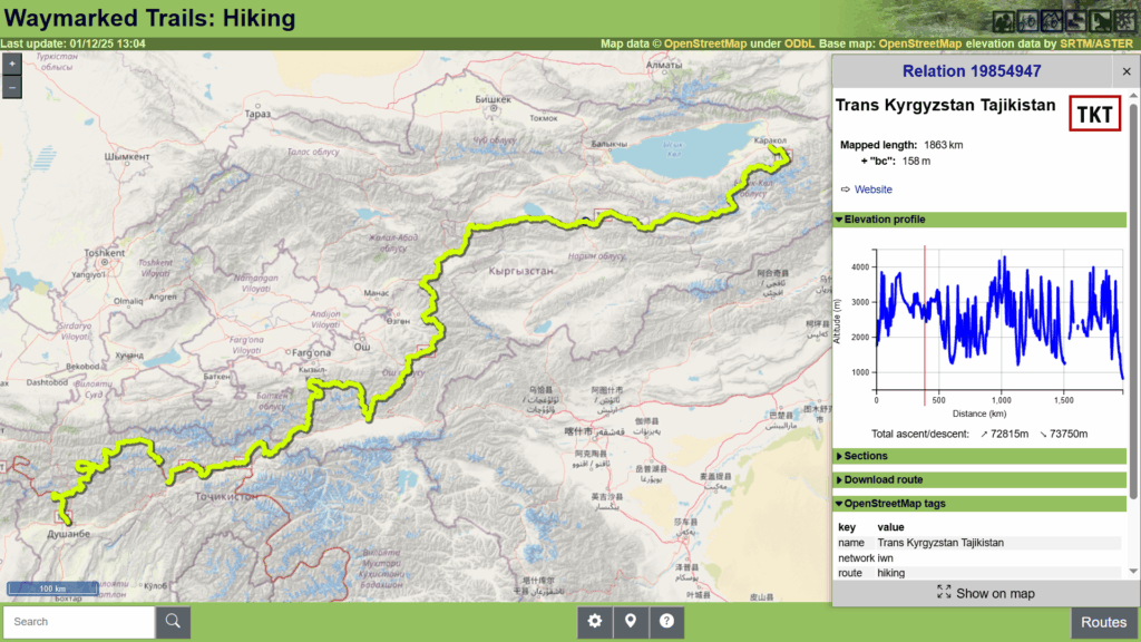
A fairly large number of trails are mapped in OSM (see below) in addition to a vast network of trails which can be found on the Soviet 1:100K topo sheets (further below).


Feiniao, China

Proceeding further Northeast from Kyrgyzstan we enter North Tibet where we finish our trans Himalaya traverse with a 2000km circuit across the Feiniao range mostly lower altitude (2-4000m). Best season would be during summer June-Oct. Recently mapped in OSM here.
