

1. Introduction
In this blog post we guide you on how to plan a long distance hiking trail through the mountains. We use the Nepal Himalayas as an example. To plan a traverse we use a number of important resources
- Geography / Rivers
- Mountain passes
- OSM Hiking Routes
- OSM trails
- Nepal topo sheets
Geography / Rivers
The geography of a country is defined by the rivers (valleys) that flow through it. While planning a traverse across Nepal we keep hopping across 50 major river valleys while traversing the length of the country (OSM tag: waterway=river)


Mountain Passes
Mountain passes allow us to hop across mountain ranges / ridgelines in between valleys. Using legacy topo sheets we mapped 2000+ passes across Nepal offering infinite ways to traverse the country. (OSM key: mountain_pass)


OSM Hiking Routes
Hundred+ hiking routes are mapped in OSM spanning the length of Nepal (continental/red, national/blue, regional/orange, OSM tag: route=hiking). These accurate GPS recorded routes allow us to create traverses connecting individual sections


OSM Trails
Additionally thousands of smaller trails are mapped in OSM offering additional regional paths which can be connected in longer traverses. (yellow lines, tag: OSM highway=path)

Nepal Topo Sheets
Detailed 1:25K and 1:50K topographic sheets can be downloaded for the entire country showing topography, terrain, remote settlements and interconnecting trails


2. Traverse Planning
Planning a trans Himalayan traverse is about identifying a continuous long distance route through the mountains with regular in-between stops (villages) for food supply. A simple-yet-powerful web based tool to do so is nakarte.me allowing us to view:
- Geography / Rivers
- OSM Hiking Routes
- OSM trails
- Topo sheet trails
- Mountain passes
Geography / Major Rivers
To plan a trans Himalayan traverse it’s important to understand the overall topography or geography of a region including major rivers / valleys draining its snow covered high ranges. Use Custom Layer to view an elevation profile with major valleys in nakarte.me: https://indianopenmaps.fly.dev/ultrajourneys/altitude/himalayas/{z}/{x}/{y}.jpg

OSM Hiking Routes
OSM Hiking Routes are an established course of travel along a set of ways between destinations. Individual hiking routes can be connected to form long distance traverses. Use Base layer mapy.cz to view hiking routes at scale 3km or create an Overlay tile layer: https://tile.waymarkedtrails.org/hiking/{z}/{x}/{y}.png


OSM Trails
OSM Trails are smaller local hiking trails which can also be combined along with OSM Hiking Routes as part of a long traverse. Use base tile layer: mapy.cz tourist to see OSM trails at scale 500m or lower.

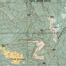
Nepal Topo Sheets
OSM Hiking Routes and Trails are preferred to plan a traverse as these are more recent / accurate / GPS mapped trails. In regions where the above are not available we can make use of legacy 1:50K and 1:25K scale topo sheets to identify trails which are yet unmapped in OSM. Base tile layer: https://indianopenmaps.fly.dev/nepal/topo/maze/main/{z}/{x}/{y}.webp. Trails are shown as red dashed lines.

OSM Mountain Passes
Open Street Maps and Legacy topo maps offer thousands of kilometers of trails which can be interconnected into long distance traverses across the Himalayas. This vast network of trails can be overwhelming and challenging to choose from. To guide the user we overlay OSM mountain passes over a topographic base map which guide us how to connect neighboring valleys across in-between mountain ranges or ridgelines:


Say we wish to hike from Modi Khola to Seti Khola to Madi Khola to Midim Khola. Mountain passes clearly show us where hiking routes cross over in-between ridges connecting these valleys. Depending on the season (snowline) we can either choose higher (summer) or lower (winter) altitude passes to get across. We prefer choosing OSM hiking routes or trails which are accurate GPS mapped trails:

Where no routes or trails are mapped in OSM we can fall back to legacy topo sheets to explore and map new trails connecting neighboring valleys and ridges:

3. A Sample Traverse
Below is a sample Himalayan traverse spanning the length of Nepal. We use three different categories:
- Traverse villages (blue) – identifying in-between villages for food supply / night stay
- Traverse passes (red) – mountain passes along the traverse connecting neighboring valleys
- Traverse trail points (yellow) – regular distance points marking the OSM or legacy trails to be followed
The above GPX files can be downloaded into nakarte.me to view the trans Himalayan traverse across Nepal.

Two sample traverses are mapped:
- A high altitude traverse following OSM hiking routes (blue/national) which mostly require permits (and mandatory guides). Passes (red) and in-between villages (blue) are marked.
- A mid altitude traverse following mostly legacy trails (yellow markers) with in-between villages (blue) marked as food stops.

Western Nepal

Central Nepal

Eastern Nepal
