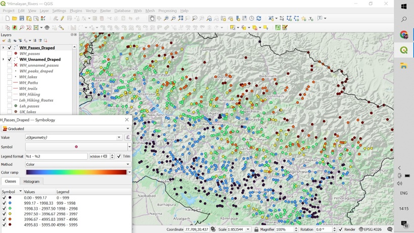
While planning a traverse through the Himalayas we need to take into account the seasons. During winter the snowline descends to 2-2500m altitude, in spring it retreats till 3-3500m and during peak summer we can scale the high passes at 4-5000m altitude without sinking too deep into the snow.
Above QGIS screen shows mountain passes in Uttarakhand extracted from Open Street Maps (OSM) visualized using a graduated color spectrum as per elevation (extracted from SRTM DEM). Blue (2000m) passes can be hiked during winter (Jan-Feb), green (3000m) passes should be doable in spring (Apr-May), yellow (4000m) in early summer (June-July) and red (5000m) in summer (Aug-Sep).
Named (1500) and unnamed (1200) passes for the Western Himalayas extracted from OSM can be downloaded here (files: WH_passes_*.gpx. WH_passes_unnamed_*.gpx). Select the files as per the elevation range. You can directly import these GPX files in your favorite mapping app.
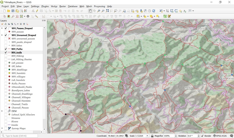
Once we download a suitable set of passes in any given season, we can simply “connect the dots” using digitized paths and trails from the Survey of India maps available over here (files: HP, UK, LD, JK_trails.gpx/paths.gpx). There are more than 63 thousand kms of Survey trails which can be explored across the Indian Western Himalayas.
Above QGIS view shows Survey paths and trails rendered on a Thunderforest Landscape topographic OSM basemap for the Uttarkashi district in Uttarakhand. These connect neighboring valleys and ridgelines through mountain passes accessible as per the season (elevation, color). Same GPX files can be imported in your favorite mapping app and mark / flag a continuous traverse.
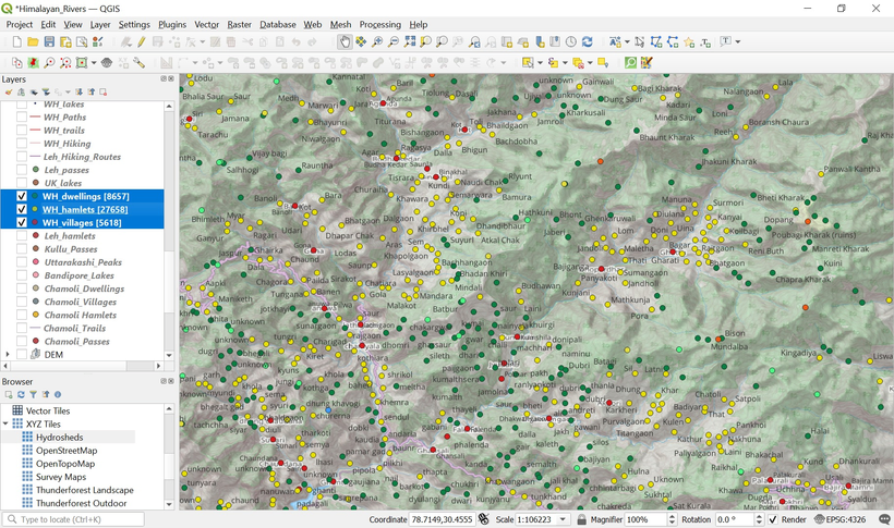
Once we create a continuous traverse connecting multiple mountain passes we can identify human settlements along the way which will provide useful stops for food supply and night halt. This allow us to optimize our ration enabling us to traverse lighter and faster through the mountains. More than 40 thousand settlements across the Western Himalayas have been mapped in OSM and appear as we zoom in further into any mapping app.
Above QGIS view shows the villages (red), hamlets (yellow) and dwellings (green) for the Tehri Garhwal district of Uttarakhand. Villages are larger settlements with basic facilities (admin, medical, school) usually connected by road. Hamlets are smaller farming settlements higher up the valley slopes usually connected by trails. Dwellings are more isolated, seasonal settlements typically at higher altitude usually only inhabited during summers.
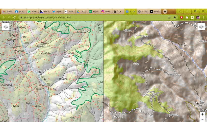
More terrain details of our planned traverse can be seen in Survey of India maps in a plain web browser above:
- Terrain: cultivations (yellow), forests (green), glaciers (light blue), lakes (blue), moraines (black dots), meadows (Thach, Bhugyal)
- Settlements (red squares), urban areas (red polygon)
- Rivers & streams (blue lines, Nala) and gullies (black lines)
- Trails (red dotted) and paths (red dashed lines)
- Ridgelines (black double dotted lines, Dhar)
- Springs (blue cross) and water falls (blue line)
- Boundaries (thick red, black dotted)
- Mountain passes (black X) + opening season
- Mountain peaks (Jot, Tibba)
- Bridges and ropeways
- Temples (white symbol)
Survey maps suitable for offline navigation in your favorite mapping app can be downloaded Patreon (advanced subscription).
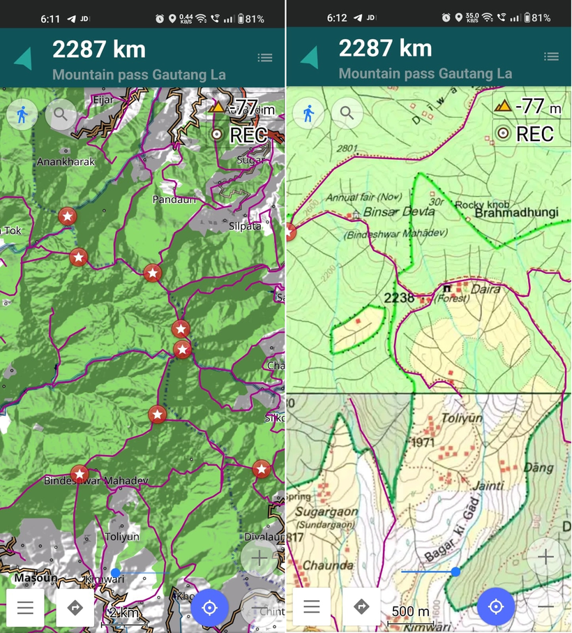
Finally, we can download OSM basemaps, contours (topography), mountain passes (elevation range), digitized trails and paths and even Survey map tiles on our phone suitable for offline navigation in the mountains – refer above. My favorite mobile planning and navigation app is OSMAnd which works well with large maps and digitized data of entire Himalayan states.
Vector data (OSM, digitized trails – left view) is useful for planning traverses at higher scales. Bitmap data (Survey maps – right view) and contours are useful for day-to-day navigation at lower scales bringing out individual terrain details and topography.
