Skip to content
UltraJourneys

Author: Peter Van Geit

  • Home
  • Blog
  • About
    • Profile
    • Social Media
      • Substack
      • Instagram
      • Whatsapp
      • Patreon
      • YouTube
      • Facebook
    • Articles
      • Blogs
      • The Himalayan Club
      • ExplorersWeb
      • Outdoor Journal
      • IMF
    • Interviews
    • News
    • Talks
      • Colleges
      • Corporate
      • Public
      • TEDX
    • Awards
    • Relief
  • Online Courses
    • Field Bootcamp
    • Online Bootcamp
    • Alpine Webinar
    • Navigation Bootcamp
    • GIS
    • Minimalist Gears
    • Himalayan Regions
    • Sahyadri Regions
    • Self Supported Runs
    • Running in Vietnam
    • GIS Workshop
    • Social Media
  • Himalayas
    • Mapping the Himalayas
    • Guiding Hikers
    • Himalayan Regions
    • Gears
    • Traverse Planning
    • Nepal
    • Alpine Lakes
    • Cycle Touring
    • Ultra Running
  • Maps
    • Himalayan Maps
    • Himalayan Traverses
    • Open Street Maps
    • Journey Maps
    • Survey of India
    • Navigation
    • Topography
  • Journeys
    • EuroVelo 8 2025
    • J&K 2022
    • Himachal 2021
    • Uttarakhand 2021
    • Trans Sahyadri 2019
    • Trans Himalaya 2019
    • Trans Sahyadri 2018
    • Trans Himachal 2018
    • Vietnam 2018
    • Spiti-Pangi 2017
    • Ultras 2017
    • Pangi-Zanskar 2016
    • Vietnam 2016
    • Pangi 2015
    • Spiti 2015
    • Srilanka 2015
    • Shimla-Leh 2013
  • Sitemap

Alpine Hiking 8E – Analysis

December 31, 2021 Peter Van Geit

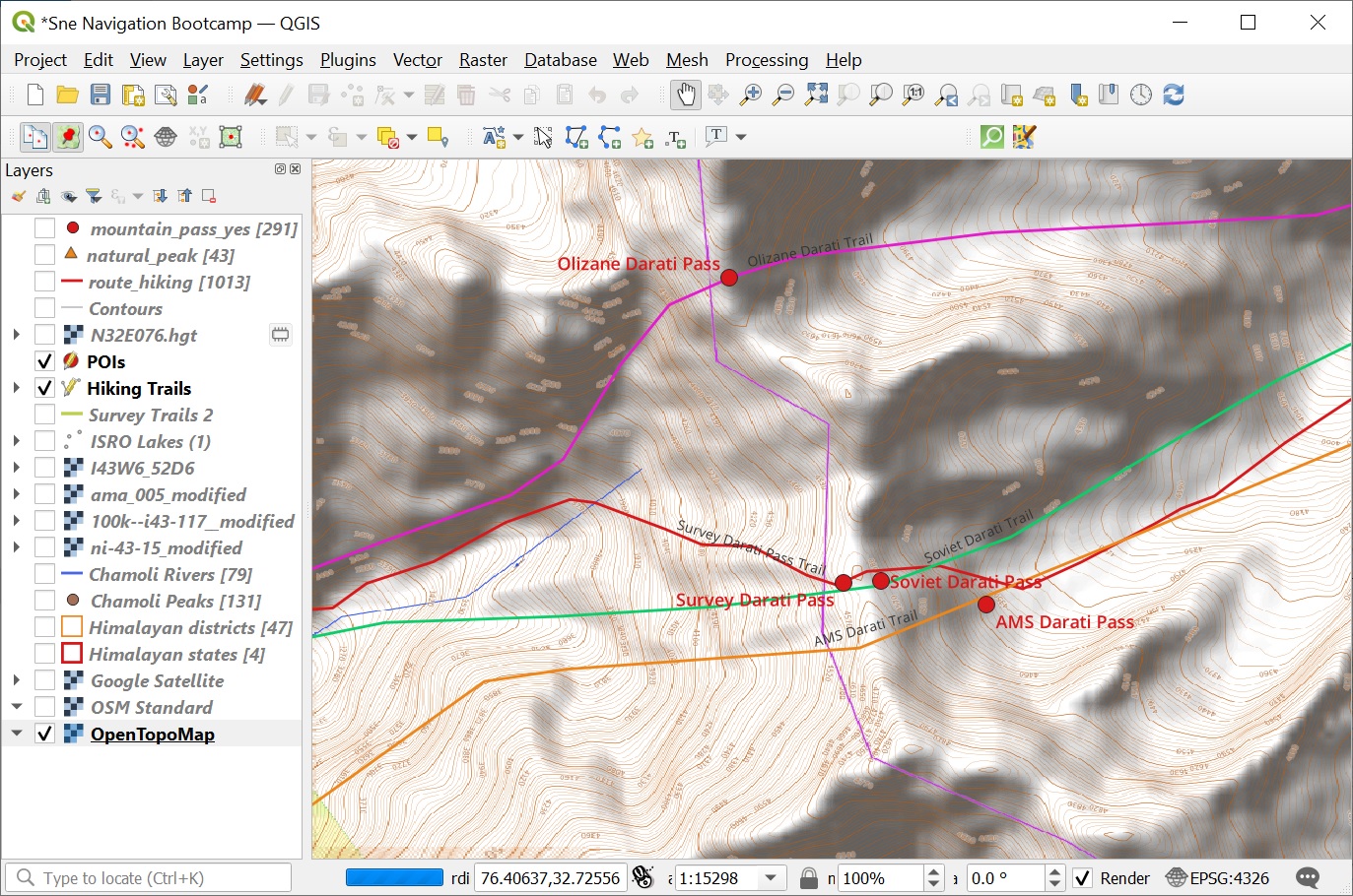
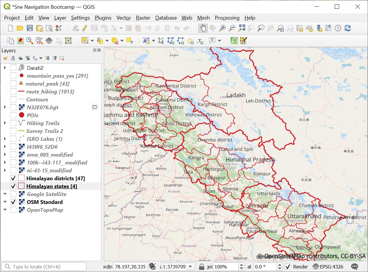
In this final module we ll be cross referencing the digitized features of Survey, Olizane, Soviet and US AMS maps…

Continue Reading →

Posted in: 8 Maps of the Himalayas, Alpine Bootcamp DIY

Alpine Hiking 8D -Digitizing Features

December 30, 2021 Peter Van Geit

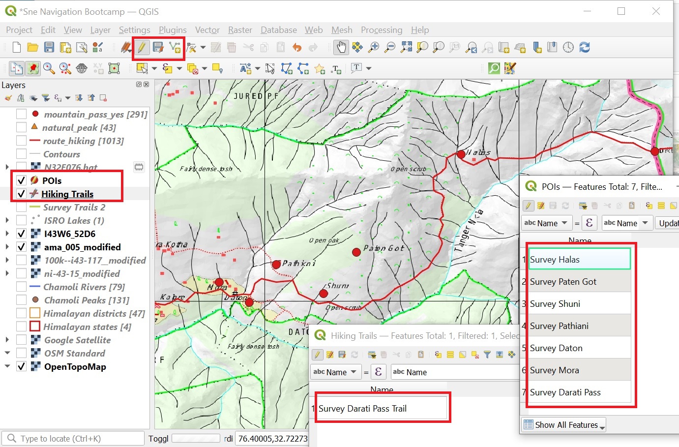
In this module we will digitize the Darati pass trail and surrounding settlements on the 4 geo-referenced maps (Survey, Olizane,…

Continue Reading →

Posted in: 8 Maps of the Himalayas, Alpine Bootcamp DIY

Alpine Hiking 8C – AMS Maps

December 29, 2021 Peter Van Geit

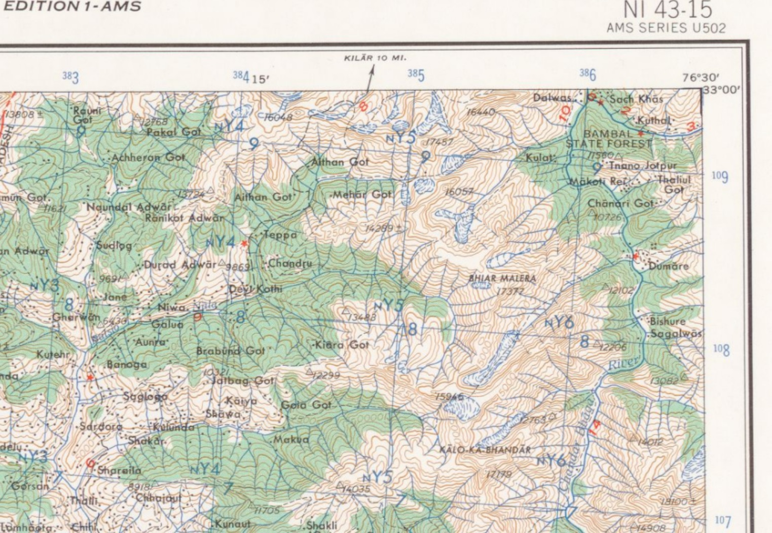
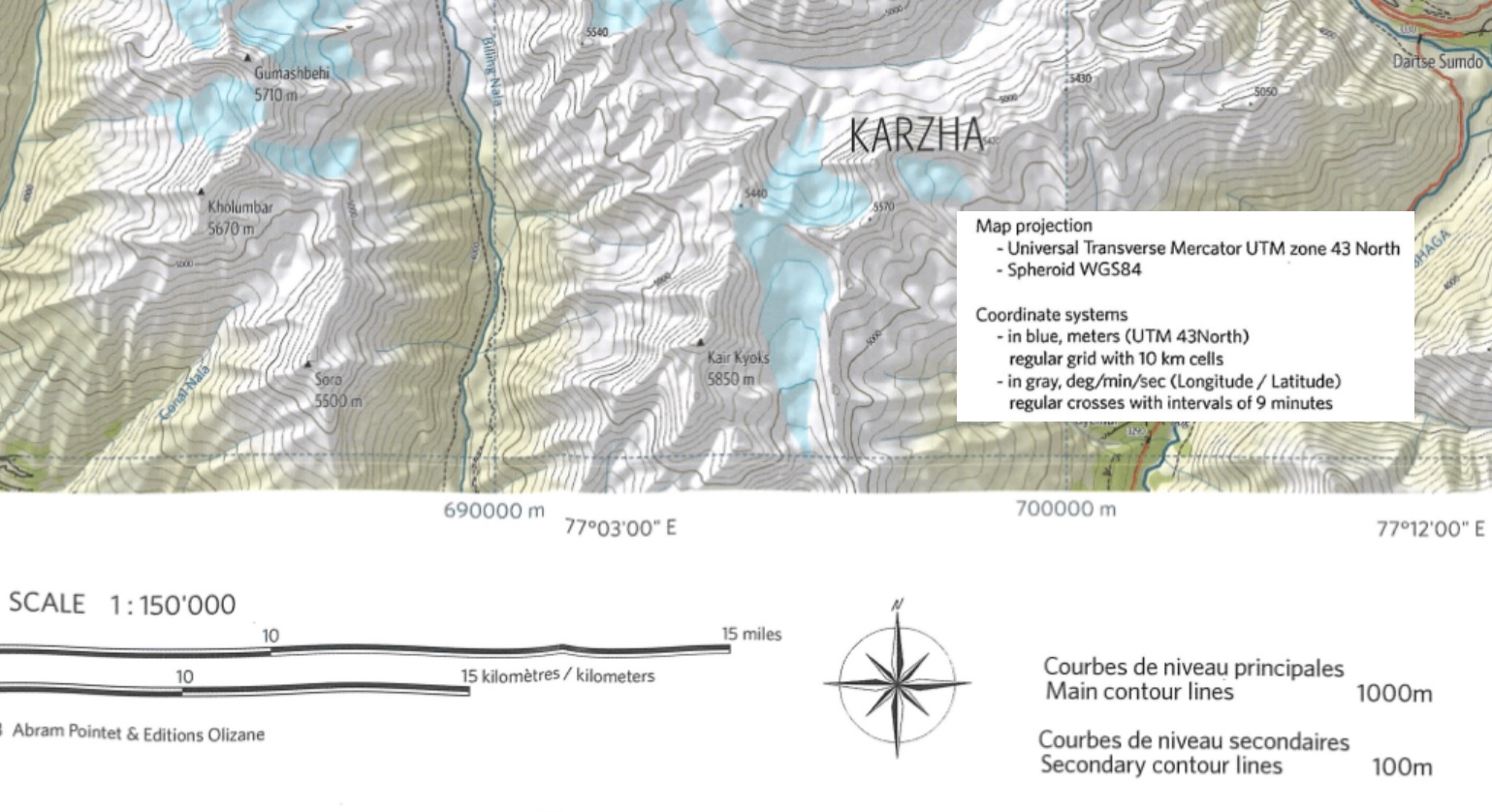
The US Army Map Service (AMS) was the military cartographic agency of the United States Department of Defense from 1941…

Continue Reading →

Posted in: 8 Maps of the Himalayas, Alpine Bootcamp DIY, Himalayan Maps Filed under: Himalayan Maps

Alpine Hiking 8B – Soviet Maps

Peter Van Geit

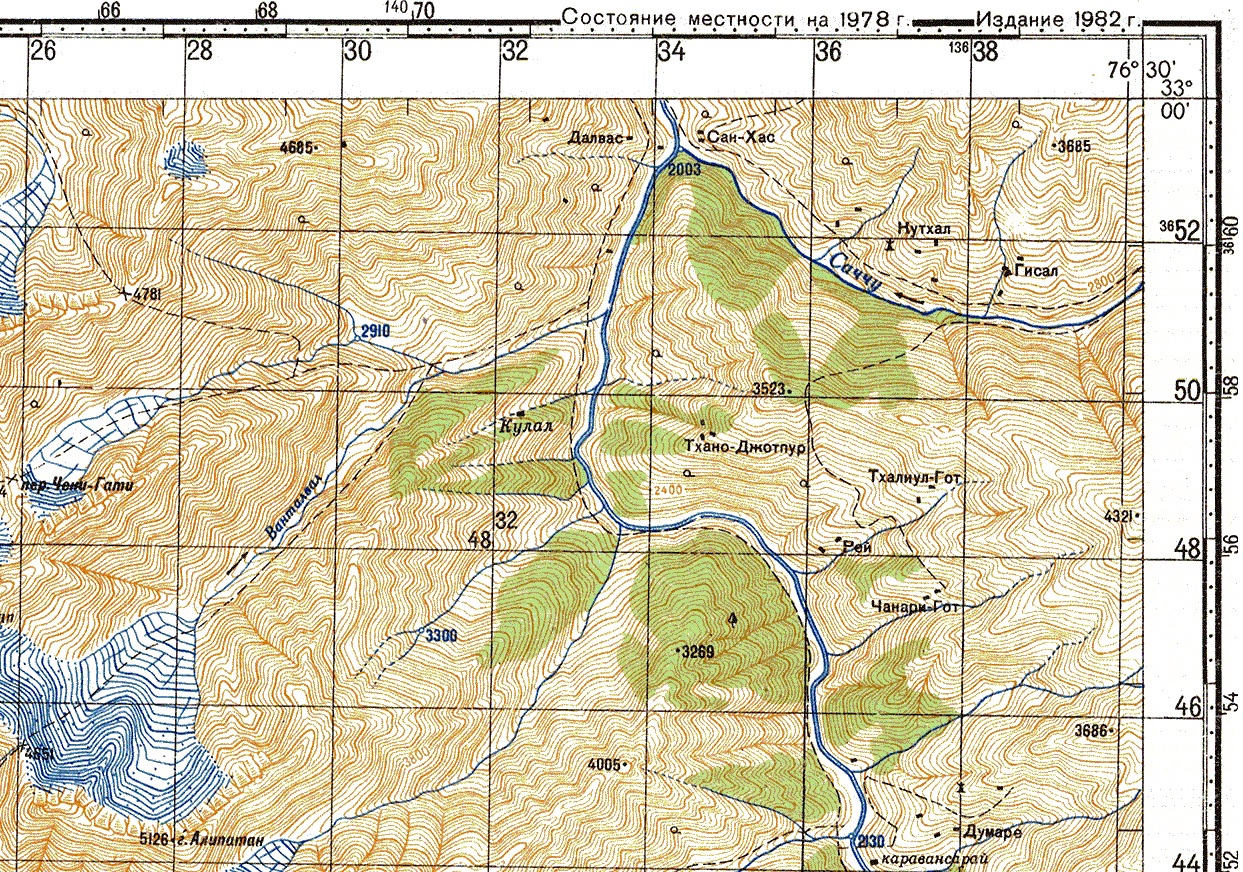
During the cold war the Soviet military secretly mapped the entire world using detailed topographic maps: Although focus was on…

Continue Reading →

Posted in: 8 Maps of the Himalayas, Alpine Bootcamp DIY

Alpine Hiking 8A – Olizane Maps

December 28, 2021 Peter Van Geit

Welcome to “Chapter 8 – Map Sources” of the Alpine Hiking Bootcamp. In this chapter we’ll compare topographic maps of…

Continue Reading →

Posted in: 8 Maps of the Himalayas, Alpine Bootcamp DIY, Himalayan Maps Filed under: Himalayan Maps

Alpine Hiking 7E – Hiking Routes

December 27, 2021 Peter Van Geit

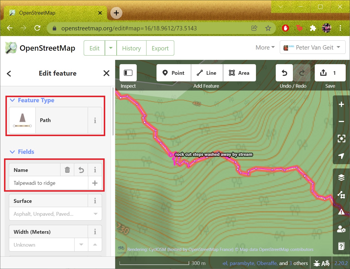
Congratulations in mapping your first trail in OSM! The trail is now shown in any OSM web client or mobile…

Continue Reading →

Posted in: 7 Open Street Maps, Alpine Bootcamp DIY, Open Street Maps Filed under: Open Street Maps

Alpine Hiking 7D – Trails

December 26, 2021 Peter Van Geit

In the previous module we mapped human settlements based on an external geo-referenced data set. In this module we will…

Continue Reading →

Posted in: 7 Open Street Maps, Alpine Bootcamp DIY, Open Street Maps Filed under: Open Street Maps

Alpine Hiking 7C – Settlements

December 25, 2021 Peter Van Geit

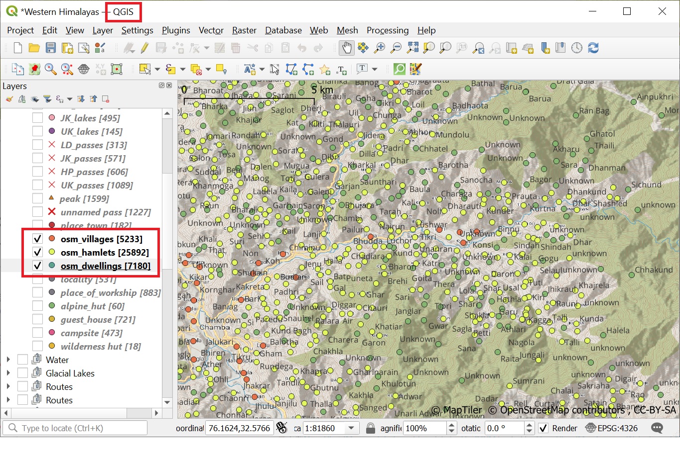
As mentioned in earlier chapters, human settlements are important base points for the alpine style hiker (food supply, night shelter,…

Continue Reading →

Posted in: 7 Open Street Maps, Alpine Bootcamp DIY, Open Street Maps Filed under: Open Street Maps

Alpine Hiking 7B – OSMAnd

December 24, 2021 Peter Van Geit

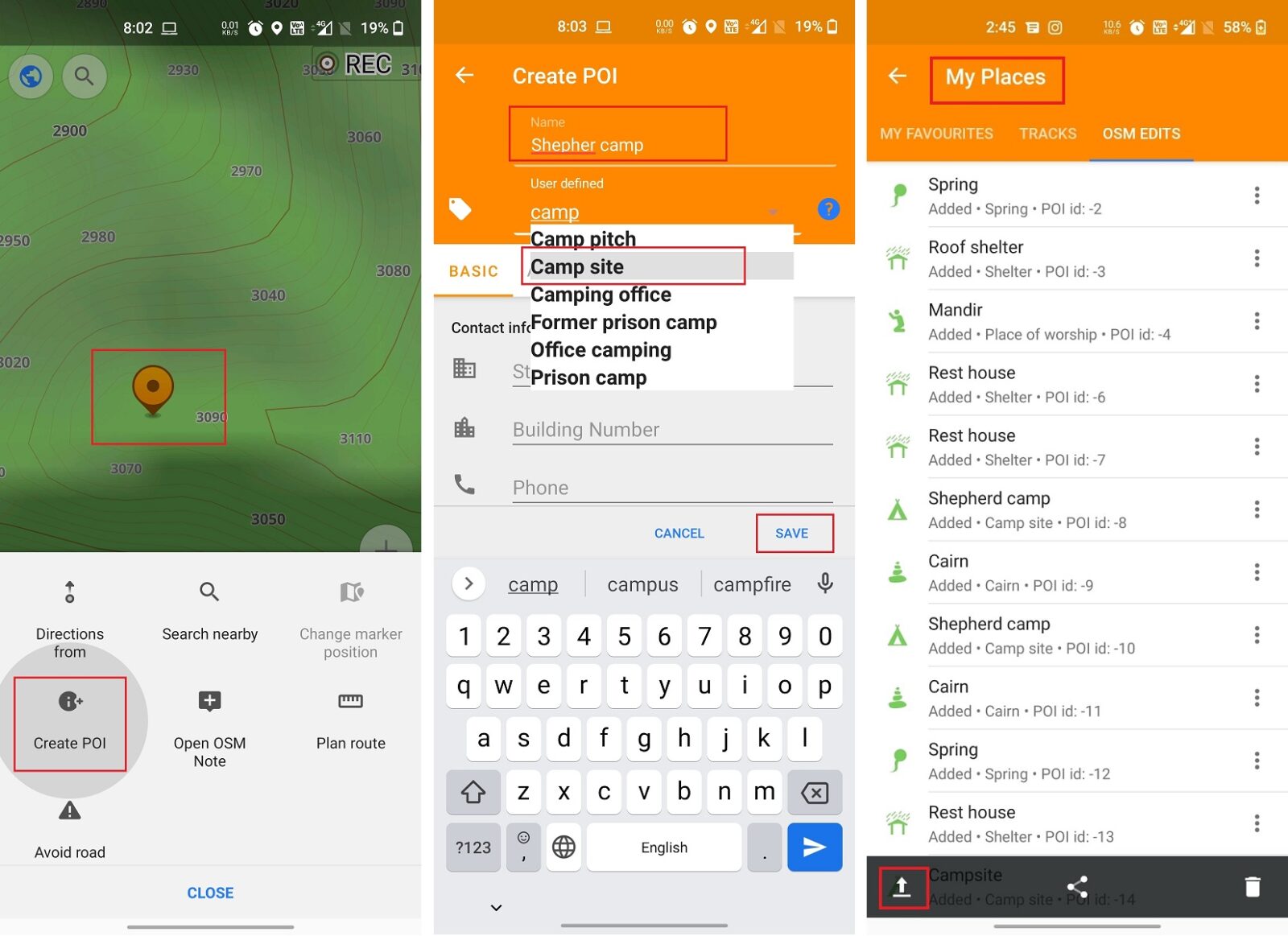
In module 2 we explore the various ways to contribute to Open Street Maps through the mobile app OSMAnd: Adding…

Continue Reading →

Posted in: 7 Open Street Maps, Alpine Bootcamp DIY, Open Street Maps, Ultra Journeys Filed under: Open Street Maps

Alpine Hiking 7A – Getting Started

December 23, 2021 Peter Van Geit

Congratulations on completing the first 6 chapters of the Alpine Hiking Bootcamp. You now mastered the basic concepts including planning…

Continue Reading →

Posted in: 7 Open Street Maps, Alpine Bootcamp DIY, Open Street Maps Filed under: Open Street Maps

Post navigation

Page 22 of 96
← Previous 1 … 21 22 23 … 96 Next →

Need guidance on hiking in the Indian Himalayas? Contact me:

  • WhatsApp
  • Instagram
  • Mail
  • YouTube
  • Patreon
  • Facebook

Search

Recent Posts

  • Trans Himalaya 2026 (East-West)
  • Planning a Himalayan traverse
  • Trans Himalaya 2026
  • Alpine Field Bootcamp 2026
  • Freediving Course

Contents

  • About (167)
    • Articles (40)
      • Blogs (12)
      • ExplorersWeb (7)
      • IMF (4)
      • Outdoor Journal (7)
      • The Himalayan Club (10)
    • Awards (9)
    • Interviews (19)
    • News (14)
    • Profile (5)
    • Relief (16)
    • Talks (70)
      • Colleges (12)
      • Corporate (21)
      • Public (22)
      • TEDX (11)
  • Himalayas (136)
    • Cycle Touring (9)
    • Gears (11)
    • Geography (3)
    • Guiding Hikers (19)
    • Hiking Routes (20)
    • Himalayan Regions (22)
    • Lakes (12)
    • Nepal (10)
    • Q&A (4)
    • Running (10)
    • Videos (15)
  • Maps (128)
    • Himalayan Maps (18)
    • Himalayan Traverses (15)
    • Journey Maps (26)
    • Mapping Himalayas (15)
    • Navigation (12)
    • Open Street Maps (12)
    • Survey of India (7)
    • Topography (12)
    • Traverse Planning (22)
  • Online Courses (129)
    • Alpine Bootcamp DIY (64)
      • 1 Maps & Route Planning (5)
      • 2 Navigation (6)
      • 3 Journey Planning (8)
      • 4 Minimalist Gears (7)
      • 5 Himalayan Terrains (8)
      • 6 GIS (7)
      • 7 Open Street Maps (5)
      • 8 Maps of the Himalayas (5)
      • 9 Atlas of the Himalayas (4)
      • 9B Geometrics of Himalayas (6)
    • Alpine Field Bootcamp (17)
    • Alpine Webinar (11)
    • Environment (4)
    • GIS (12)
    • Navigation Bootcamp (13)
    • Social Media (4)
  • Sahyadris (39)
    • Regions (25)
    • Traverses (14)
  • Ultra Journeys (556)
    • EuroVelo8 2025 (1)
    • Himachal Autumn 2021 (27)
      • Maps (2)
      • Traverses (24)
      • Videos (1)
    • Himachal Spring 2021 (25)
      • Traverses (24)
      • Videos (1)
    • Himalaya 2018 (65)
      • Articles (10)
      • Maps (3)
      • Talks (5)
      • Traverses (43)
        • Chamba, Pangi (13)
        • Kinnaur, Spiti (9)
        • Kullu, Kangra (16)
        • Ladakah, Zanskar (5)
      • Videos (4)
    • Himalaya 2019 (112)
      • Articles (14)
      • Maps (4)
      • Talks (6)
      • Traverses (78)
        • Chamba, Pir Panjal (11)
        • Dhauladar (14)
        • Kullu (11)
        • Ladakh (16)
        • Uttarakhand (16)
        • Zanskar (10)
      • Videos (3)
    • Himalaya 2022 (5)
      • Maps (4)
    • JK Spring 22 (23)
      • Articles (2)
      • Maps (2)
      • Traverses (18)
      • Videos (1)
    • JK Winter 22 (11)
      • Maps (1)
      • Traverses (9)
      • Videos (1)
    • Pangi 2015 (6)
      • Articles (3)
      • Traverses (3)
    • Pangi-Zanskar 2016 (4)
      • Articles (2)
      • Traverses (2)
    • Sahyadri 2018 (27)
      • Articles (1)
      • Traverses (26)
    • Sahyadri 2019 (77)
      • Articles (5)
      • Map (1)
      • Media (15)
      • Talks (12)
      • Traverses (16)
      • Videos (2)
      • Webinars (26)
    • Sahyadri 2022 (1)
      • Map (1)
    • Shimla-Leh 2013 (6)
      • Articles (3)
      • Traverses (3)
    • Spiti 2015 (6)
      • Articles (3)
      • Traverses (3)
    • Spiti-Pangi 2017 (8)
      • Articles (4)
      • Traverses (4)
    • Srilanka 2015 (4)
      • Articles (3)
      • Traverses (1)
    • Ultras 2017 (7)
      • Articles (2)
      • Races (5)
    • Uttarakhand 2020 (93)
      • Articles (7)
      • Maps (2)
      • Traverses (82)
        • Bageshwar (5)
        • Chamoli (31)
        • Dehradun (1)
        • Pauri Garhwal (5)
        • Pithoragarh (9)
        • Rudraprayag (8)
        • Tehri Garhwal (22)
        • Uttarkashi (12)
      • Videos (1)
    • Vietnam 2016 (6)
      • Articles (3)
      • Traverses (3)
    • Vietnam 2018 (32)
      • Articles (7)
      • Traverses (25)

Site Index

ABC (19) Articles (32) Chamba (25) Chamoli (35) Corporate (21) Dhauladhar (20) Featured (27) Floods (24) GHNP (18) GIS (31) Guidance (19) Hiking Routes (21) Himalayan Maps (18) Himalayan Regions (22) Himalayan Traverses (15) Interviews (27) Jammu (34) Journeys (18) Kangra (28) Kullu (36) Ladakh (27) Lahaul (26) Lakes (19) Mapping Himalayas (15) Maps (27) Navigation (13) News (26) Open Street Maps (18) Pangi (14) Pir Panjal (13) Pithoragarh (15) Presentations (31) Public (15) Running (16) Sahyadri (35) Sahyadri Regions (27) Sahyadri Traverses (26) Tehri Garhwal (31) th19 (14) Traverse Planning (25) Uttarakhand (14) Uttarkashi (20) Videos (15) Vietnam (34) Zanskar (23)
  • Home
  • Blog
  • About
  • Online Courses
  • Himalayas
  • Maps
  • Journeys
  • Sitemap
  • Home
  • Blog
  • About
  • Online Courses
  • Himalayas
  • Maps
  • Journeys
  • Sitemap
Copyright © 2019 UltraJourneys - Supported by dreams