In this chapter we will familiarize ourselves with mobile navigation and route planning through OSMAnd using Open Street Maps (OSM) as a base map. OSM maps are geo-referenced – each feature (village, peak, trail…) shown on the map is geo-coded which means it’s exact location on the ground (planet) is known. Therefore our current location on the ground (determined by the phone GPS) can be displayed directly on the map (blue arrow) to see our relative position with respect to other features shown on the map.
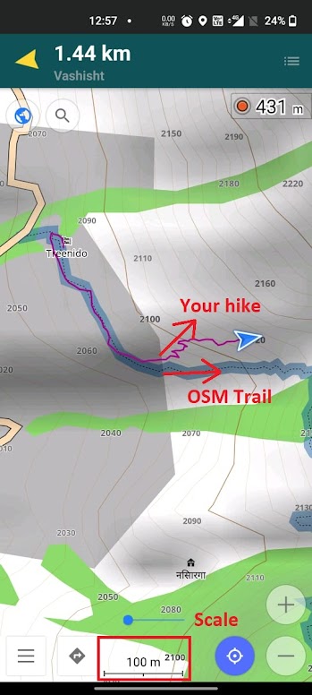
You can zoom in / out on the map – the scale of the current view is shown at the bottom indicating the actual distance on the group. You can zoom out (scale 2km, 5km) to get an overall view of the entire route / surrounding region. While navigating it’s recommended to keep the scale at max. 100-200m so you can track your progress / movement on the map and quickly identify in case you are wandering off from the planned route.
As we hike along a trail through the mountains our position (blue arrow) will move along the trail shown on the map. If the arrow moves away from the trail it means we are going wrong (as shown in below image) and have to get back onto the trail. The arrow shows our direction of movement allowing us to easily identify whether we are moving in the right direction towards our target destination.
Route Planning
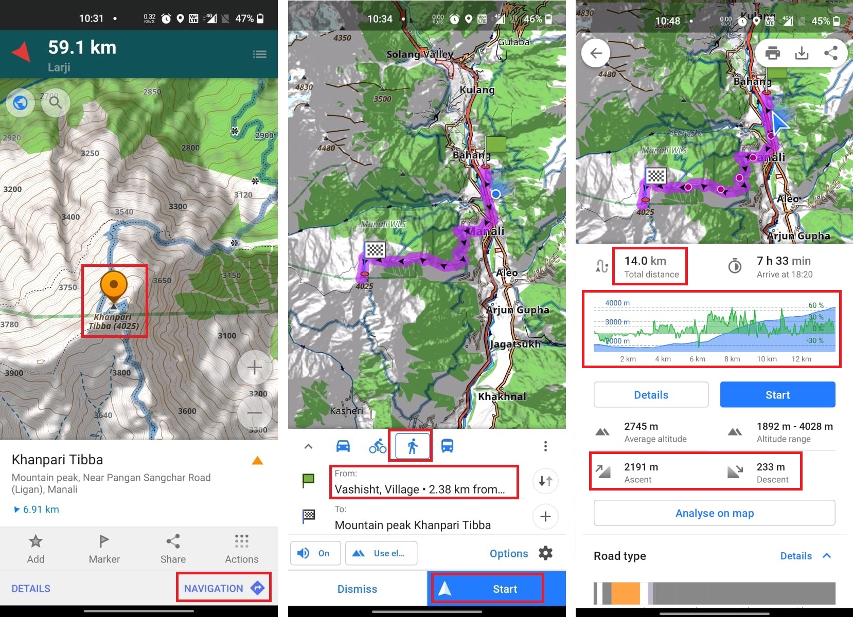
Let’s now play around with some of the route planning features of OSMAnd. Search for “Khanpari Tibba”, a peak West of Manali and press Navigation to automatically plan a route to the peak. In the routing screen choose “Hiker” to enable trail routing (default is “Car”, road-based routing). In “From” option chose the starting location as “Vashist”. OSMAnd will now identify an optimal trail from Vashist to Khanpari Tibba.
Click “Details” to show additional useful info on the route: total distance, ascent (elevation gain), descent (drop) and an elevation profile (elevation – blue, slope /steepness – green). The elevation profile gives a clear understanding of effort / climb and is essential in planning (duration of) your hike.
Route Features
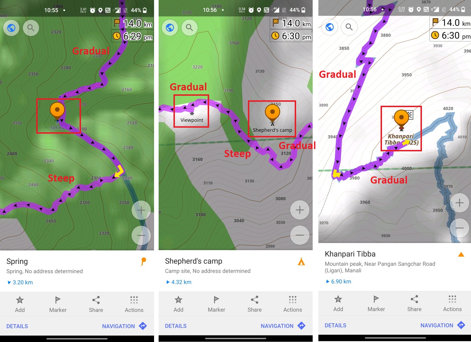
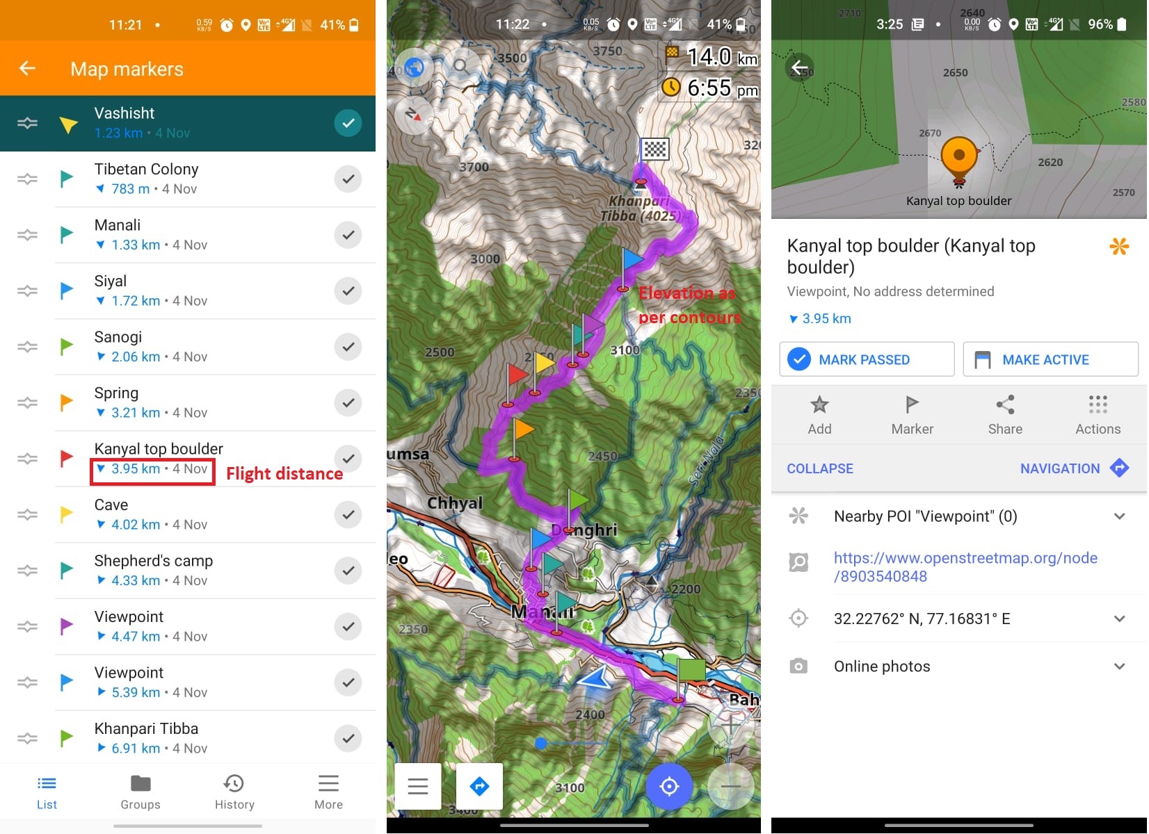
Zoom into the route to get a better understanding of your planned hike. Contours show steep (close contours) vs. gradual sections (spaced contours) of the route. Important outdoor features for hikers like campsites, springs, shelters, viewpoints, peaks, lakes are show along the route. You can click on any feature along the route to show the (flight) distance from your current position. Importantly the hiker now knows the distance and climb to each feature: Spring (2200m, drinking water), campsite (3150m, night halt), viewpoint (3230m), Khanpari Tibba peak (4020m).
Marking Features
You can put markers (flags) to highlight key outdoor features on the map for easy tracking in OSMAnd. This allows you to keep track of what’s ahead and plan your rest points, shelters, food points, night stay. Knowing the flight distance and elevation gain (altitude difference) to the next point allows you to estimate the duration to reach that point:
Adding Features
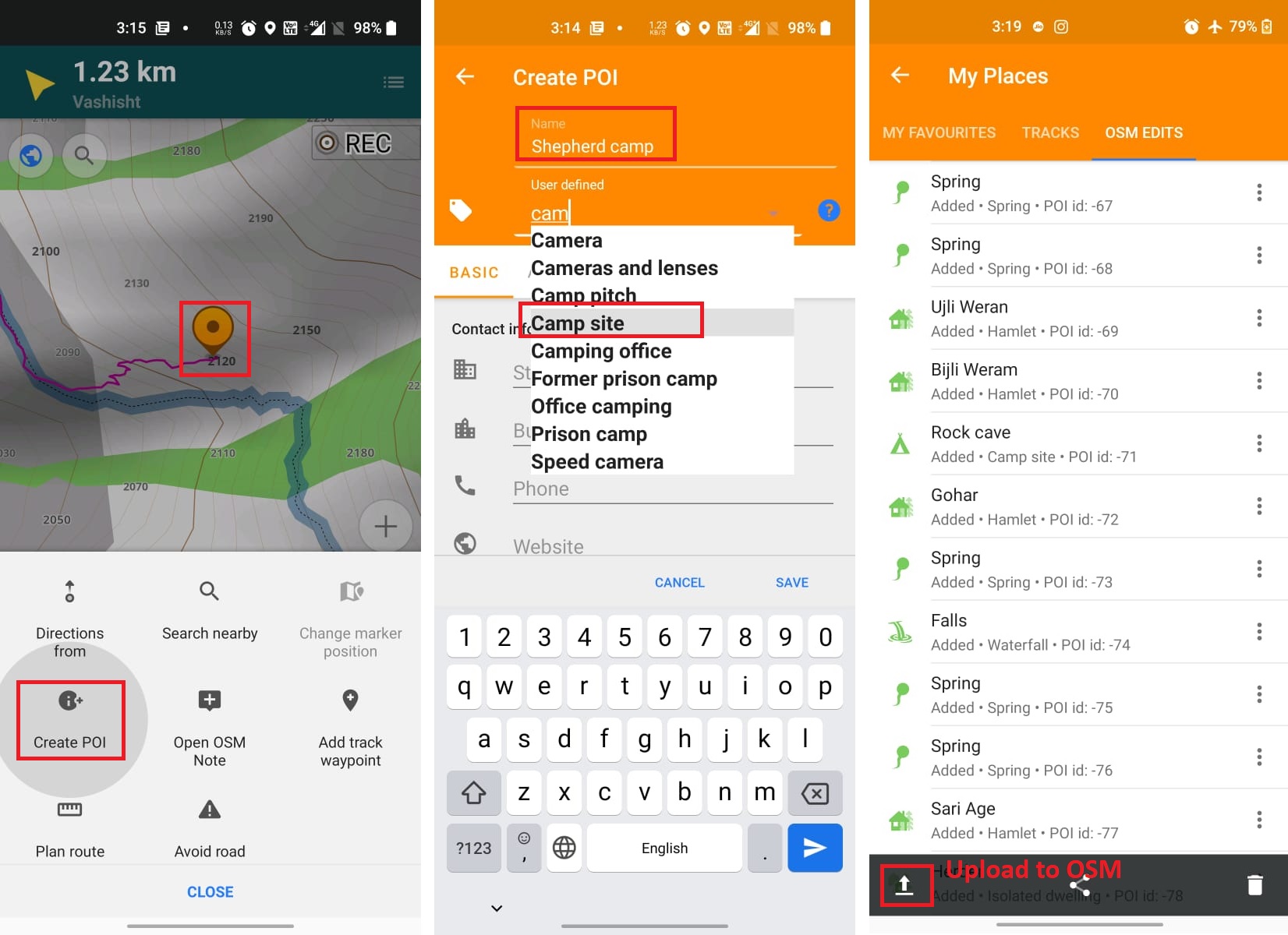
As you hike in the mountains and come across important outdoor features you can add the same to Open Street Maps so other hikers can benefit when visiting the same route. Enable the “OpenStreetMap Editing” plugin in OSMAnd and create an OSM account (required for editing).
Any useful feature – campsite, spring, viewpoint, shelter, (still unmapped) hamlet, falls, peak, etc. can be marked. Select your current location on the map, choose Actions – Add POI. Provide a descriptive name and correct OSM type. Features can be marked while offline (no Internet) and will be listed in the “My Places” dialog. Once you reach back to network you can upload all marked Features to OSM. The newly added POIs will appear (after a while) in the various OSM viewers used by hikers world-wide.
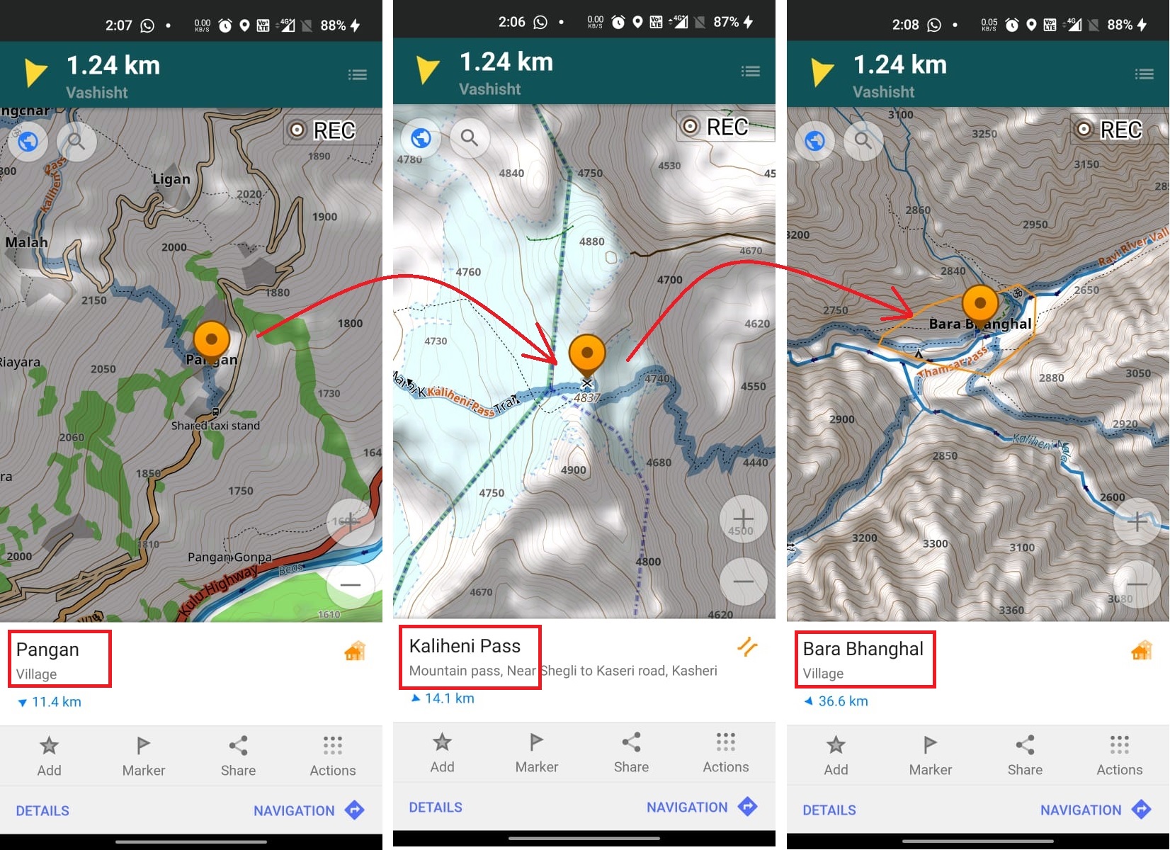
Assignment
Search the “Kaliheni pass” in OSMAnd and mark / flag all key features (important to hikers) along the route starting from Pangan village in the Kullu valley to Bara Bhanghal in Kangra. These features are essential to plan your hike: night halts, food points, drinking water, shelters, trail splits, etc. Distance / elevation gain to each point is essential information to plan your journey. Upload screenshots in a public folder showing all your flags (sequential from start to end point) in both list and on the map for review.
With more than 400 hiking routes, OSM has one of the largest hiking networks across the Western Himalayas.